
Chapter 6 Hazards And Disasters
A news bulletin was frequently telecasted for the last two days to aware people of the forecast of natural hazards and disaster-a super cyclone with a speed of 275 km/hour may strike the coast of Sundarban.
Read And Learn Also WBBSE Notes For Class 9 Geography and Environment
As a result, local people are tensed and worried about the news and the Disaster Management team of West Bengal is also ready to rescue people at any moment, if required.
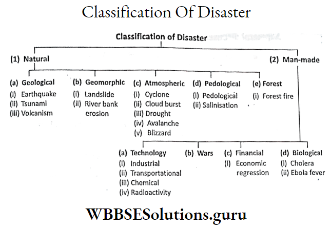
Types Of Hazards And Disasters
Concept Of Hazards And Disasters:
You are very much familiar with the terms ‘Hazards’ and ‘Disasters’ which are synonymous with the common people. Actually, these two words are different at least in their impact on life and the environment.
Class 9 Geography Chapter 6 WBBSE Solutions
Hazard
The word ‘hazard’ probably has been coined from the ancient Anglo-French word ‘hazard’. The other opinion is that the word ‘hazard’ is coined from the Arabian word ‘Ar-zahr’ (which means death).
Hazards are of three types
- Natural hazard Example. earthquake, volcanism, tsunami, cyclone etc.
- Man-made hazard Example. hazards due to atomic bomb explosions, land, water, air pollution, wars etc.
- Quasi-natural hazard. Example. Flood, drought, landslide due to deforestation etc.

Disaster
The word Disaster is coined from the French word ‘Desastre’ which literally means ‘bad star’. A hazard may be turned into a disaster when there is loss of life and properties as well as environmental degradation.
Actually, a phenomenon is said to be hazardous when it happens rarely it happens, there is a risk of loss of life and properties, and its threats the sustainability of the environment.
Incidents are said to be disasters when
- human life and activities are disturbed there is a loss of life and properties on large scale,
- transport and communication systems are disrupted.
Hazards are, therefore, natural or man-made incidents that may lead to disasters which are responsible for the loss of life and properties. So, all disasters are hazards but all hazards are not disasters.
Difference Between Hazards And Disasters:

Class 9 Geography Chapter 6 WBBSE Solutions
Chapter 6 Hazards And Disasters A General Discussion Of Different Types Of Hazards And Disasters
Flood:
The overflow of a river may cause flood in its adjoining areas. Floods may cause loss of life as well as epidemics and even threats to cultivation.
In 1935, due to the flood of the river Yangtze Kiang, there was the loss of millions of people in China.
In 1978, there was a huge loss of life and property in the southern part of West Bengal due to the flood of the river Damodar.

Flood Prone Areas In India
According to the report of the Central Water Commission about 11% area of our country is flood-prone which includes the river valleys of West Bengal, namely Ajoy, Damodar, Kangsabati, Silal, Tista, Torsa, Bhagirathi, Mahananda etc.
the river valleys of Gomati, Ghaghara, Kosi, Yamuna, and Chambal in Uttar Pradesh; Tejpur, Dibrugarh, Guwahati areas of Brahmaputra valley in Assam; river basin of Mahanadi, Godavari, and Krishna.
Kavery of Peninsular India, and the lower basins of the river Narmada and Tapi in Western India.

Causes Of Flood
The causes of floods are mainly
- Wet spell for a long time,
- Heavy rain even over a short period,
- Tsunamis in coastal areas,
- Landslides across the river,
- Discharge of excessive water from the reservoir etc.
Drought
Drought is an example of a climatic disaster. Areas of a long dry spell are known as droughts. The opinion of the Indian Meteorological Department, 75% less rain than expected rainfall in an area is said to be drought.
Effects Of Drought :
Drought is responsible for hazards in economic activities like agriculture, animal rearing etc. as well as a scarcity of drinking water.
Indian Meteorological Department has classified droughts into two categories based on rainfall amount
- In severe drought, rainfall is 50% less than expected and
- In Moderate drought, rainfall is 25% to 50% less than the expectation.
Class 9 Geography Chapter 6 Important Questions
Drought Prone Areas In India
Drought-prone areas of India are Jaisalmer, Churu and Ganganagar in West Rajasthan; Kachchh and Saurashtra in Gujarat; rainshadow areas of Western Ghats which includes Eastern and Southern Maharastra.
the northern part of Karnataka and western part of Telangana, the western part of Uttar Pradesh; Tirunevelli and Coimbatore of Tamilnadu; Kalahandi of Odisha; Puruliya, Bankura districts of West Bengal etc.

Causes Of Drought:
Droughts are caused by
- less rainfall than expected,
- loss of humidity of soil due to a high rate of evaporation.
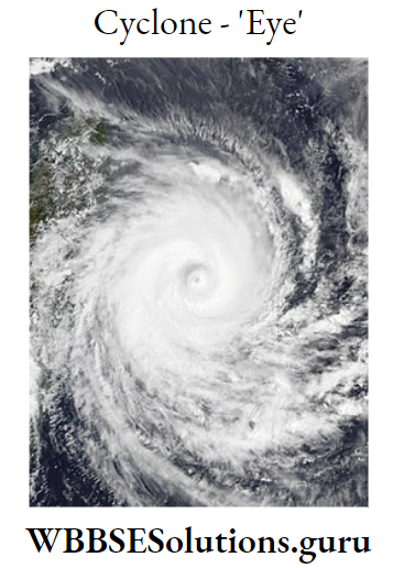
Cyclone
Cyclone is a meteorological or natural disaster. A sudden drop in air pressure develops an intense low-pressure cell to which the wind blows spirally upward with high velocity.
This is known as Cyclone. Its high speed, continuous heavy rainfall and huge sea waves may cause severe threats to common people.
Effects Of Cyclone:
Cyclones and Super cyclones are one of the most destructive disasters which are responsible for the loss of life and wealth.
In 1991, millions of people died in Bangladesh due to a strike by cyclone. In 1999, a super cyclone that hits the Odisha coasts was responsible for the huge loss of life including cattle.
In 2008, also millions of people died in another severe cyclone.
Causes Of Cyclone:
Tropical cyclones are originated over the seas where the temperature is 27°C a long 15° latitudes and become powerful slowly and move towards nearby landmasses.
Class 9 Geography Chapter 6 Important Questions
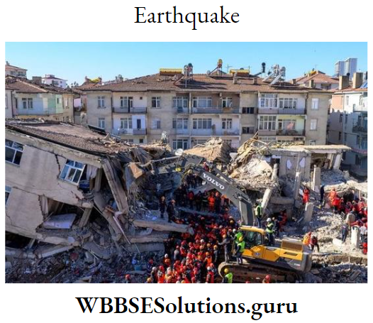
Chapter 6 Hazards And Disasters Earthquake
An earthquake is a physical disaster. Depending on the intensity which is measured by the Richter scale, the earthquake may be severe and destructive when the intensity is above 7.
Earthquake-Prone Areas In India:
Earthquake is frequent along the plate boundaries, fold mountain region and along the Pacific Ring of Fire where volcanoes are common.
In India, therefore, the Himalayan mountainous region in Northern India, Northeast India and Gujarat are very much prone to earthquakes.
In 1976, in China, about 7 lakh people died due to the earthquake. In 2001, an earthquake at Kachchh in Gujarat was responsible for the death of about 10 thousand people.
Causes Of Earthquake:
Earthquakes are mainly caused by physical factors like plate movements, volcanism, and upliftment of the fold mountain.
Man-made causes like the construction of a reservoir on weak rock strata, and the explosion of an atomic bomb is also responsible for earthquakes.
Tsunami
Huge sea or ocean waves are called ‘Tsunami’ by the Japanese. Tsunamis are physical disasters that are closely connected to volcanoes.
In the Japanese language ‘Tsu’ means port and Nami’ means wave. So, Tsunamis are huge waves that are actually originated at sea or ocean bottom due to seaquakes and strike the coastal port or town.
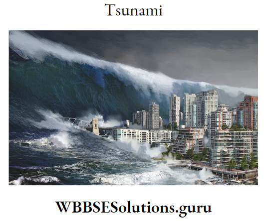
Effect Of Tsunami:
Numerable lives including animals died and were washed away in the coastal region, ships and boats are destroyed, and transportation and communication lines are destroyed near the sea coasts.
On 26th December 2004, a seaquake at the Indian Ocean bottom with an intensity of 8-9 Richter caused the death of more than 3 lakh people in the adjoining 11 countries.
Class 9 Geography Notes Bengali Medium Chapter 6
Causes Of Tsunami :
Seaquakes developed at the sea or ocean bottom with an intensity above 8 Richter produces huge waves or tsunamis. Huge ice chunks that fall on the sea or ocean from the nearby landmasses may also produce tsunamis.
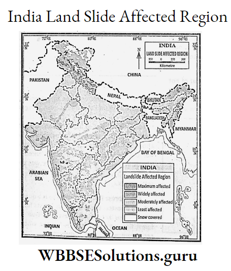
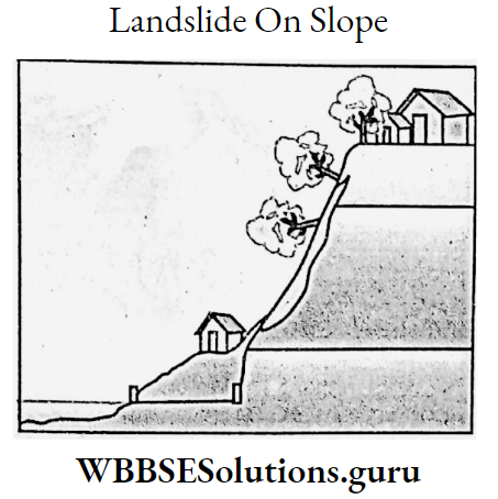
Landslide
A landslide is a quasi-natural disaster. Along the slopes and foothills of a mountain, portions of landmasses when slide down the phenomenon is known as Landslide.

Effects Of Landslides:
In the Himalayan mountainous region, especially in North Bengal, landslides are frequent in the rainy season. Lives and properties are covered under landslides. Roadways and communication systems are also disconnected.
Causes Of Landslide:
Landslides are caused by physical factors like the instability of hillslopes, due to earthquakes, and rainwater percolating into the rocks may loosen the texture of the rock.
Landslides are also caused by man like deforestation in the mountains, unscientific cultivation on the mountains, and construction works like houses, bridges, canals, roadways etc.
Chapter 6 Hazards And Disasters Avalanche
In cool climatic regions, on the mountain, an avalanche is a major physical disaster. When a large portion of the glacier slides down the slope of a mountain with great velocity, the phenomenon is known as Avalanche.
In 1970 about 20,000 people died in Peru of South America due to an avalanche. In 1979 about 280 people died in Lahul Valley in Western Himalayas due to an avalanche.

Causes Of Avalanche :
Avalanche is caused by earthquakes, heavy snowfall as well as melting of ice due to global warming.
Class 9 Geography Notes Bengali Medium Chapter 6
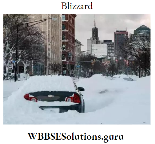
Blizzard
In cool climatic regions, blizzards are frequently occurring phenomena. These are, actually, natural disasters. Blizzards are generally, associated with temperate cyclones.
Blizzards are common in northern parts of Europe, northern parts of the USA, and Canada, especially, in winter. Lives, lines of communication, and settlements are totally disrupted and destroyed.
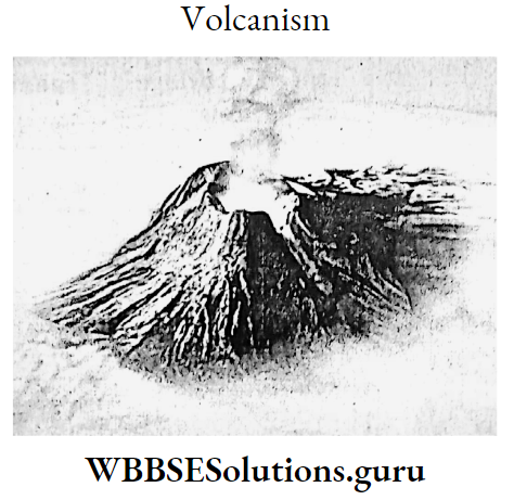
Volcanism
Gushing out of hot molten magma from the earth’s interior through cracks of the earth’s crust or a volcano is known as a volcanic eruption or volcanism.
The process may be sudden or even very slow. Due to volcanic settlements even villages and towns are covered by lava flow leading to total destruction of a civilisation.
In 1883 eruption of the Krakatoa volcano snatched away about 92 thousand lives. But Barren and Narcondam volcanoes of Andaman Nicobar Islands in India when erupted, there was no such death as the region was devoid of settlements.
Forest Fire
Forest fire is a quasi-natural disaster. The burning of vast forests for a long time is known as Forest fire. Due to forest fire not only the trees but the whole ecosystem of the area is disrupted.
Affected Areas:
Forest fire is common in the forests of Jharkhand, Madhya Pradesh, and Chhattisgarh in India as well as in the forests of Australia, the USA, Russia etc.
Class 9 Geography Chapter 6 Summary
Chapter 6 Hazards And Disasters General Nature Of Hazards And Disasters In West Bengal Their Impact
West Bengal stretches from the Himalayas in the north to the Bay of Bengal in the south.
Due to this unique geographical location hazards and disasters like floods, cyclones, forest fires, earthquakes and tsunamis, landslides etc. are common in West Bengal.

Incidents Of Hazards And Disasters In West Bengal

Source:
- Disaster Management Department, Govt. of West Bengal.
- Seismic Centre, Pune, Maharashtra.
- Hazards, disasters and your community: A primer for Parliamentarian version 1.0. National Management Division, Govt. of West Bengal.
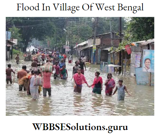
Flood In West Bengal
Flood is the major cause of hazards and disasters in West Bengal. West Bengal is a land of rivers. In rainy seasons most of the rivers overflow particularly when there is a long wet spell or a heavy shower.
As a result, the rivers flood their adjoining areas. In the northern part of West Bengal the rivers namely, Tista, Torsa, Jaldhaka etc.
In the central part, the river is like Ganga and in the southern part, the rivers like Damodar, Ajay, Rupnarayan, Kangsabati etc. are responsible for frequent floods in the rainy season.
The dams under D.V.C. and Mayurakshi projects in Jharkhand like Maithan, Panchet, and Massanjore release a huge amount of water which floods vast areas of Bardhaman, Bankura, Birbhum, Haora, Hugli, Purba Medinipur districts of West Bengal in the rainy season.
The river Ganga and its distributaries flowing through Nadia and North 24 Parganas have silted so much that this area also becomes flooded in the rainy season.
Construction of the Farakka barrage across the river Ganga is responsible for floods in the Murshidabad district.
Class 9 Geography Chapter 6 Summary
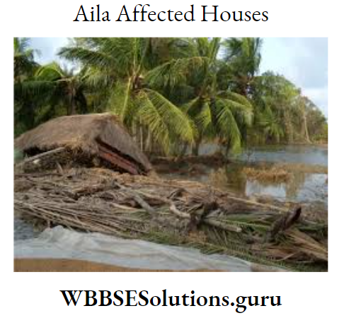
Cyclone In West Bengal
From April-May to October-November months strong tropical cyclones develop in the North Indian Ocean and the Bay of Bengal.
These cyclones frequently hit Digha and Sundarban coasts where lives and properties are destroyed in large quantities. Cyclones are actually the second most important cause of hazards and disasters in West Bengal.
Drought:
Rainfall is less than expected in the western districts of West Bengal, namely Puruliya, Bankura, Birbhum, Paschim Medinipur and the western part of Bardhaman of West Bengal.
The years in which there is long dry spell due to the erratic nature of monsoon wind the western districts of West Bengal experience drought conditions.
As a result, agriculture, pisciculture and animal rearing are hampered. So, droughts are actually, physical disasters in western districts of West Bengal.
Landslide In West Bengal
Landslides in the mountainous region of North Bengal, especially, on the hills of the Darjeeling district are common phenomena such as natural disasters. Lives and properties as well as communication systems become totally disrupted over a vast area for a few days.
Other disasters which are occasionally found in West Bengal include:
- Forest fires in the districts of Puruliya, Bankura, and Paschim Medinipur.
- Earthquakes may occur as natural disasters though West Bengal is made of alluvium soil the faults underlying may cause earthquakes.
- Tsunamis originated in the Indian Ocean and the Bay of Bengal and may cause disasters in Sundarban and along the Digha coasts.
Chapter 6 Hazards And Disasters Disaster Management
Concept Of Disaster Management-Role Of Students:
Disasters cause long-term interruptions to the function of a community or a society.
Disaster Management is to reduce the impact of a disaster and is meant for the sustainable development of society and to rehabilitate vulnerable people such as the disabled, elderly people and children.
The disaster management mechanism consists of three stages
- Pre-disaster,
- During disaster and
- Post-disaster
Pre-Disaster Management
Measures to be taken as preparation to encounter the disaster. These are
- Investigation, analysis and preparation of map for planning.
- Preparation of arrangements for the supply of food and drinking water as well as medical treatment.
- Interaction, planning and communication between the police force, fire station, army and disaster management department.
- Planning of work schedules for doctors, nurses, and health officers as well as arrangement of cars, vans, boats etc.
- Planning activities with trained personalities to form groups and to determine their duties and responsibilities.
- Frequent forecasting of the disaster at regular intervals through radio, television and other mass media.

Class 9 Geography Chapter 6 Summary
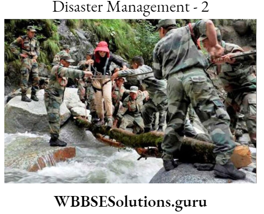
During Disaster
With the initiation of the disaster, a quick service of rescuing the victims and providing them food, drinking water, clothes and medicines as well as arranging security to mitigate other malfunctions are essential measures.
Post Disaster Management
Post-disaster management includes measures of renewal and rehabilitation. Renewal means repairing and reconstructing houses, institutions, and lines of communication including roadways, railways, electricity, drinking water etc.
Rehabilitation means the rearrangement of dwellings for the victims.
Role Of Students:
Students have great opportunities to play an important role in disaster management
measures.
- A student may keep records of weather forecasts so that he or she can aware of the common people with rain, and rainfall deficiency as well as the location and movement of a cyclone, floods and drought.
- A student can also be aware that people store polythene packets, torches, matches, candles, radios, batteries, dry foods etc. in time.
- A student can also aware people regarding measures to be taken during disasters like switch off electric lines, water taps, gas cylinders etc.
- As earthquake management measures, a student can aware of people by advising them to go outside in an open place or to take shelter under cots, tables etc., not to stand near the walls or glass furniture as well as not to ignite anyway.
- A student also tries to keep people calm and quiet during any kind of disaster as well as not to listen to any rumours.
- Finally, A student must be aware of land, water, air and forest pollution; otherwise, hazards and disasters will be very much fatal to society, community as well as environment leading to the disbalance of ecology in future.
Chapter 6 Hazards And Disasters Disaster Management Strategies In West Bengal
The Disaster Management measure taken in West Bengal are mainly two principal objectives oriented
- Preparedness of the people to combat the disaster and
- To mitigate the loss after the disaster is over, as far as possible.
Measures that already have been taken in West Bengal are
- Forecasting of hazards and disasters in advance as early as possible with the help of remote sensing satellites and GPS systems.
- Construction of multifunctional houses near big apartments.
- Rescue, renewal and rehabilitation activities are done by connecting all governmental departments under the control of the District Magistrate.
- Financial help to those people who belong to the B.P.L. category.
- Local people are engaged in all sorts of disaster management measures.
- Local people are inspired to combat the disaster with the help of local eco-friendly technologies.
- Mass awareness programmes regarding disaster management through radio, television, mass media, print media etc.
- Awareness programme for common people to store tarpaulin, plastic, ropes, boats, dry foods etc.