
Chapter 4 Geomorphic Processes And Landforms Of The Earth Introduction
Elementary Concept Of Geomorphic Processes
There is variation in size, shape and nature of the earth’s surface which is continuously formed by some internal or endogenetic and modified by some external or exogenetic forces, collectively known as Geomorphic processes.

Endogenetic forces are responsible for both slow and sudden changes in the earth’s surface by compression, tension, uplifting, subsidence, rifting, deformation etc. Excessive heat and intensive pressure of the earth’s interior are responsible for such forces.
Slow Or Diastrophism
Millions of millions of years take to change the earth’s surface slowly. The resultant landforms are Mountain, Plateaus, and Plain. Diastrophism includes pyrogenic and orogenic movements.
Read And Learn Also WBBSE Notes For Class 9 Geography and Environment
Plateaus and continents are uplifted on the earth’s surface slowly by continent-building or pyrogenic force which acts radially or vertically in the earth’s interior. Resultant landforms include Rift Valley, Block Mountain, and submerged and emerged coasts. Mountains are formed by horizontal or lateral forces which act tangentially in the earth’s interior. Compression on soft rocks develops Fold mountains.
WBBSE Class 9 Geography And Environment Notes
Sudden Movement
Sudden changes on the earth’s surface are responsible for earthquakes, and vulcanism. Resultant landforms are volcanic mountains, lava plateaus etc.
Exogenetic forces are active on the earth’s surface and are continuously modifying the primary landforms produced by endogenetic forces through the agents of gradation (aggradation and degradation) like rivers. Glacier, wind, sea waves as well as weathering, and mass wasting produce landforms known as Sequential landforms.
Chapter 4 Geomorphic Processes And Landforms Of The Earth Different Major Landforms Of The Earth
Landforms are the variation in size, shape, ruggedness, slope and nature of the earth’s surface, such as mountains, hills, plateaus, plains, lowlands, valleys etc.
Landforms are generally grouped into three categories
- Mountain,
- Plateau and
- Plain.
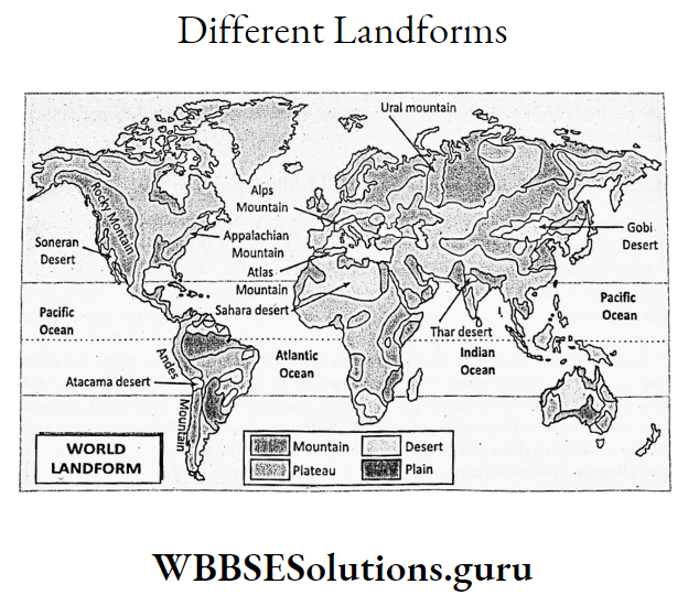
Lofty mountains occupy the central part of Asia. Southern and western parts of Europe and the western part of South America are also occupied by high mountain ranges.
Africa is a plateau continent. River valleys and coastal plains are almost common in each and every continent.
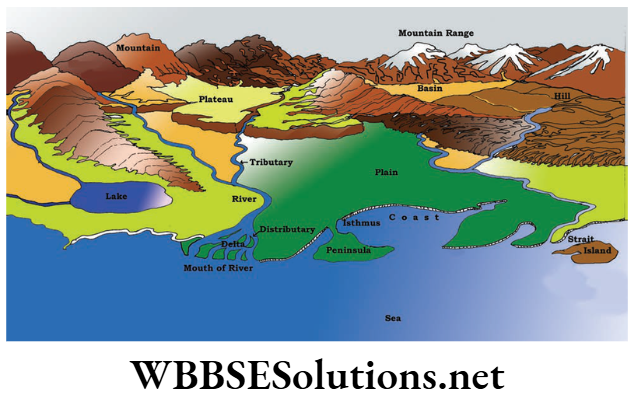
Mountains
Mountains Their Types:
An extensive area of the earth’s surface which rises over 1000 m above sea level with conical peaks, broad base, deep gorges and steep slopes is known as Mountain. Example. the Himalayas, Alps, Andes, Rockies etc.
Mountains are of four types based on their mode of formation-Fold mountains, Block (or Fault) mountains, Volcanic mountains and Residual mountains.
Fold mountains are formed due to the folding of soft sedimentary rock layers of the earth’s crust. Example. the Himalayas.
Displacement of raised blocks of rocks due to the fracture or fault produced on the earth’s crust by compressional or tensional forces on hard rocks form Block Mountain. Example. Satpura in India, Vosges in France.
WBBSE Class 9 Geography And Environment Notes
Aggradation of accumulated lava, ash and dust ejected from the magma chamber in the earth’s interior, eventually, develops volcanic mountains. Example. Mt Fuji in Japan, Barren in India.
Denudation or prolonged erosion of pre-existing mountains may, eventually, develop Residual or Relict mountains. Example. Appalachian of the USA and Aravallis in India.
Origins Of Fold Mountains (On The Basis Of Plate Tectonics)
There are several theories amongst which the most important is the Plate Tectonic theory regarding the origin of the Fold Mountains.
Plate Tectonic theory is the most modern theory which is an outcome of the investigation by the geologists T. Wilson, and D. P. Mackenzie.
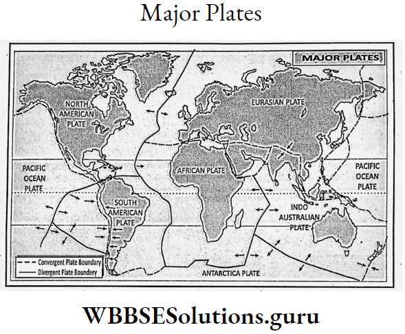
D. L. Pichou, the father of the theory explained it in 1968. According to this theory, continental crust consists of seven big plates, eight medium plates and twenty small plates.
Seven big plates are
- Eurasian plate,
- Pacific Ocean plate,
- North American plate,
- South American plate,
- Indo-Australian plate,
- African plate and
- Antarctica plate.
Plates are separated by fault lines and extend up to 70 km below the ocean and 150 km below the continents. Along the margins of the plates where two plates meet are found the plate boundaries.
Plates are floating on the upper part of the Mantle i.e. Asthenosphere due to convectional current produced by great temperatures in the earth’s interior.
WBBSEClass 9 Geography Notes
They move very slowly about 1 or 2 cm per year. As these plates are moving, there are three types of plate boundaries, when two plates move towards each other they form
- Converging plate boundaries when two plates move away from each other they form
- Diverging plate boundary. When two plates cross each other along plate margins they form
- Neutral plate boundary.
Fold mountains are formed along the converging plate boundaries.
Converging plate boundaries are of three types
- Continental-Continental plate boundary,
- Oceanic- Continental plate boundary and
- Oceanic-Oceanic plate boundary.
When Two Continental:
continental plates move each other shallow sea or geosyncline in between them is filled up by the sediments deposited from the marginal plates.
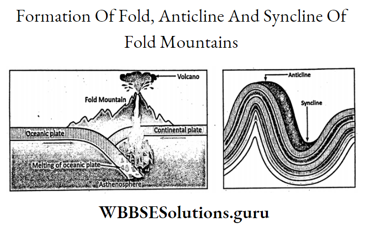
The plates collide and horizontal pressure squeezes up the soft sedimentary rock layers of the sea floor into a series of folds to form great Fold mountains of the world.
Two plates, namely the Angaraland to the north and the Gondwanaland to the south of the ancient Tethys geosyncline moved towards each other to squeeze up the sediments of the Tethys seafloor into the great folds of the Himalayas.

Continental:
oceanic plates also develop Fold mountains. Two such plates when converge, and the denser oceanic plate sinks below the lighter continental plate.
Eventually, one geosyncline develops in front of the continental plate. Ultimately sediments are deposited on this sea from which the folds are squeezed up to form the great Fold mountains.
Example. Rockies and Andes have formed by the sinking of the Pacific Oceanic plate below the North and South American plate.

Characteristics Of Fold Mountains:
Fold mountains are of various types. Folds are either uphold or downfold. Faults are common in Fold mountains.
Fold mountains are made of sedimentary rocks and fossils are, therefore, found in Fold mountains. Most of their peaks are conical.
Chapter 4 Geomorphic Processes And Landforms Of The Earth Concept Of Old And Young Fold Mountains
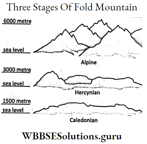
According to the geologist Fold mountains have formed in three different stages and in between two consecutive stages there is one period of quiescence.
During the Paleozoic Period:
about 400 to 500 million years back the Caledonian Folds or the mountain system was formed. The mountains of Northern Ireland, Scotland and Scandinavia belong to this group.
WBBSEClass 9 Geography Notes
During Carboniferous Period:
about 220-320 million years back the Altitude or Hercynian mountain system was formed.
The Armorican and Hercynian mountain which stand to the south of the Caledonian, the mountain in Europe and the Appalachian mountain 3000 metres in North America belong to this group.
Urals of Russia, Aravallis of India, and Tien Shan and Nan Shan of China were also formed during this period.
During the Tertiary Period About 60 Sea Level To 70 Million Years Ago The Alpine Mountain:
the system was originated. It Caledonian stands to the south of the Altitude mountain system. The Alps, Himalayas, Rockies and Andes belong to this group and are known as Young Fold Mountains.
The Caledonian and the Altitude mountain systems are known as Old Fold Mountains.
At present, they are reduced to low and isolated plateaus due to denudation. Example. the Caledonian mountains of Europe.
Origin Of Volcanic Mountains
Ejection of magma on the earth’s surface through the fractures called vents, results in the accumulation of lava, ash and dust.
Eventually, this accumulation of lava around the vent grows into a mountain called a Volcanic mountain or a Volcano. These are also known as the Mountain of accumulation.
WBBSE Geography Notes Pdf
Example. Fujiama in Japan, Vesuvius in Italy, Mauna Loa (Highest in the world) in Hawaii island, and Barren and Narcondam in the Andaman-Nicobar islands of India.

Most of the volcanoes of the world are located along plate boundaries. Converging, diverging and neutral all three plate boundaries are separated by fault lines which are geologically very weak.
Excessive heat generated in the earth’s interior due to friction of plates melts rock. Huge gas is also formed which is also responsible for gushing out of magma through these weak zones.
Example. there is a string of volcanoes along the margin of the Pacific Oceanic plate.
Chapter 4 Geomorphic Processes And Landforms Of The Earth Features Of Volcanic Mountains
Based on the nature of the eruption Volcanic mountains are of three types. Active volcanoes are those which erupt in recent times. Again, these are of two types.
Active volcanoes with continuous eruptions are known as Incessant. Example. Vesuvius in Italy. Intermittent volcanoes are those when that erupt after a period of silence, for Example. Barren in India.
WBBSE Geography Notes Pdf
Volcanoes with signs of possible eruption in future are said to be Dormant, for Example. Mt. Fuji in Japan. Extinct volcanoes are those which erupted in pre-historic times without any hope of future eruption Example. Narcondam in India.

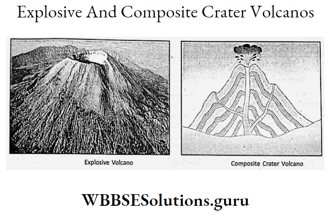
Based on shape and structure, volcanoes are of four types. Cone-shaped volcanoes are conical in shape Example. Mt. Fuji in Japan. Dome-shaped volcanoes are found in Hawaii island.
Volcanoes with explosive craters are found in Iceland. Volcanoes with Composite craters are those which have secondary craters besides the main one, e.g. Popacatapetl in Mexico.
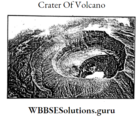
Volcanoes are generally conical in shape with steep slopes. At the top is found the crater or mouth. Bigger ones have more than one crater. Crater is connected by a vent to the magma chamber.
Origin And Features Of Block Mountains
Compressive and tensional forces produced by earth movements are responsible for the formation of cracks, or fractures when
applied on hard rocks.
This fracture is called Fault. As a result, rocks are displaced relative to one another on either side of this fault. The line along which this displacement of blocks of rocks takes place is called the Fault line.
WBBSE Geography Notes Pdf
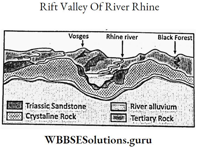
Relatively raised blocks are called Block mountains or Fault mountains. Example. Satpura in Central India. Vosges in France, the Black Forest in Germany.

Block mountains originated in four ways. When a block of rock between two parallel fault lines is raised, upthrust causes the formation of the Block Mountains.
Example. Satpura. When a block of land in between two parallel fault lines subsides, down-thrust forms Block mountains on either side of the subsided block. Example. Vosges in France, the Black Forest in Germany.
Class 9 Geography Chapter 4 Solutions
When a block of land in between two parallel fault lines is raised but tilted, develops block mountains Example. Western Ghats of Southern India.
When two sides of parallel fault lines of an extensive plateau subside in relation to the central part it stands as Block Mountain.
Characteristics Of Block Mountain :
Block mountains are flat-topped with steep slopes. They are not as lofty as the Fold mountains nor do they stretch for a vast area. They are usually accompanied by Rift Valleys. Rapids and Waterfall are common along their steep slopes.
Chapter 4 Geomorphic Processes And Landforms Of The Earth Origin And Features Of Relict Mountains
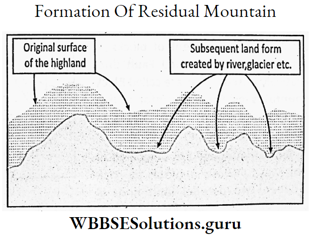
Denudation of highlands develops low mountains known as Relict or Residual mountains. They are also known as the mountain of Degradation. Example. Appalachians of the U.S.A., the Urals in Russia, and Aravallis in India.
Prolonged erosion by exogenetic forces like rivers, glaciers, wind, sunshine etc.
May reduce any pre-existing mountains like Fold, Fault or Volcanic into low heights of the mountain with soft rocks being quickly eroded, while hard rocks stand as Relict or Residual mountains.
Old Fold mountains which have reduced to Relict mountains are Aravallis, Urals, Appalachian etc. Old plateaus also have turned into Relict mountains, such as Mahadeo and Maikal mountains in India.
Relict mountains have rounded tops with gentle slopes. They are not lofty. They are made of ancient rocks and are, therefore, stable. They are less rugged with wide river valleys.
Importance Of Mountains
Mountains have great positive influences. The existence of mountains controls the climate. Example. The Himalayas obstruct the cold winds to enter India while giving rain by obstructing moist southwest monsoon wind.
Mountains are the source of big rivers like the Ganges, Indus and Brahmaputra. They help in the formation of extensive plains developed by the rivers that originated on their peaks. Mountainland is ideal for hydel power.
They help as well by protecting a country from foreign invasion. Mountains are rich in forest resources. Scenic beauties of the mountain land develop Tourism.
Class 9 Geography Chapter 4 Solutions
Mountains also affect adversely. As they are rugged, they do not favour agriculture. Mountainlands are also difficult to construct roadways as they are rocky and stony.
Mountains are sparsely populated. Mining is limited due to inaccessibility. Industries are also lacking.
Chapter 4 Geomorphic Processes And Landforms Of The Earth Plateau
Plateaus-Their Types:
Plateaus are steep-sided, flat-topped highlands with elevations, generally, varying between 300 and 600 m above sea level. Example. Plateau of Tibet, Brazilian plateau, Chotanagpur plateau etc.
Plateaus are extensive uplands. The top of a plateau is either flat or undulating. They are steep-sided and appear like tables. So they are also known as ‘Table land’.
Their height varies between 300 and 600 m above sea level. They have low relief. They may be old like the Deccan Plateau and young like the Tibetan Plateau. Old plateaus are resistant to erosion and are known as Shield.

Plateaus are formed in three ways tectonics, erosion and deposition. During earth movements ancient landmasses were broken into separate plateaus, for Example. Deccan plateau, Arabian plateau.
Plateaus are also formed due to earth movements during the formation of Fold mountains, for Example. Intermontane Tibetan plateau.
During earth, movements upthrusted tilted Block may stand as a plateau. Dissected plateaus are formed by the erosion of high plateaus by rivers, glaciers, wind etc. Example. Chotanagpur plateau.
Plateaus are also formed by the deposition of Lava. Example. Lava Plateau or Deccan Trap of Maharashtra.

Intermontane Plateau
Due to earth movement, during the formation of Fold Mountain, plateaus are formed. These plateaus are actually enclosed by the Fold Mountains.
So they are called ‘Intermontane plateau which means ‘between mountains’. Example. The Tibetan plateau is enclosed by the Kunlun in the north and Karakoram in the south.
Class 9 Geography Chapter 4 Solutions
The Plateau of Iraq lies between Elburz in the north and Zagros in the south. The plateau of Anatolia in Turkey lies between the Pontic in the north and Tauras in the south.
Columbia and Yukon plateau of the north. America and the Bolivian plateau of South America have also formed this way.

Characteristics:
Intermontane plateaus are high and found in the young fold mountain region. It occupies an extensive area. Fossils are found in the plateaus. The climate is dry as they are surrounded by mountains.
Continental Plateau
Due to the earth’s movement, the ancient landmasses of the earth were broken and separated to form Continental blocks. These are Continental Shield.
Example.Deccan plateau of India, Siberian highland of Russia, Arabian plateau, African plateau, West Australian plateau, Brazilian highland, Canadian shield or Laurentian plateau.
Characteristics:
Continental plateaus are mostly made of ancient granite and Igneisses which are more than 1000 million years old. Mostly they have turned into Low plateaus.
Structurally, they are stable. Earth movements have no effects on them. Ancient igneous and metamorphic rocks of these plateaus are rich in minerals.
Dissected Plateau
Natural agents like rivers, glaciers, and wind through their continual process of weathering and erosion reduce an extensive high plateau into smaller blocks of the plateau with irregular surfaces.
In humid regions, a plateau, intersected by deep narrow river valleys is described as Dissected Plateau. Example. Chotanagpur plateau of India, Malnad of Karnataka, Baghelkhand and Bundelkhand of Central India etc.

Characteristics :
plateaus are of low heights. Plateaus are associated with accordant hills and intervened with wide river valleys. They are reducing in height due to erosion and are rich in minerals as they are made of ancient rocks.
Lava Or Volcanic Plateau
The horizontal flow of lava gushes out from the earth’s interior through fissure eruption and spreads over the land surface in great thickness and solidifies to form a Lava or Volcanic plateau.
WBBSE Class 9 Geography And Environment Notes
Example. Deccan Trap of Maharashtra in India, Columbia-Snake plateau of the U.S.A. Ethiopian plateau of East Africa, the Parana plateau of South America.

Characteristics:
Lava plateaus are made of basalts. They are flat-topped. Occasionally they form steps at the margins. They are black in colour due to the presence of basalt rock.
Importance Of Plateaus
Most of the ancient plateaus are rich in minerals. Example. Deccan Plateau, Chotanagpur Plateau, Canadian Shield etc. So, mineral-based industries have developed on these plateaus.
Plateaus are rugged and stony, so, they do not favour agriculture but are favourable for hydel power generation. Life is easier here than in the mountains. So, the population is moderate.
Chapter 4 Geomorphic Processes And Landforms Of The Earth Plains
Plains-Their Types:
A plan is a lowland, either levelled undulating or gently sloping with its height below 300 m above sea level. Example. the Ganga Plain in North India.
Most of the plains cover an extensive area. Their height above sea level varies between 5 to 300 m. They are mostly flat with a gentle slope. Relative height is less.
Mostly they develop along the river valleys and along the coasts. Sometimes they develop surrounding a lake. Structurally they are stable.
According to the origin, plains are of three types-Depositional, Erosional and Tectonic or Structural.

Depositional Plains
Alluvial Plain:
Deposition of silt and sand by a river develops an Alluvial plain. These plains are of two types-Flood plain and Deltaic plain.
Flood Plain :
In the rainy season, the river floods its countryside repeatedly. As a result of, the deposition of sand, silt develops a thick plain called a Flood plain.
WBBSEClass 9 Geography Notes
Example. The flood plain of the river Ganga in the middle and lower courses and the flood plain of Brahmaputra valley in Assam. The flood plain of the River Nile in Egypt.
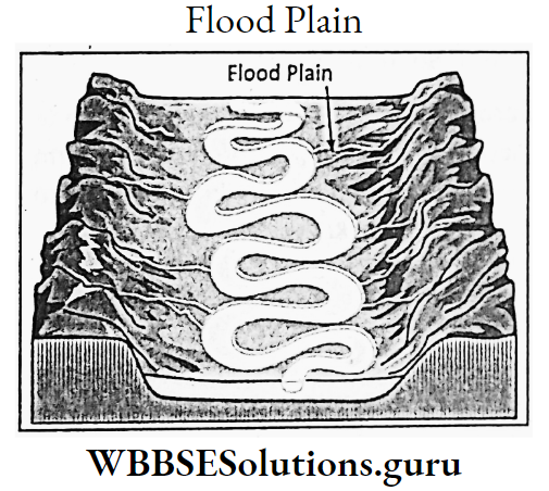
Characteristics:
In flood plains, every year new alluvium is deposited. Flood plains are usually monotonous flat land excepting the natural levees along the river banks.
The slope of the land is insignificant so, marshes and oxbow lakes are common features. New alluvium is deposited along the river sides while away from the river, old alluvium is found.
Deltaic Plain
At the mouth of a river, silts carried by a river are deposited to form a triangular plain land which looks like the fourth letter of the Greek Alphabet, ‘A’ (delta).
This plan is known as the Deltaic Plain, Example. The Ganga-Brahmaputra Delta is the largest delta in the world.
After crossing a long distance, the river deposits its load i.e. silts and sands at its mouth as the slope of land gradually ceases.
The river is divided and subdivided into innumerable branches or channels to form a delta, which eventually becomes larger and extends landwards to form a deltaic plain.

Characteristics:
The Deltaic plain is crisscrossed with innumerable river channels. The soil may be saline. Natural levees a reformed along the river valleys. River valley becomes shallow and the drainage is obstructed.
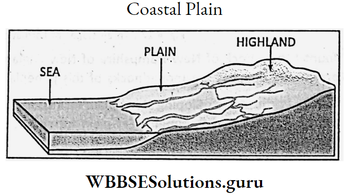
Coastal Plain
Coastal plains are mainly formed by the depositional work of sea waves. Waves and winds often deposit mud, sand, and silt along the coastline to form a Coastal plain, for Example. Palestine plain.
Parts of East and West Coastal plains of India. Coastal plains are, usually narrow (Western coastal plain of India). They. also may be wide (Eastern coastal plain of India), Sand and salts are excessively found in soils.
Slopes are gentle. Lakes, lagoons, kayaks and sand dunes are common.
Glacial Plain :
As the glacier descends down the slope of a mountain it melts at the foothills of the mountain where glacial-originated sands and gravels are deposited to form a plain land called a Glacial Plain.
WBBSEClass 9 Geography Notes
Example.Ladakh Valley in Kashmir and the South-Central part of Canada. Glacial plains are made of unassorted pebbles, stones and sands. It takes a long time to develop plain land.
Lacustrine Plain:
When a river empties into a lake its sands and silts are deposited in that lake. As a result, a portion of the lake is turned into a plain land known as Lacustrine Plain.
Example.Parts of Dal Lake in Kashmir. Imphal Valley has formed in Loktak Lake in Manipur.
Loess Plain :
Fine sand particles transported by the wind from a desert, when dropped at a distant place, gradually accumulate there to form a thick plain called Loess plain.
The best example is the loess plain formed along the Hwang Ho river valley in China where sands are carried away from the Gobi desert and are deposited by wind. Loess plain also has developed in the southern part of Israel.
Erosional Plains:
Natural agents like rivers, glaciers, and wind reduce a highland, through a long time of erosional work, into low plain lands, such as Peneplain, and Pediment.
Peneplain:
An ancient highland when reduced to plain land through denudation i.e. long continued erosion by either river, glacier or wind is known as Peneplain.
The plain is scattered with isolated hills of hard rocks known as Monadnocks, the name is coined from the Mount Monadnock of New Hampshire of New England.
Example. parts of the Chotanagpur plateau. Pareshnath and Panchet are monadnocks of this peneplain.

Pediment:
A sloping stony plain formed at the foot of a mountain produced by wind abrasion is known as Pediment. Example. plain formed at the foothills of the Atlas mountain in the Sahara desert.
WBBSEClass 9 Geography Notes
Tectonic Or Structural Plains
Plains which are formed due to earth movement are known as structural plains. They are also structurally or naturally plain land.
Structural Plain :
Without any earth movement, where sedimentary rock layers are arranged one above another for a long period of time an extensive plain land may develop. This is known as a Structural plain. Example. Siberian plain.
Chapter 4 Geomorphic Processes And Landforms Of The Earth Emerged Or Submerged Plain
Earth movement may form Emerged and Submerged coastal plains. The continental shelf may be uplifted from the sea bed.
Thus wide emerged coastal plains are formed, for Example. The coastal plain of the Gulf of Mexico. The coastal margin may also subside to form submerged coastal plains which are narrow, for Example. Turan basin.
Importance Of Plains:
Most of the plains of the world are fertile. As such, they are favourable for cultivation.
The Gangetic Plain of India, the Yangtze kiang valley of China, the Mississippi Plain of the U.S.A., and the Po Valley of Italy are the best agricultural land in the world.
A good network of transport systems has developed through roadways, railways and waterways. As a result, the plains are well-communicated and help in the development of industries and trade and commerce.
Therefore, plains are densely settled areas of the world. Metropolis like Delhi, Kolkata, Mumbai, London, and Paris have developed on the plains.
The plains have developed ancient civilisations also, such as the Egyptian civilisation, Indus civilisation, Chinese civilisation etc.