WBBSE Chapter 5 India Introduction
Geographical Location:
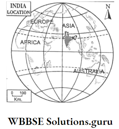
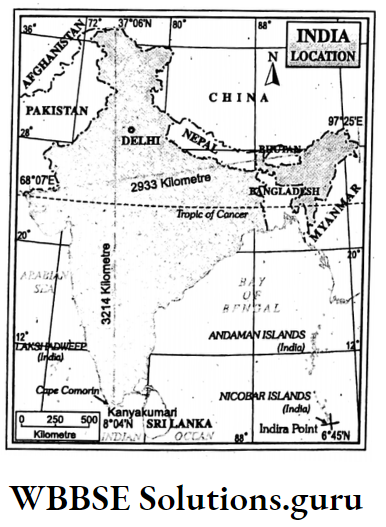
India is located in Northern Hemisphere to the southern part of the continent of Asia.
Latitude
According to latitude, the mainland of India stretches from 8°04′ north latitude(Kanniyakumari or Cape of Comorin) in the south to 37°06′ north latitude (Indira Kol in the northern extremity of Kashmir).
But the southernmost point of the Indian landmass (Indian Union) is Indira Point which was previously known as Persons Pygmalion.
It is, actually, the southernmost point of Car Nicobar where it touches the parallel of 6°45′ north.
Read And Learn Also WBBSE Notes For Class 10 Geography And Environment
Longitude
In the Eastern Hemisphere, India stretches from 68°07′ east longitude (Ghormota in the western extremity of Gujarat).
In the West to 97°25′ east longitude (Kibitu in the eastern frontier of Arunachal Pradesh) in the east.
Class 10 Geography And Environment Chapter 5 Solutions
Tropic Of Cancer
23% north latitude passes through the middle of India, thus, dividing India into two parts-North India and South India.
So, South India belongs to the Tropical belt and North India belongs to Sub-tropical and Temperate belt. 80° East longitude divides India into East India and West India.
In general, India stretches for 29° latitudes and 29° longitudes.
Extent Of India
India stretches for nearly 3214 Km in north-south extent while India is extended east-west for nearly 2933 km.
The land boundary of India is nearly 15,200 km and the length of the coastline is (including the mainland, Lakshadweep and Andaman-Nicobar islands) about 7517 km.
Boundaries Of India
India is bordered on the north by China, Nepal and Bhutan; on the west by Pakistan and the Arabian Sea, North-west by Afghanistan; on the east by Myanmar, Bangladesh and the Bay of Bengal and on the south by the Indian Ocean.
Contextually, it is to be noted that, to the south of India is Srilanka the island country which is located to the other side of the Palk strait and Gulf of Manner.
WBBSE Chapter 5 India Brief History Of Demarcation Of Provinces Of India After Independence
After nearly 200 years of British rule, India became independent on 15th August 1947. Before independence, there were 562 princely states and 9 British Provinces in India.
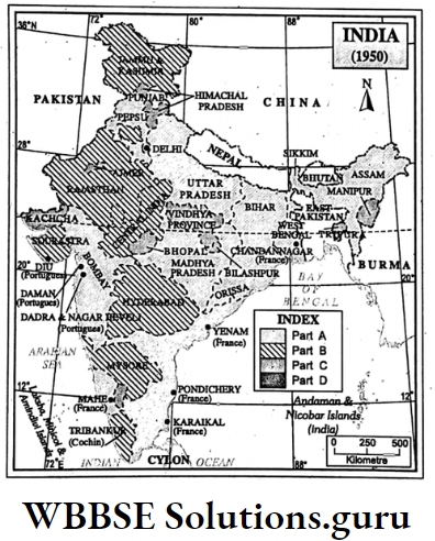
India was split into two Dominious-India and Pakistan. India became the Sovereign Democratic Republic on January 26, 1950, when it was divided into 20 states which were followed by the newly framed ‘Indian Constitution’.
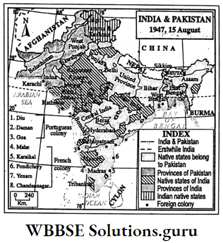
Those states were classified as
- Part-1, states under Governor’s rule include West Bengal, Assam, Bihar, Orissa, Uttar Pradesh, Madhya Pradesh, Bombay, Madras, Punjab (9 states),
- Part-2, states ruled by native states include Hyderabad, Madhya Pradesh, Mysore, Patiala and East Punjab Union, Jammu and Kashmir, Rajasthan, Saurashtra, Tribancore- Cochin (8 states),
- Part-3, states ruled by chief commissioners include Ajmer, Bhopal, Bilaspur, Himachal Pradesh, Kutch, Kurg, Delhi, Manipur, Tripura and Vindhya Pradesh (10 states).
- Part-4, states under Central rule, include Andaman and Nicobar Islands (1 state). But a demand for linguistic states had been raised since then.
Class 10 Geography And Environment Chapter 5 Solutions
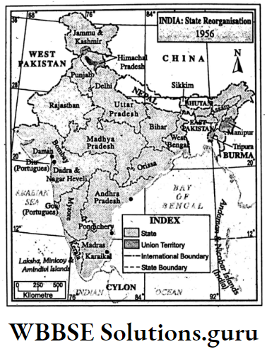
WBBSE Chapter 5 India State Reorganisation On Linguistic Basis In 1956
The government of India has formed State Reorganisation Commission in December 1953.
Accordingly, State Reorganisation Act was passed on 1st November 1956 and the Government of India reconstructed the states of India into 14 states and 6 Union territories.
States :
- Andhra Pradesh (Telegu),
- Assam (Asamia),
- Orissa (Oria),
- Uttar Pradesh (Hindi),
- Kerala (Malayalam),
- Jammu and Kashmir (Kashmiri),
- West Bengal (Bengali),
- Punjab (Punjabi),
- Bihar (Hindi),
- Bombay (Marathi and Gujarathi),
- Madhya Pradesh (Hindi),
- Mysore (Kanari),
- Madras (Tamil) and
- Rajasthan (Rajasthani)
Union Territories:
- Tripura,
- Andaman Nicobar Islands,
- Delhi,
- Lakshadweep,
- Manipur and
- Himachal Pradesh.
WBBSE Chapter 5 India State Reorganisation In Later Period
After 1956, the succeeding state reconstructions other than linguistic basis are as follows:
- 4 Union territories were formed out of Assam between 1957 and 1972
- North-eastern Frontier,
- Nagaland in 1957,
- Meghalaya in 1970,
- Mizoram in 1972,
- In 1960 the state of Bombay was split into two-Maharastra and Gujarat,
- In 1961 Portuguese colonies, namely Goa, Daman, and Diu were included. Union Territories.
- In 1963, Nagaland became a state.
- In 1966, Punjab was split into two states Punjab and Haryana and one Union Territory of Chandigarh.
- In 1971, Himachal Pradesh got statehood.
- In 1972, Tripura, Manipur and Meghalaya also achieved statehood.
- In 1975, Sikkim was included as a state.
- In 1987, Mizoram and Arunachal Pradesh got statehood, Goa also became a state.
- In 1993, Delhi was recognised as National Capital Territory.
- In 2000, Chhattisgarh was separated from Madhya Pradesh, Uttaranchal (Uttarakhand) was separated from Uttar Pradesh and Jharkhand was separated
- from Bihar.
- On 2nd June 2014, Andhra Pradesh was divided into two states-Andhra Pradesh and Telangana. So, Telangana at present is the youngest state in India.
WBBSE Chapter 5 India Existing States And Union Territories In India
In India, at present, there are 29 States and 7 Union Territories.
States:
- West Bengal,
- Arunachal Pradesh,
- Madhya Pradesh,
- Kerala,
- Odisha,
- Nagaland,
- Jammu and Kashmir,
- Chhattisgarh,
- Bihar,
- Sikkim,
- Gujarat,
- Assam,
- Uttarakhand,
- Uttar Pradesh,
- Maharastra,
- Jharkhand
- Meghalaya,
- Himachal Pradesh,
- Goa,
- Manipur,
- Telangana,
- Punjab,
- Karnataka,
- Mizoram,
- Haryana,
- Andhra Pradesh,
- Tripura,
- Rajasthan,
- Tamilnadu.
Union Territories:
- Delhi (National Capital Territory),
- Chandigarh,
- Puducherry,
- Dadra and Nagar Haveli,
- Andaman and Nicobar,
- Lakshadweep and
- Daman and Diu.

Class 10 Geography And Environment Chapter 5 Solutions
WBBSE Chapter 5 India’s Physical Environment
India, our motherland, occupies a strategic position in Asia in respect of diversified relief, climate, soil, natural vegetation, minerals etc.
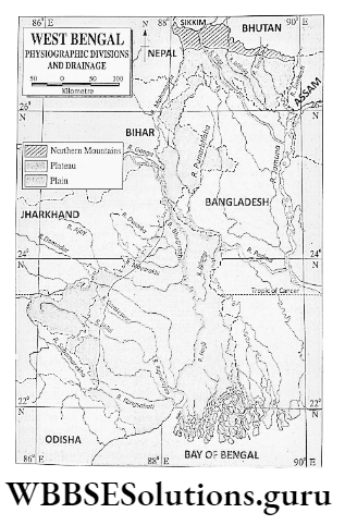
Physiographic Divisions Of India:
Physiographically, India can be divided into five regions
- The Northern Mountainous Region,
- The Great Northern Plains,
- The Peninsular Plateau,
- The Coastal Plains and
- The Islands.
The Northern Mountainous Region :
the Northern Mountainous Region consists of
- The Himalayas,
- The Ladakh and
- The Karakoram Range and
- North-eastern Mountain or Purbachal.
The Himalayas
Originating from the Pamir Knot, the Himalayas stretches in a crescent shape to the extreme north of India.
It stretches for nearly 2500 km with a width of 150 km to 400 km from Nanga Parbat (8126 m) in Kashmir in the west to Namcha Barwa (7755m) in Arunachal Pradesh in the east.
The Ladakh Range
To the north of the Himalayas stands the Ladakh range stretching for about 350 km. with many peaks above 6000 m.
To the northeast of it lies the Ladakh plateau which is the highest (above 4000 m) and cold plateau of India and originated from the Tethys Sea.
Class 10 Geography Chapter 5 WBBSE Solutions
Karakoram Range
Further north of the Ladakh range stands the Karakoram range. It stretches for nearly 400 km with many peaks above 8000 m.
Godwin Austen or K2 (8611m), the highest peak of India lies here. It also originated from the Tethys Sea together with the Himalayas and the Ladakh ranges.
Siachen, the longest glacier (76 km) in India belongs to this range. Baltaro and Rimo are also famous glaciers that belong to this range.

Class 10 Geography Chapter 5 Question Answers
WBBSE Chapter 5 India Account Of The Himalayas
Parallel ranges Four phases of intensive earth movements caused the upliftment of four east-west extended parallel ranges. From the north to south are
1. Tethys or the Tibetan Himalayas:
which lies in the extreme north of India. It merges with the Tibetan plateau with an average height of 5500-6000 m, most of which lies in China. It was uplifted about 7 crores years back.
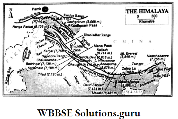
2. Himadri or the Great Himalayas:
It stands to the south of the Tethys Himalayas and consists of lofty snowcapped peaks with an average height of 6000 m. Mt.Everest, the highest (8848 m) peak in the world belongs to this range.
It also includes lofty peaks, namely Kanchenjungha, Nandadevi, Annapurna, Dhaulagiri etc. Kanchenjungha is the highest (8598 m) peak of the Himalayas located in India.
It also originated during the first phase of upliftment together with the Tethys Himalayas.
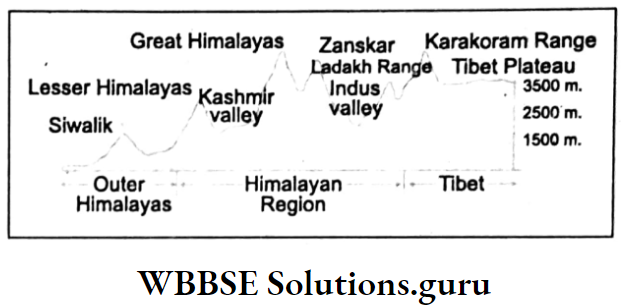
3. Himachal or the Lesser Himalayas:
To the south of the Himadri stands the Himachal or the Lesser Himalayas. With height varying between 2000 and 3000 m.
It consists of Mussourie, Nagtibba, Pirpanjal, and Dhaoladhar peaks. It originated during the 2nd phase of upliftment of the Himalayas about 2 crore years back.
4. Siwalik or the Sub-Himalayas:
About 30 lakh years back during the third phase of upliftment of the Himalayas the Tethys, Himadri and Himachal were again uplifted. It is 10-15 km wide with an average height varying between 600-1500 m.
Mussourie, Jammu, and Dafla ranges are located here
WBBSE Chapter 5 India Regional Divisions Of The Himalayas
On the basis of regional characteristics the Himalayas can be divided into three sub-regions
- The Western Himalayas,
- The Central Himalayas (belongs to Nepal) and
- The Eastern Himalayas. Central Himalayas in Nepal includes the lofty peaks of Mt. Everest, Dhaulagiri, Annapurna etc.
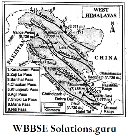
The Western Himalayas
It May Be Subdivided Into Three Regions :
1. The Kashmir Himalayas:
It belongs to the state of Jammu and Kashmir. To the extreme south stands the Jammu and Punch Hills. Further north is the Pirpanjal range.
To the north of Pirpanjal lies the famous Kashmir valley which is bordered on the north by the Himadri and Zanskar ranges. Further north lies the Indus Gorge.
Class 10 Geography Chapter 5 Question Answers
To the extreme north stands the Karakoram range. Godwin, Austen or K2, the highest peak of the Karakoram range belongs to India.
2. Himachal Pradesh Himalayas:
It belongs to the state of Himachal Pradesh. To the extreme south stands the Siwalik range. Further north stands the Lesser Himalayan ranges, namely Dhaoladhar, Pirpanjal, Nagtibba and Mussourie.
3. Kumaon or Uttarakhand Himalayas:
It belongs to the state of Uttarakhand to the extreme south are found a few famous valleys or duns, namely Dehra Dun, Choukhamba etc.
To the north of these valleys stand the Nagtibba and Mussourie ranges. Further north are found lofty snow-capped peaks, such as Nandadevi (7817 m), Gangotri (6114 m), Kedarnath (7188 m) etc.
The Eastern Himalayas
It can be divided into three sub-regions:
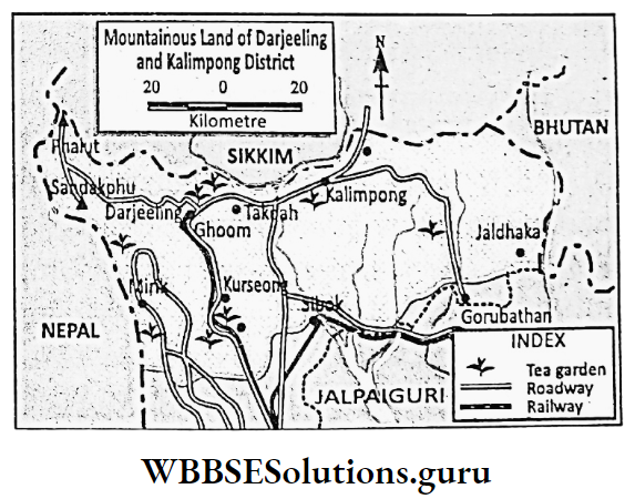
Sikkim:
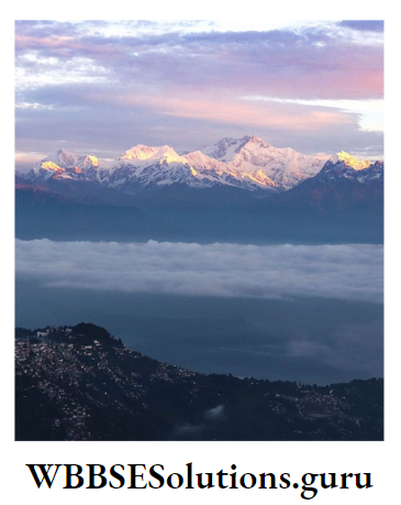
Darjeeling Himalayas-There is three important ranges, namely Singalila, Dawhill and Dongkia. Kanchenjungha (8598 m), the third highest peak of the world belongs to Sikkim Himalaya and this is the highest peak of the Himalayas in India.
Bhutan Himalayas:
The topography of this region is very much rugged. Kula Kangri (7554 m) is the highest peak in this region.
Assam Or Arunachal Himalayas:
It belongs to the state of Arunachal Pradesh. Siwalik range stands to the north of the Brahmaputra valley. Further north stands the Lesser Himalayas and to the extreme north stands the Great Himalayas.
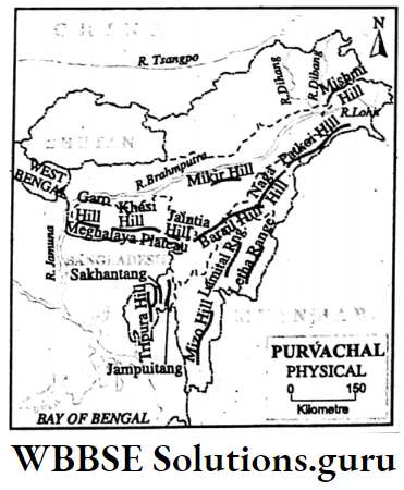
The North-Eastern Hills Or Purbachal
The Purbachal lies in North-east India extending in a north-south direction in the states of Assam, Arunachal Prades Nagaland, Manipur, Mizoram and Tripura.
There are many ranges of low heights varying between 1800 m and 4000 m. These hills are the southern continuation of the Himalayan ranges.
These are Patkoi and Mishmi in Arunachal Pradesh, and Naga hills in Nagaland, the highest peak of which is Saramati (3825 m).
Tuen sang in Manipur, and Mikir and Barail hills in Assam are connecting the Khasi-Garo-Jaintia hills of Meghalaya.
Dafabum (4579 m) of Mishmi hills of Arunachal Pradesh is the highest peak of this region.
Class 10 Geography Chapter 5 Question Answers
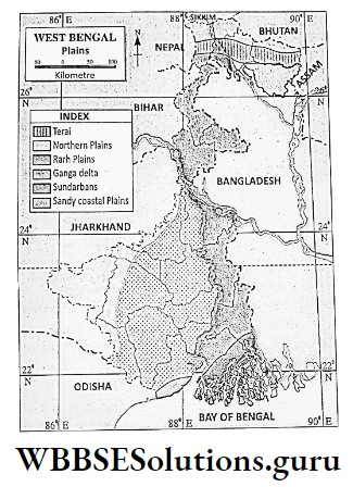
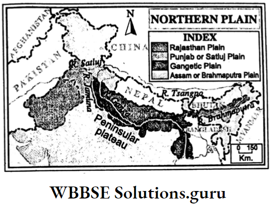
WBBSE Chapter 5 India The Plains Of Northern India
The Northern Plains are located to the south of the Himalayas and to the north of the Peninsular Plateau of India.
The plains of Punjab, Haryana, Uttar Pradesh, Bihar, West Bengal and Assam belong to this region. The Northern Plains consist of
- Rajasthan Plain,
- Punjab plain,
- The Ganga Plain and
- The Brahmaputra Valley.
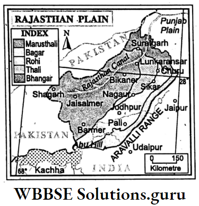
Rajasthan Plain
The southwestern part of the Northern Plain is known as the Rajasthan Plain. The region slopes from the east (325 m) to the west (150 m) and is located to the west of the Aravalli hills in the state of Rajasthan.
It is an extensively sandy plain and experiences an extreme type of climate because of which Luni, the only river in this region is saline. It is actually part of the Thar desert known as Marusthali.
There are a few saline lakes namely Panchpadra, Didwana, Sambhar etc. The dry shallow channels or lakes are called Dhand and shifting dunes are known as Dhrian.
Physiographically, the plain may be divided into five sub-divisions. To the extreme west lies the Marusthali made of sands, sand dunes and stones.
Areas made of stones are known as Hamada. To the east of Marusthali lies Bagar, the grassland along the riverside of Luni. To the east of Bagar lies Rohi which is a floodplain.
To the north of the river, Luni lies Thali the sandy region full of sand dunes.
Punjab Plain
The western part of the Northern Plain is known as Punjab Plain. It is delimited by the river Yamuna, the right bank tributary of the Ganga on the east and belongs to the states of Punjab, Haryana and Uttar Pradesh.
This plan is made of silts deposited by the river Indus and its tributaries, namely the Sutlej, Beas, Ravi, and Chenab the new alluvium deposited near the river banks of these rivers forms a plain land locally called Bet.
Class 10 Geography Chapter 5 WBBSE Solutions
The land between two rivers is known as Doab. The floodplain is locally known as Dhaya and the crowded land is known as Chaos. Old alluvium to the south of the Punjab Plain is known as Bhangar.
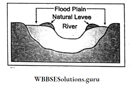
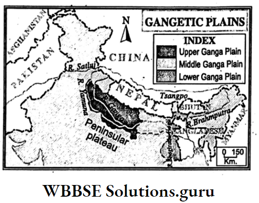
The Ganga Plain
This is an extensive plain comprising nearly 3,75,000 sq. km. area in Uttar Pradesh, Bihar and West Bengal. It is a monotonous plain scattered with hills and natural levees.
The region slopes from the west to the east and southeast. It can be divided into sub-regions
- Upper Ganga plain extends from the river Yamuna in the west to the confluence at Ganga and Yamuna near Allahabad in the east with a height of 100-250 m.
- Middle Ganga Plain stretches from Allahabad in the west to Rajmahal Hill in the east with a height of about 50-100 m.
- Lower Ganga Plain stretches from Rajmahal Hill to the Bay of Bengal with a height of 450 m above sea level. The old alluvium is away from the river, and the bank is known as Bhangar.
- Fertile new alluvium along the river bank is known as Khadar. A stony plain located to the west of this plain at the foothills of the Himalayas is known as Bhabar.
- To the south of the Bhabar is located Terai, a narrow humid region.
The Brahmaputra Valley
The eastern part of the Northern Plain in Assam made by the deposition of silts of the river Brahmaputra is the Brahmaputra valley.
This is an elongated narrow plain which is bounded by the hills on the north, east and south. The plain slopes from the east (130 m) to the west (30 m).
The river Brahmaputra flows in a braided course. There are many sandbanks and river islands in the river Brahmaputra. Majuli island, the largest river island in the world is found in this river.
The northern part of this plain laying at the foothills of the Himalayas composed of sands, stones and pebbles is called Terai.
WBBSE Chapter 5 India The Peninsular Plateau
To the south of the Northern Plains is located the Peninsular Plateau of India. Geologically, it is part of the ancient landmass of the world, the Gondwanaland.
Based on variation in landform, this plateau may be divided into three regions
- The Central Highland,
- The Eastern Highland and
- The Deccan Plateau.
The Central Highland
It covers the highlands of Rajasthan, Madhya Pradesh and Uttar Pradesh. On the Western border of Central Highland stands the Aravalli, the oldest fold mountain of India as well as of the world.
Gurusikhar (1722 m) is the highest peak of Aravalli. Vindhya, the most important range of this highland has an average elevation of 300 m and is the source of the river Chambal.
The highest peak of this range is Manpur (881 m). To the west of the Vindhya is located the Malwa plateau.
The northeastern part of the Malwa plateau is composed of pink granite and is called the Bundelkhand plateau. The eastern part of the Vindya range is known as the Rewa plateau.
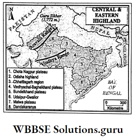
The Eastern Highland
It comprises Chota Nagpur plateau of Jharkhand, Baghelkhand plateau of Chhattisgarh, Mahanadi Basis and the plains of Chhattisgarh and Dandakaranya of Odisha.
Denudation has lowered this region. Pat, the highest (1100 m) part of the Chota Nagpur plateau lies to the west of this region. The famous Ranchi plateau dissected by the river Damodar is located to the east of the Pat region.
To the north of the river, Damodar lies the Hazaribag plateau where stands the Pareshnath hill (1366 m), the highest peak of the Chota Nagpur plateau.
To the northeastern corner of the plateau on the West Bengal-Bihar border stands the Rajmahal Hills. The Dalma, Porhat and Rajmahal hills of this region are made of basalt rock.
To the south of the Baghelkhand plateau lies the Chhattisgarh Basin of the river Mahanadi. Further south, stands the Dandakarnya hills of Odisha, the highest part of which is the Koraput.
Garjat Hills (400-1000 m) stand to the south of the Ranchi plateau.
Class 10 Geography Chapter 5 WBBSE Solutions
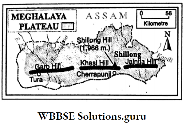
WBBSE Chapter 5 India Meghalaya Plateau
The Chota Nagpur plateau extends into the state of Meghalaya. Millions of years back, part of the old plateau lying between the Chota Nagpur plateau and the Meghalaya plateau subsided due to earth movement.
Thus Meghalaya Plateau became isolated from, the rest of the Peninsular Plateau. The subsided region was, eventually, occupied by the Ganga Plain.
Meghalaya plateau consists of Mikir hills in the east, Garo hills in the west and Khasi-Jaintia hills in the middle.
Shillong, Cherrapunji located in the central part of the plateau is the highest part of this region with an average height of 1500 m. Shillong (1966 m.) is the highest peak in this region.
The Deccan Plateau
The Deccan plateau extends from the Vindya range in the north to the Kanniyakumari (Cape of Comoris) in the south.
It is bounded on the west by the Western Ghats or Sahyadri and on the east by the Eastern Ghats or Malayadri. The plateau is part of the ancient Gondwanaland of the world.
It is composed of ancient igneous rocks like Granite and metamorphic rocks like gneiss. The region slopes from the west to the east and rises gradually to the south.
Deccan trap, an extensive part of the plateau in the northwest, is covered by black soil and is known as the lava plateau.
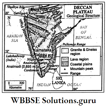
Ranges Of The Plateau
Satpura-Mahadeo range located to the south of the river Narmada is a block mountain. Its highest peak is Dhupgarh (1350 m). To the east of it stands the Maikala range.
Its highest peak is Amarkantak (1057 m). Along the western border of the Deccan plateau stands the north-south extended Western Ghats or Sahyadri.
Anaimudi (2695 m) 1500 is its highest peak which is also the highest peak in South India. Important peaks of the Western Ghats are Vavulmala (2339 m).
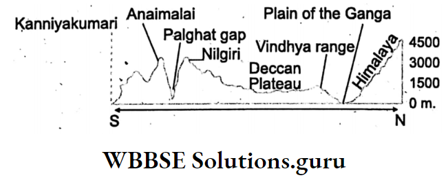
Kalsubai, Mahabaleswar etc. There are a few passes, namely Thal Ghat near Nasik and Bhor Ghat near Pune. To the extreme south of the plateau, there is the Nilgiri-Anaimalai-Palni-Cardamom range.
Dodabeta is the highest peak of Nilgiri (2637 m). To the south of Nilgiri lies the Pal Ghat gap. Further in the south stand the forested hills of Anaimalai, Palni and Cardamom.
Class 10 Geography And Environment Notes WBBSE
Actually, to the south of the Pal Ghat gap, the Western Ghats have reappeared to form Anaimalai the two branches of which are Palni to the east and Cardamom to the south.
So, Anaimudi is rightly considered the highest peak of the Western Ghats. To the east of the Deccan plateau stands the Eastern Ghats extended in a north-south direction.
Important peaks are Bilgiri Rangan, (1750 m), Armaconda and Mahendragiri.
WBBSE Chapter 5 India The Coastal Plains
The coastal plain of India stretches along the Arabian Sea coast in the west and the Bay of Bengal coast in the east. It may be broadly sub-divided into
- East Coastal Plain and
- West Coastal Plain.

East Coastal Plain
It extends from the river Subarnarekha in the north to Kanniya- Kumari in the south for nearly 1500 km. It may be divided into two division
- North Circar Coast to the north of the river Krishna including Odisha Coastal Plains in between the river Subarnarekha in the north and the river Rushikulya in the south and Andhra Coastal Plain from the mouth of Rushikulya to the lake Pulicat.
- Coromandel Coast to the south of the river Krishna is known as the Tamil Nadu coast which stretches from Lake Pulicat to Kanniyakumari.
- There are many sand dunes and lagoons in the eastern coastal plain. Sand dunes in Tamil Nadu are locally called Theris. A few lagoons, namely Chilka on the Odisha coast.
- Kolleru and Pulicat on the Andhra coast are found between the sand dunes and the coast.
West Coastal Plain
It stretches from Runn of Kachchh in the north to Kanyakumari in the south. It is much narrow than the eastern coastal plain.
It is divided into four sections
- Gujarat Coastal Plain is found in Gujarat. It includes
- Kachchh and
- Kathiwar Peninsula. Runn of Kachchh, a marshy land is located in Kachchh Peninsula. In Kathiwar Peninsular there are two forested hills-Gir and Girnar.
- Konkan Coastal Plain of Maharastra is narrow and broken. It extends from north of Maharastra to Goa, in the south.
- Karnataka Coastal Plain of Karnataka extends from Goa in the north to the south of Karnataka. It is also narrow and broken.
- Malabar Coastal Plain of Kerala is 95 km wide. There are many sand dunes (Theris) and Kayals (backwaters) like Vembaonad near Cochi (80 km long) and Austamudi near Quilon (Kollam).
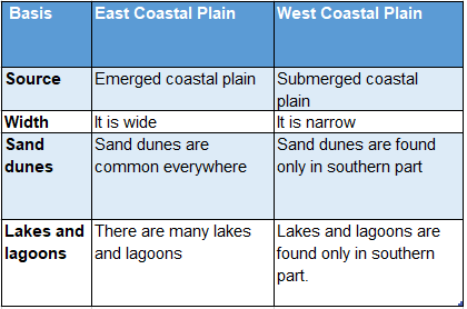
Comparison Between East And West Coastal Planes:
The Islands
The islands of India may be grouped into two divisions
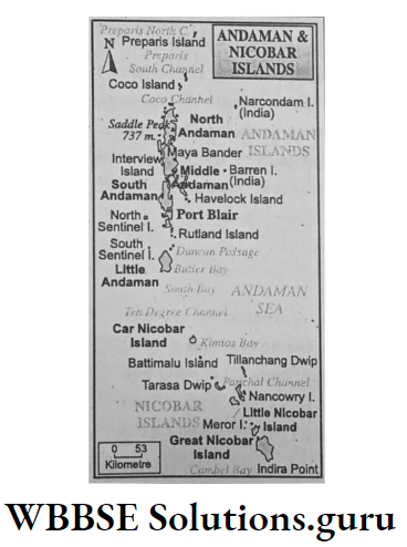
- Islands of the Bay of Bengal which include Andaman and Nicobar Islands. These are actually, the tops of the submerged mountain ranges. The highest peak is Saddle (775 m). Barren and Narcondam are two volcanic peaks.
- Islands of the Arabian Sea include Lakshadweep located off the Malabar Coast in Kerala. These are coral islands and were referred to as Laccadivi, Minicoy and Amindivi.
WBBSE Chapter 5 India Significance Of Physiographic Divisions
Importance of the Himalayas:
- Defence: The Himalayas protects India like a wall from foreign invasion.
- Climate: It prevents cold winds to enter India in winter and gives rain in summer by obstructing moist southwest monsoon wind.
- Source of the river: The Ganga, Brahmaputra, Indus and their tributaries have originated in the Himalayas.
- Fertile plain land: Himalayan rivers have brought a large number of silts and deposited them to form the great plain land of North India.
- Others: The rich coniferous fruits and medicinal herbs, extensive pasturelands, hydel power generation on turbulent rivers as well as scenic beauties of the Himalayas play an important role in the life of Indian people.
Importance Of The Plains Of Northern India:
Excepting the Marusthali on the west the rest of the Northern Plain of India is agriculturally sound. This is known as the ‘Granary of India’.
The transport system is well developed because of its flat land. It is famous for many industries like sugar, jute, cotton textile, chemical and leather. This is the most populated region of India.
Important cities like Delhi, Kolkata, and Patna are located here. The saline lakes of Marusthali are famous for the production of salt.
Importance Of The Peninsular Plateau:
The Peninsular plateau is important for mineral resources like coal, copper, and iron ore as it is an ancient plateau, Chota Nagpur plateau is known as the ‘Mineral Storehouse of India’.
River valleys are agriculturally rich. Mineral, forest and agro-industries have well developed here. Swift-flowing rivers are favourable for hydel power generation.
For scenic beauties Mt. Abu, Netarhat, and Panchmari are famous tourist spots.
Class 10 Geography And Environment Notes WBBSE
Importance Of Coastal Plain :
The coastal plain is agriculturally famous. Rice, sugarcane, spices, and coconuts grow profoundly. Fishing is an important activity. Important ports like Mumbai, Chennai, Visakhapatnam, and Cochi are located here.
Many industries like cotton textile, oil refining, chemical and engineering have developed here.
Importance Of Islands:
The Islands are fertile as well as forested but sparsely populated. So, the scenic beauties of these islands attract many tourists.
WBBSE Chapter 5 India Water Resources Of India
Water is one of the most important renewable natural resources for supporting life.
Facts at a glance :
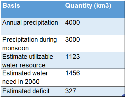
Source:
Water Resource at a Glance 2011 Report, CWC, New Delhi.
WBBSE Chapter 5 India Rivers Lakes Waterbodies And Canals
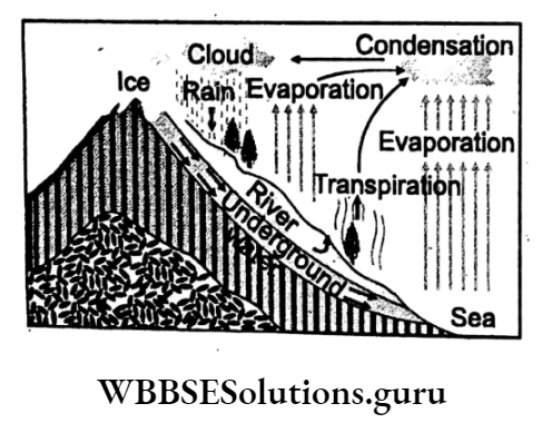
Most of the precipitation goes to sea or lakes by surface runoff i.e. Rivers.
Rivers
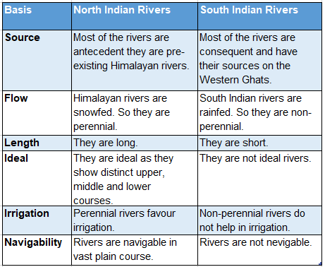
Indian rivers can be divided into two groups according to their sources, courses and mouths
- Rivers of North India and
- Rivers of South India.
Rivers of North India
The North Indian Rivers are
- The Ganga,
- The Indus and
- The Brahmaputra.
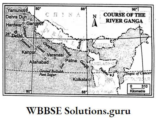
The Ganga
Ganga is the principal river of India. From source to mouth, the river can be divided into three courses-the upper course, the middle course and the lower course.
The Upper Course:
28 Delhi Bhagirathi, the source of the river Ganga, rises in the Gangotri Glacier of Gomukh ice cave in Uttarakhand. It flows southwestward to meet the river Alakananda, a tributary of the river Ganga near Devaprayag.
The combined flow known as Ganga flows through the Siwalik range southwards. At Hardwar, the river Ganga leaves the upper or mountain course.
The Middle Course:
From Hardwar, the river Ganga flows southward and turns eastward flowing through Uttar Pradesh and Bihar. Near Rajmahal hills, the river Ganga enters West Bengal.
Lower Course:
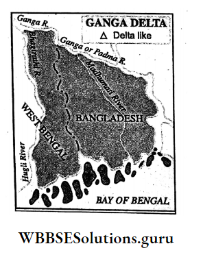
In West Bengal, the river Ganga flows eastward and near Dhulian it is divided into two distributaries
- The Padma flowing through Bangladesh and
- The Bhagirathi flows southward and is known as Hugli from Chinsura up to the mouth of the Bay of Bengal forming an estuary.
The Ganga At A Glance:
The Ganga is 2510 km long (including 2071 km in Bangladesh). It has formed the largest delta in the world. Right Bank tributaries- The Yamuna and Son.
Left Bank Tributaries:
Gomti, Ghaghara, Gandak and Kosi.
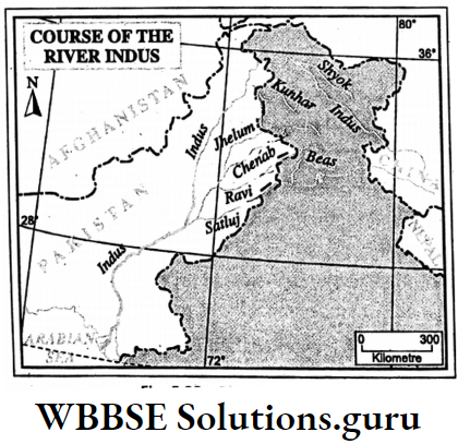
The Indus
The river rises in the Sangekhabab glacier in Tibet. It flows westward in Jammu and Kashmir between Karakoram and Ladakh ranges. Near Nanga Parbat it turns through a deep gorge and enters Pakistan.
Indus at a Glance :
The Indus is 2880 km long (only 709 km is in India) Left Bank Tributaries-Sutlej, Beas, Ravi, Chenab and Jhelum.
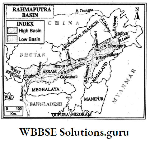
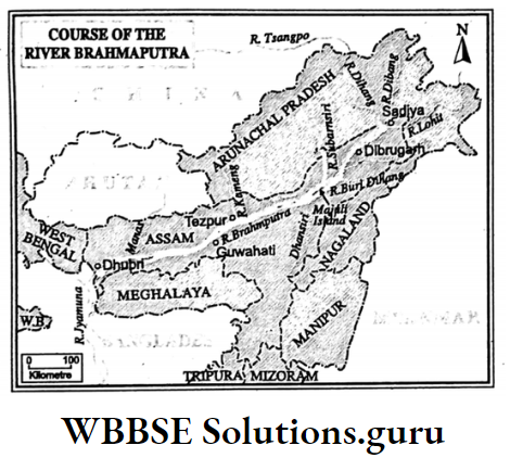
The Brahmaputra
The river Brahmaputra rises in the Chemayungdeng glacier located 90 km southeast of Rakshas Tal and Manas Sarovar in Tibet where it is known as Tsangpo.
Near Namcha Barwa peak it turns southward through a deep gorge and enters Arunachal Pradesh where it is called Dihang. The Dihang enters Assam near Sadiya and joins the Luhit and Dibang rivers.
The combined flow is known as the Brahmaputra. At Dhubri the Brahmaputra takes a southward turn and enters Bangladesh as Yamuna and finally drains into the Bay of Bengal.
Brahmaputra at a Glance :
- The Brahmaputra is 2580 km long. In India, it is about 885 km long.
- Right Bank tributaries-Subarnasiri, Manas, Sankosh.
- Left Bank tributaries-Dhansiri, Kopili, Lohit.
- The Brahmaputra has formed the world’s largest river island-Majuli.
WBBSE Chapter 5 India Rivers Of South India
In South India, the Narmada and Tapi are west-flowing rivers and Mahanadi, Godavari, Krishna, and Kaveri are important east-flowing rivers.
The Narmada (1300 Km):
It rises on the Amarkantak peak of the Maikala range and flows through a narrow rift valley between Vindhyas in the north and Satpura in the south and finally drains into the gulf of Khambat forming an estuary.
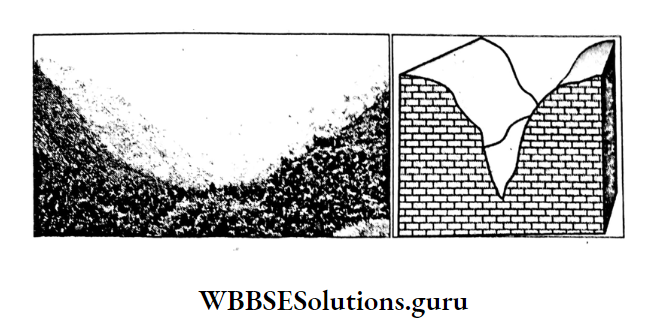
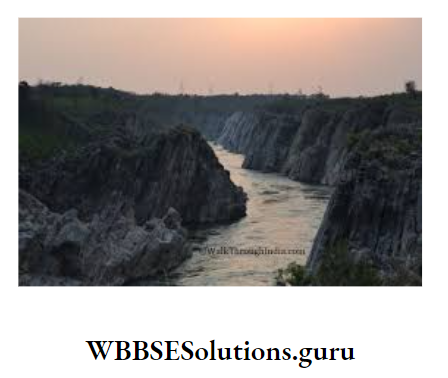
It has formed the famous Dhuandhar waterfalls on the Bheraghat marble rock region near Jabbalpur. Two important tributaries of Narmada are Kolar and Hiran. However, Narmada forms no delta.
Class 10 Geography And Environment Notes WBBSE
The Tapti Or Tapi (724 Km):
It rises near Multai on the Mahadeo range in Madhya Pradesh. It flows through a rift valley between the Satpura in the north and Ajanta in the south.
It flows westward to drain into the Gulf of Khambat forming an estuary at its mouth. Important tributaries of Tapi are Purna, Girna, Vethor etc. Tapi also forms no delta.
The Mahanadi (880 Km):
It rises on the Sihwa range in Chhattisgarh and flows eastward and drains into the Bay of Bengal forming a large delta at its mouth. The Sheonath, Brahmani and Baitarani are the important tributaries of the river Mahanadi.
The Godavari (1465 Km):
This is the most important river in South India. It rises on the Trombok hills of Sahayadri in Maharastra and flows southeastward and drains into the Bay of Bengal forming a large delta at its mouth.
Important tributaries of Godavari are Penganga, Wardha, Wainganga, Manjira, Pranhita, Indravati etc. Important distributaries are Goutami, Basistha, Bainateo etc.
The Krishna (1400 Km):
It rises on the Mahabaleshwar hills of the Western Ghats and flows eastward to drain into the Bay of Bengal forming a large delta at its mouth. The important tributaries are Koyna, Bhima, Tunga, Bhadra and Bedbati.
The Kaveri (800 Km):
It rises on the Brahmagiri hills of the Western Ghats in Karnataka and drains into the Bay of Bengal forming a large delta.
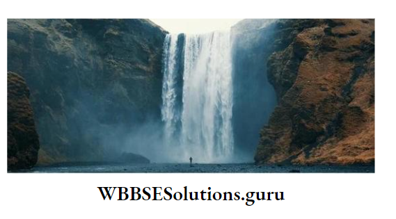
It has formed the famous Shivsamudram waterfall. Important tributaries are Bhabani, Himabati.
Comparison Between The Rivers Of North And South India:
Facts at a Glance :
- Godavari is the longest river in South India. So it is called the ‘Ganga of the South’ or ‘South Ganga’.
- Kaveri is the holy river of South India. So it is also known as the ‘Ganga of the South’ or ‘South Ganga’.
- Gersoppa or Yog is the highest waterfall (275 m) on the river Sarabati in India.
WBBSE Chapter 5 India Lakes
Many lakes are found in different parts of India. Lakes are usually natural. Man-made lakes are also found. On the basis of taste, lakes are of two types
- Fresh water lake and
- Saltwater Lake or Brackish Lake.
Fresh Water Lakes:
These are mostly Himalayan lakes, located in the upper part of the mountain. So the region is very cold and the lakes are snowed. There is also less evaporation.
All these have made freshwater lakes like Dal, and Wular in Kashmir and Punatal, Sattal, Bhimtal, and Nainital in the Kumaon region.
Class 10 Geography And Environment Notes WBBSE
Rupkund near Nanda Ghunti and Hemkund near Bhurj highlands are also freshwater lakes of the western Himalayas. Some freshwater lakes in the eastern Himalayas are Loktak in Manipur, Chhangu Lake in Sikkim etc.
Salt Water Lakes:
Most of the saltwater lakes of India are found in Rajasthan where evaporation is highest. Sambhar, Didwana, Puskar, Pachpadra of Rajasthan.
Pangong and Tso Moriri of the dry Ladakh plateau of Kashmir as well as Kolleru of Andhra Pradesh and Pulicat of Tamil Nadu are famous saltwater lakes.
Chilka on Odisha’s coast is the saltwater lagoon. Bhembonad and Austamudi are saltwater lagoons locally called Kayals.
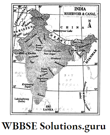
Waterbodies
There are many ponds, reservoirs, bells and tanks found in India. Important waterbodies in India are Anantnag in Jammu and Kashmir, and Indiranagar in Rajasthan.
Mirik in West Bengal, Lonar in Maharastra, Sukhna in Chandigarh and Maithan, Panchet, Govind Sagar, Rana Pratap Sagar, and Nagarjuna Sagar reservoirs.
Canals
There are many perennial canals in India, such as Upper Ganga Canal, Lower Ganga Canal, Sarada Canal and Agra Canal in Uttar Pradesh; Son Canal and Koshi Canal in Bihar.
Durgapur Canal, East Damodar Canal, Eden Canal, Bakreswar Canal and Medinipur Canal in West Bengal; Indira Canal, Chambal Canal and Bikaner Canal in Rajasthan.
- Importance of rivers, lakes, waterbodies and canals on human life.
- Rivers have formed fertile alluvial plains which are the rich farmlands of India.
- Water from rivers, lakes, water bodies and canals is widely used for irrigation.
- River water is used for hydel power generation.
- Freshwater provides drinking water.
- Navigable rivers and canals are used as waterways.
- Job opportunities are provided by production of salt, fishing and tourism.
Facts at a Glance :
- Ular in Kashmir is the largest freshwater lake in India.
- Chilka is the largest lagoon in India.
- The Indira Canal of Rajasthan is the longest canal (582 km) in India.
- Medinipur Canal is the longest (520 km) canal in West Bengal.
- Bhembanad is the largest Kayal in India.
WBBSE Chapter 5 India Means Of Irrigation
The success of agriculture mostly depends on the supply of water. In a country like India where rainfall is irregular, Irrigation is indispensable.
Means Of Irrigation :
Irrigation is practised in India
- well and tubewell,
- canal and
- irrigation.
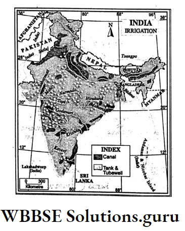
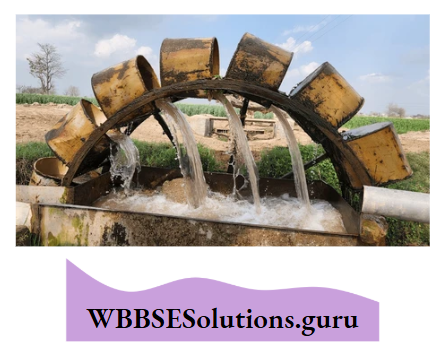
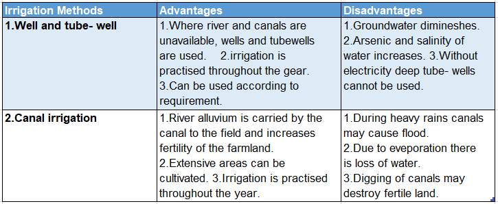
Well and Tubewell
38% of the irrigated land in India is irrigated by wells and tube wells. In this method of irrigation, wells are dug to reach the underground water table and water is lifted in two ways
- Persian wheel in which a wheel is attached by many buckets filled with water and is pulled by a rope and
- Electric pumps or diesel pumps by which irrigation is mainly practised in the plains of North India.
- Tubewells are of two types-Shallow tube wells are used in which a hand pump is used. Deep tube wells are used by electric pumps.
Wells and tube wells are mainly used in the plains of North India mainly in Uttar Pradesh, Bihar, West Bengal and Assam.
Canal
Canals are of two types
- Inundation canal and
- Perennial canal.
Inundation canals get their supply of water only when a river rises above a certain level during the rainy season.
Perennial canals carry water throughout the year as they draw their water from the perennial rivers or artificial lakes or barrages which are built across a river.
There are many perennial canals in India, such as the Upper and Lower Ganga Canal, Agra Canal, and Sarada Canal in Uttar Pradesh; Yamuna Canal and Sirhind Canal in Punjab.
Medinipur Canal, Eden Canal and canals under the river Damodar, Mayurakshi and Kangsabati project in West Bengal; Mettur Canal in Tamil Nadu.
Advantages And Disadvantages Of Well Tubewell And Canal
Overuse Of Underground Water And Its Impact
Groundwater is the main source of fresh usable water. Though the reserve of ground water is limited, yet we use and overuse it to satisfy our increasing demand in domestic, agricultural and industrial sectors. It may adversely affect.
Lowering Of Ground Water Table:
Due to the overuse of groundwater, the groundwater table is declining.
Reduction In Surface Runoff:
Due to the depletion of groundwater, there is seepage of water from rivers, lakes and other water bodies underground resulting in loss of surface water.
Landslide:
Due to overuse of underground water balance in rock layers underground is disturbed which may cause landslides.
Problem Of Salinity:
Excessive use of groundwater turns the soil into saline by the capillary.
Arsenic Pollution:
Vacuums formed underground due to over lifting water groundwater is filled with air and the oxygen present in the air mixes up with arsenic which easily.
dissolve in water and pollute the groundwater. This is rapidly increasing in some parts of West Bengal which is very much alarming.
WBBSE Chapter 5 India Multipurpose River Valley Projects
The river valley projects serve manifold benefits such as flood control, irrigation, generation of hydel powepisciculture, navigation, afforestation, control of soil erosion, supply of drinking water etc.
are known as the Multipurpose River Valley Project (MRVP). Example. Bhakra Nangal Project across the river Sutlej.
Important Multipurpose River Valley Project
Important Multipurpose River Valley Projects of India are Damodar Valley Project (Project on the river Damodar and its tributaries Barakar and Konar), Bhakra Nangal Project (Sutlej River).
Hirakund Project (Mahanadi river), Rihand Project (Rihand a tributary to Son), Nagarjuna Sagar Project (Krishna river), Tungabhadra Project (Tungabhadra, a tributary to the river Krishna).
Narmada Project (Narmada river), Kosi Project (Kosi river), Mayurakshi Project (Mayurakshi river).
Damodar Valley Corporation (D.V.C.)-A Case Study
Backdrop:
Damodar, the most important river of Chota Nagpur plateau originating from the Khamarpet hill flows through Jharkhand and West Bengal to join the river Hugli.
Many tributaries, namely Barakar, Konar, Bokaro, and Jamuria have joined this river. In the past, the river Damodar was called the ‘River of Sorrow’ because of its frequent floods.
Project
In 1948, ‘The Damodar Valley project’ was undertaken by the Central Government and Government of West Bengal and Bihar under the responsibility of Damodar Valley Corporation (D.V.C.) an autonomous body.
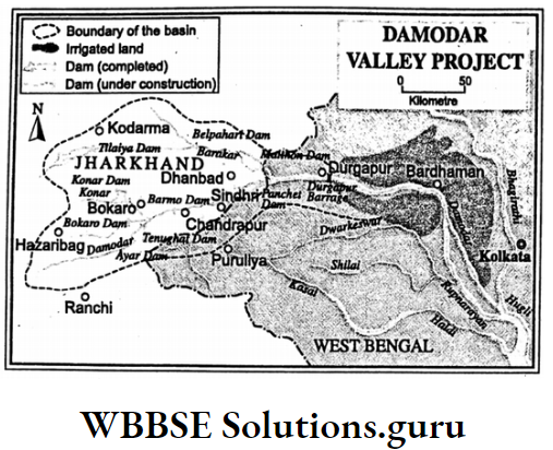
Programmes Cons:
The construction of eight dams was planned
- Panchet,
- Barmo,
- Ayre on the river Damodar;
- Maithan,
- Belpahari and
- Tilaiya on the river Barakar;
- Konar on the river Konar and
- Bokaro on the river Bokaro.
- Finally, at Tenughat, another dam was built on the river Damodar.
Implementation
Apart from the construction of dams following activities were taken up:
Electricity:
Hydel power plants at Tilaiya, Maithan and Panchet and thermal power plants at Bokaro, Chandrapura and Durgapur were set up.
Barrage And Irrigation Canal:
Durgapur barrage at Durgapur on the river Damodar was constructed. Canals on both sides were constructed for about 2495 km.
Navigation:
137 km long canal has connected Kolkata by joining Hugli river.
Impact Of The Project:
- Flood has been controlled,
- Electricity produced in this project satisfies the demand of industrial regions of Chota Nagpur, Asansol, Durgapur and Kolkata
- Farmlands of Barddhaman, Bankura, Haora, and Hugli has benefitted from irrigation water,
- Pisciculture,
- Navigation,
- Development of tourism and
- Soil conservation has materialized.
Class 10 WBBSE Geography Chapter 5 Explanation
WBBSE Chapter 5 India Conservation Of Water-Importance And Methods:
Importance :
Nearly 97% of the water resource of the world is sea or ocean water which is saline. Rest 3% is fresh water out of which 2% is polar ice.
Only 1% of water is confined to groundwater, or surface water such as rivers, ponds, beels, canals etc. Without water, life will not exist. So conservation of water is indispensable.
Methods
There are two methods of conservation of water
- Rainwater Harvesting and
- Watershed Development.
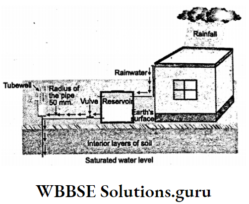
Rain Water Harvesting
To recharge groundwater reserves by storing rainwater there are different methods. In urban areas, it is possible to roof water stored in a reservoir or by sending it into an underground well.
In rural areas, rainwater flowing through rivulets and trenches may be stored in a reservoir.
Watershed Development
The Highland that separates adjacent river systems is known as a Watershed which is actually a geo-hydrological unit.
Watershed development refers to the conservation, regeneration and judicious use of all the natural resources like land, soil, water, plants, animals and human resources within the watershed area.
Objectives are to mitigate the adverse effects of drought on crops and livestock, control desertification, encourage restoration of ecological balance and promote the economic development of the village community.
Role Of Tamil Nadu In Rain Water Harvesting- A Case Study
In Tamil Nadu Rain Water Harvesting movement was launched in 2001. It has a tremendous impact on recharging groundwater tables all over Tamil Nadu.
It is mandatory to provide RWH structures in all new buildings. Out of a total of 2392457 buildings, Town Panchayats 2294342 buildings have provided RWH structures so far.
This is the outcome of the activities carried out in Town Panchayats areas to sustain the momentum of the programme.
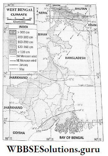
WBBSE Chapter 5 India Climate Of India
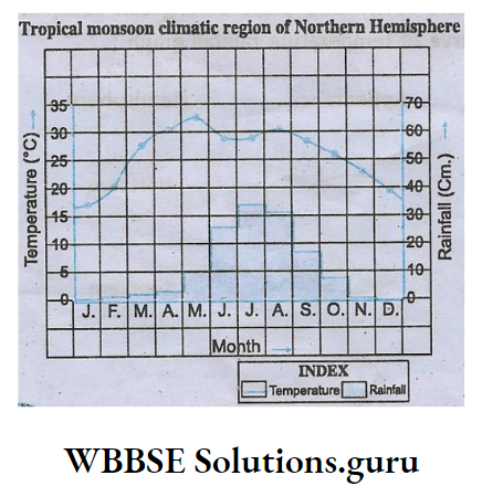
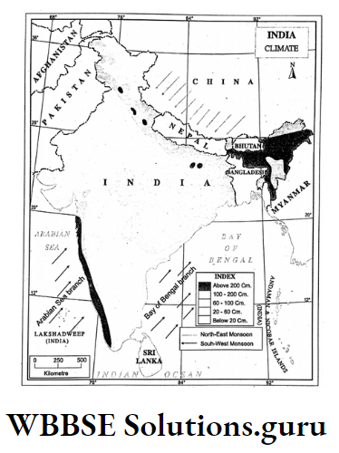
India shows great diversity in landforms. So Indian climate is very much diversified. Nevertheless, the climate of India is greatly influenced by the monsoon winds.
Regional Variation In the Climate Of India:
Cycle Of Seasons
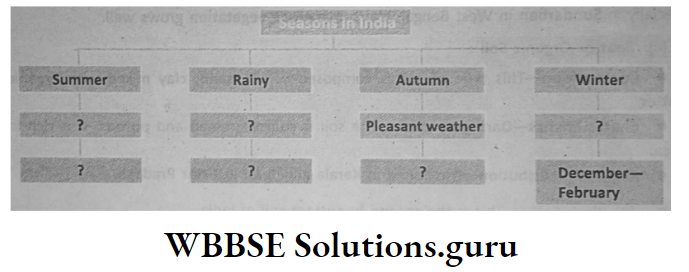
Four seasons, namely summer, rain, autumn and winter rotate in a cycle.
The Mainland of India extends from nearly 80° north latitude to about 37° north latitude.
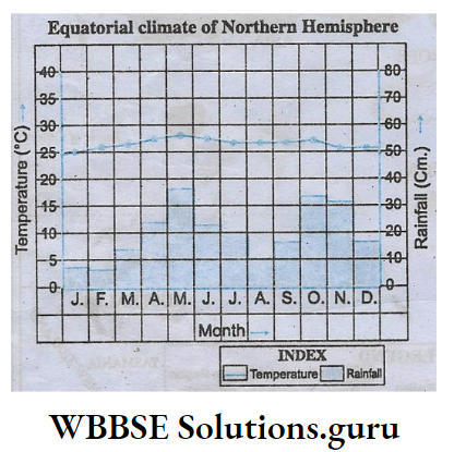
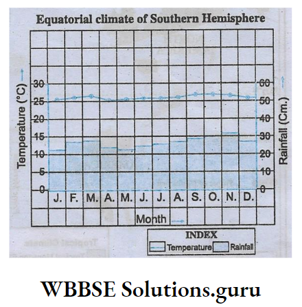
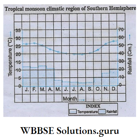
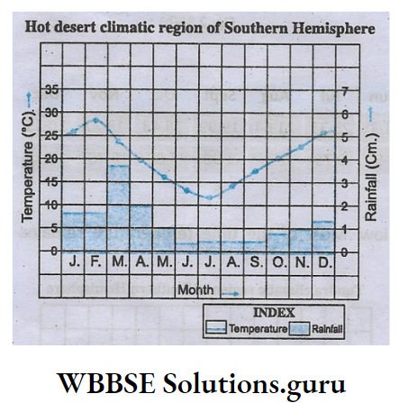
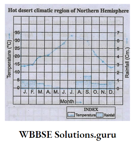
When the hot humid equatorial climate is experienced in the extreme south, the Tropical climate prevails in Central India and the Subtropical and Temperate climates prevail in Northern India.
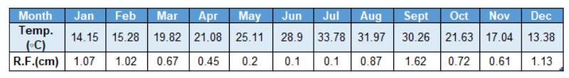
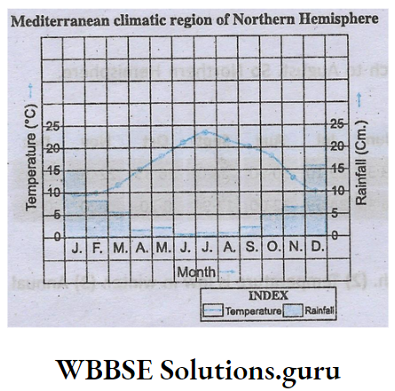
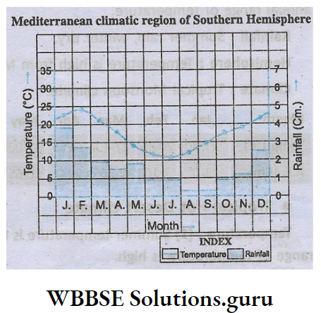
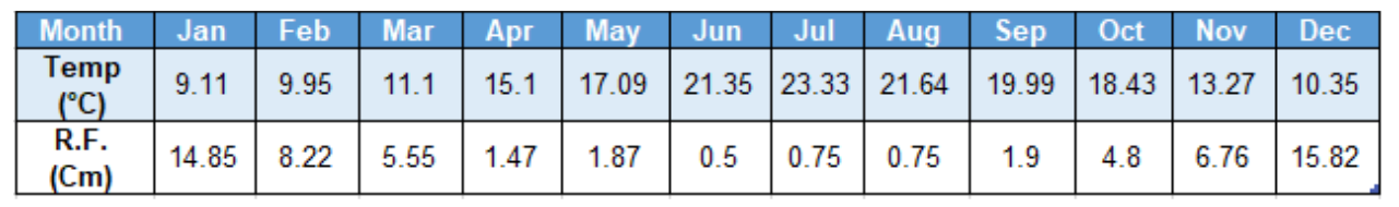
Interior of the Deccan, though not far from the sea, remains dry and the west and the East coastal Plains receive heavy rainfall due to the location of north-south extended Western Ghats and Eastern Ghats.
In Winter western Disturbances give snowfall in the mountains and rainfall in the plains. Tamil Nadu receives winter rain from the North-east Monsoon wind. The rest of India remains dry.
Being located on the same latitude climate as Darjeeling is different from that of Agra because of its altitude.
The climate of North India is extreme as it is far from the sea while the climate of South India is pleasant.
Except for North India, most parts of India enjoy mild winters.
WBBSE Chapter 5 India Factors Affecting The Climate Of India
Indian climate is largely controlled by the following factors:
Location And Latitudinal Extension:
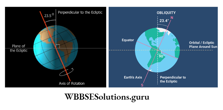
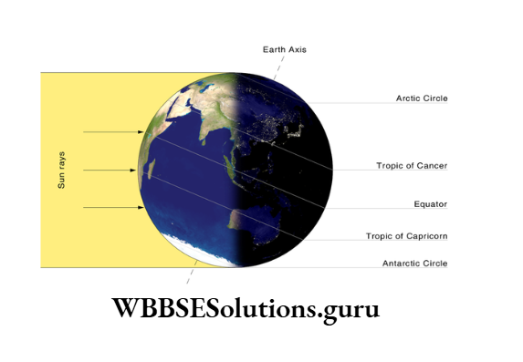
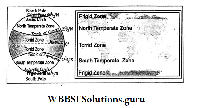
India belongs to the Torrid zone. So Indian climate is, in general, warm and humid. India extends from 8°04′ north latitude in the south to 37°06′ north latitude in the north.
The Tropic of Cancer (23°30′ north latitude) passes through the middle of the country. So, a warm Tropical climate prevails in South India and a cold or Temperate climate prevails in North India.
Class 10 WBBSE Geography Chapter 5 Explanation
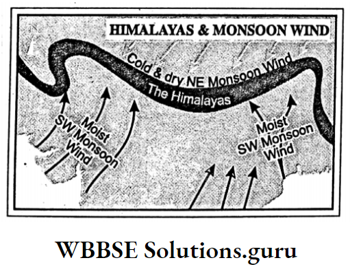
Role Of The Himalayas:
The transverse location of the Himalayas to the monsoon wind gives plenty of rain in summer and protects India from the severe cold winds in winter.
Relief :
Summers are pleasant in the mountainous regions of North and South India due to their altitude. But summers are hot in the plains and plateaus of North and South India.
Distance From The Sea:
Peninsular India as bordered on three sides by seas and oceans enjoys a maritime (moderate) climate while the interiors of north and central India experience extreme types of climate.
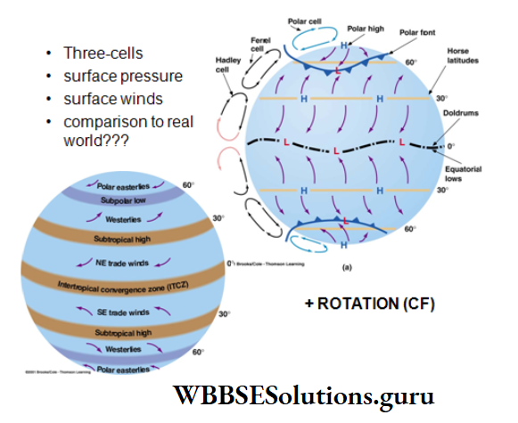
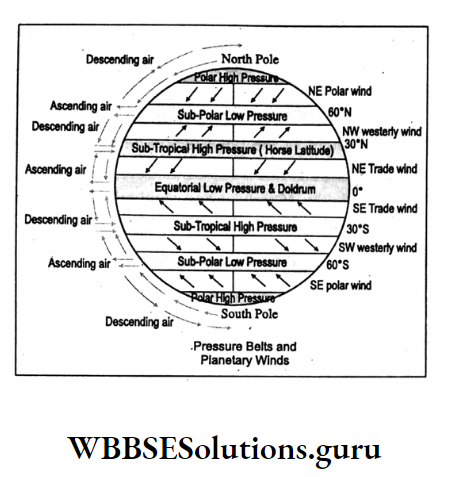
Monsoon Winds:
Being attracted by the low-pressure cell of the Rajasthan desert, the South-west monsoon wind gives rain in summer, while winter remains dry due to the dry and cold North-east monsoon wind.
Actually, the monsoon wind divides the Indian climate into four seasons.
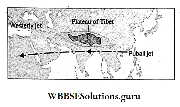
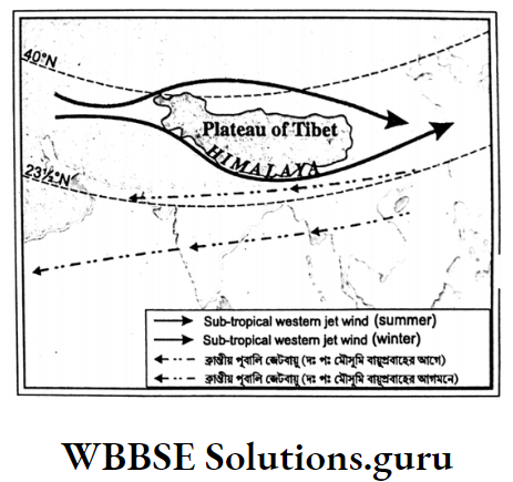
Jet Stream:
In India, Sub-tropical Westerly Jet blows in winter and Tropical Easterly Jet blow in the rainy season.
In winter with the advancement of the Westerly Jet southwards intensity of winter increases while with the shifting of the Easterly Jet, a northwards dry spell occurs resulting in drought.
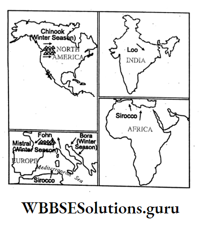
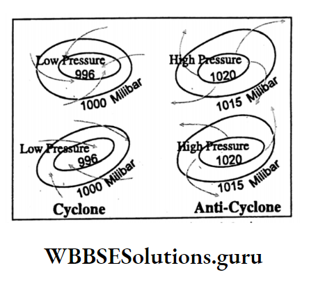
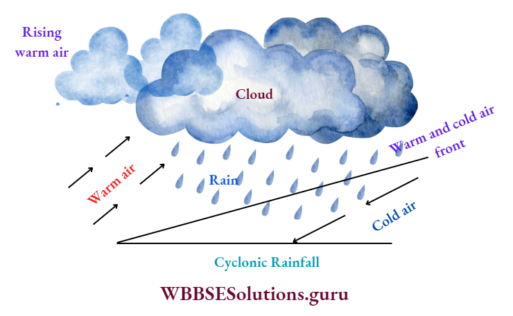
Tropical Cyclone And Western Disturbance:
In Autumn, the conflict between the retreating Southwest monsoon wind and the advancing North-east monsoon (Trde) wind causes Tropical cyclones which give cyclonic rains in coastal areas.
In winter, Western Disturbances originating in the Mediterranean Sea also give cyclonic rain in North-west India and snowfall in the Himalayan region.
EL Nino and La-Nina:
Usually, cold Peru or Humboldt ocean current flows northward along the Peru-Equador coast in the Pacific Ocean. In some years, in December-January warm south-flowing current replaces the cold current.
This is known as El Nino. It is found that the arrival of South-west monsoon wind in South Asia including India is delayed in the years of the appearance of El Nino. It causes drought and forest fires in those countries.
In some years with the departure of El Nino intense High pressure and stable weather prevails along the Peru coast while along the west coast of the Pacific Ocean, intense low pressure and heavy rainfall occur.
This is known as La Nina. In the years of La Nina rainfall in India increases. It causes floods, landslides and foggy winters.
Class 10 Geography Chapter 5 WBBSE Solutions
WBBSE Chapter 5 India Monsoon Winds And Seasons In India
Based on the arrival and departure of monsoon winds, rainfall, temperature and air pressure the Meteorological Department of the Government of India has divided the climate of India into four seasons which rotate in a cycle as follows:
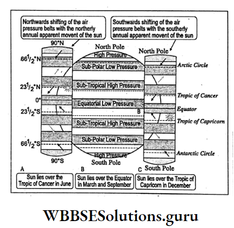
Summer (March to May)
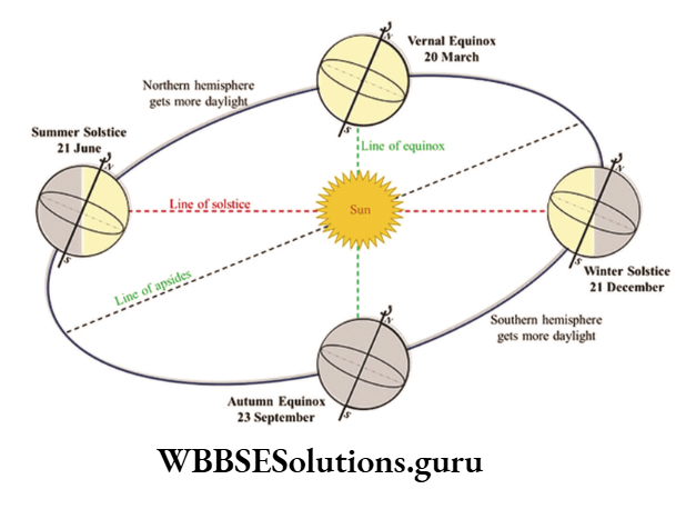
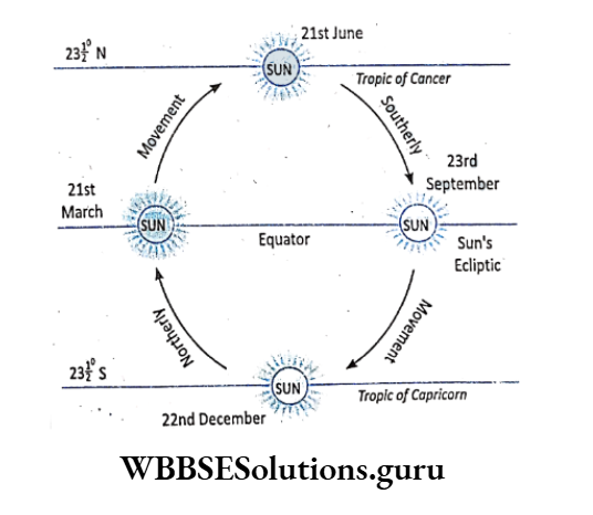
On the 21st of March, the sun lies over the equator. Gradually, it advances northward and accordingly temperature increases in India.
Temperature:
in the month of May, the temperature rises to 40°C in Madhya Pradesh and Gujarat. In the Rajasthan desert, it is nearly 48°C. By this time hot and dry wind called Loo sweeps over the Indo-Ganga plain. In Rajasthan, this is known as Andhi.
Rainfall:
In Summer, thundershower occurs which are locally known as Kalbasakhi in West Bengal, Mango Shower in South India and Bardichhila in Assam.
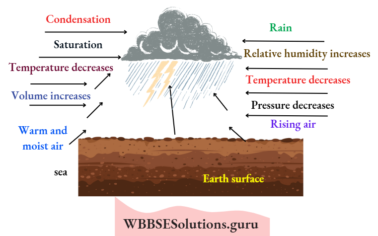
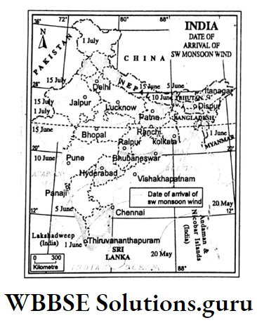
The rainy season (June to September)
On the 21st of June, the sun lies over the Tropic of Cancer. Therefore, an intense low-pressure cell develops in Rajasthan.
It pulls the South-east trade wind which on crossing the equator becomes South-west monsoon wind (according to Ferrel’s law) and arrives all of a sudden on the Cape of Comorin.
This is known as the ‘Burst of Monsoon’. It is then divided into two branches.
MAP
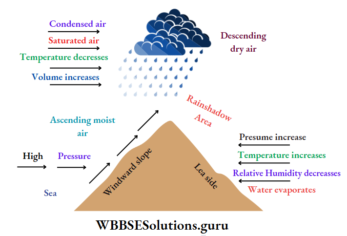
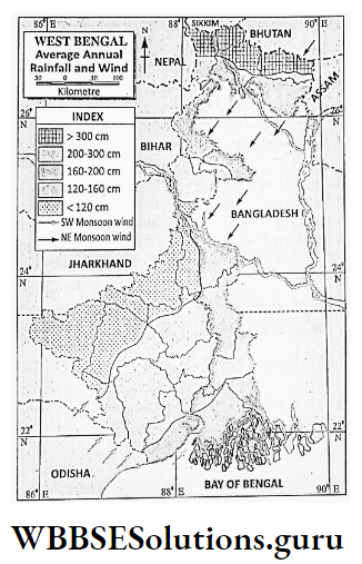
Arabian Sea Branch
It gives heavy orographic rain to the western coastal plains of India. But the Deccan plateau remains dry as it is located in the rainshadow areas of Western Ghats.
The northern section of the Arabian Sea branch does not give any rain in Gujarat as it blows parallel to the Aravalli range.
Class 10 WBBSE Geography Chapter 5 Explanation
Bay Of Bengal Branch
It gives heavy orographic rain to the southern slopes of the Himalayas and the Meghalaya plateau. Mausynram near Cherrapunji receives the highest rainfall (about 1250 cm) in the world.
But Shillong lies in the rainshadow area of the Meghalaya plateau. It gives rain in Assam, West Bengal and moves westward. As a result, rainfall decreases, gradually, in Bihar, Uttar Pradesh and Punjab.
Temperature:
The sky remains overcast. So, temperature varies between 20°C and 30°C.
Rainfall:
80% of rainfall in India occurs in the Rainy season. Rainfall is mostly orographic in nature. Maximum rainfall occurs in the Western coastal plains and in the Worth-eastern hills.
Except for the desert of the North-west, the rest of India receives rainfall varying between 60-200 cm.
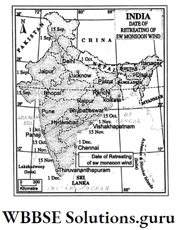
Retreating Monsoon or Autumn (October and November)
On the 23rd of September, the sun lies over the equator and moves to the south. So, the temperature starts to decrease in India and the Low-pressure cell disappears.
Consequently, the South-west monsoon wind retreats from India with the advancement of the North-east monsoon wind. These two winds conflict with each other and create cyclones.
Temperature And Rainfall:
Temperature is moderate. The sky remains clear. But cyclones hit the coasts of West Bengal (locally called Aswiner Jhar), Odisha and Andhra Pradesh.
Winter (December to February)
On the 22nd of December the sun lies over the Tropic of Capricorn and the temperature in North India becomes very low forming high pressure. The wind, therefore, blows from the northeast as offshore wind.
Temperature:
The average temperature of winter in North India varies between 10°C and 15°C, while in South 15 Sep. India it rises to 25°C.
Rainfall:
The North-east monsoon wind is very dry. So it does not give any rainfall in India but causes snowfall in the Himalayas.
Western Disturbances of 12 cyclonic origins disrupt the stable weather condition in North India.
Tamil Nadu coast receives winter rain from the North-east trade wind which on crossing the Bay of Bengal Kilometre becomes moist.
WBBSE Chapter 5 India Impact Of Monsoon Rainfall On Soil Natural Vegetation Agriculture
The impact of the Monsoon wind in India is immense.
Impact On Soil
The distribution of rainfall in India is uneven. Consequently, the soils of India also vary, accordingly.
Laterite soil is found in Meghalaya and Chota Nagpur plateau, Western slopes of the Western Ghat where due to excessive rainfall basic elements are leached underground while oxides of iron and aluminium are left on the topsoil.
Class 10 Geography Chapter 5 WBBSE Solutions
Desert or Sirozem soil is found in the Rajasthan desert, northern parts of Kachchh and Kathiwar where due to scarcity of rainwater (20-40 cm) minerals are accumulated on the top layers of soil.
Impact On Natural Vegetation
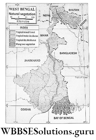
Excessive rainfall over the western and Eastern Himalayas has supported the growth of Evergreen trees.
Deciduous trees grow over most parts of India as India receives rain mostly in the rainy season and the trees shed their leaves in winter.
Impact On Agriculture
Agriculture in India mostly depends on monsoon rainfall. Paddy, sugarcane, cotton, tea, and jute are cultivated in the rainy season when the South-west monsoon wind gives rain.
But South-west monsoon wind is irregular and uncertain. Some years it arrives early, some years late. Sometimes rainfall occurs continuously for a few days.
Sometimes, it is rainless for a long time. As a result, floods and droughts are common. India. Ultimately, livelihood including agriculture is disrupted.
Concept Mapping
WBBSE Chapter 5 India Soils In India
Types Of Soils:
Based on variations in relief, rock type, climate and natural vegetation India may be divided into six soil types
- Alluvial soil,
- Black soil,
- Red soil,
- Laterite soil,
- Desert soil and
- Mountain soil.
Alluvial Soil
These are the principal soils of India. Alluvial soils are of three types
- Riverine soil,
- Coastal soil and
- Peat or Organic soil.
1. Riverine Soil :
Composition:
Riverine alluvial soil is composed of sand, silt and clay.
Characteristics:
This type of soil is formed by the deposition of silt, sand and clay in the river valleys. These are two types
- New alluvium or Khadar is deposited on the flood plains and near the river banks. It is fertile. It is fine-textured and acidic.
- The soil is grey in colour. It contains less amount of lime, humus and phosphorus.
- Old alluvium or Bhangar is found in old flood plains located away from the river. It is calcareous and coarse-grained. Its water-retaining capacity is low and its colour is dark.
Crop Association:
Alluvial soils favour the cultivation of rice, jute, wheat, cotton, oilseeds, sugarcane, jute, millets, pulses, tobacco and vegetables.
Regional Distribution:
River valleys of the Ganga, Indus and Brahmaputra.
2.Coastal Alluvial Soil:
Composition:
This type of soil is rich in oceanic silt, sand and salt.
Characteristics:
Coastal alluvial soil is light grey in colour. It is coarse-grained. The soil is rich in sodium, calcium, and magnesium. It is moderately fertile.
Crop Association:
Paddy, coconut, areca nut, and green chilly grow well.
Regional Distribution:
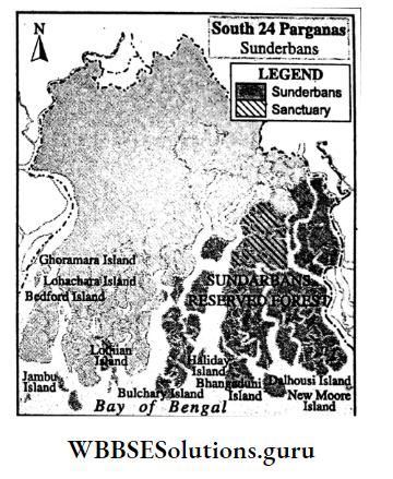
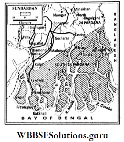
Coastal soil is found in the East and West coastal plains of India, especially in Sundarban in West Bengal where mangrove vegetation grows well.
3. Peat Or Organic Soil:
Composition:
This type of soil is composed of silt, sand, and clay mixed with organic matter.
Characteristics:
Dark grey colour. The soil is coarse-grained and porous. It is rich in silica.
Regional Distribution:
It is found in Kerala and Terai in Uttar Pradesh.
Class 10 Geography And Environment Notes WBBSE
Black Soil
This is the second most important soil in India.
Composition:
It is composed of clay (Kaolinite) and silt. Sand is less in amount.
Characteristics:
It is produced from lava rock basalt. Its colour is black. It is fine textured. The soil is rich in calcium carbonate, magnesium carbonate, iron, aluminium etc.
Its water-retaining capacity is high. It is popularly known as ‘Regur’. It favours cotton cultivation and hence, it is known as ‘black-cotton soil’. It is fertile.
Crop Association:
Cotton, rice, onion, oilseeds, oranges, grapes and vegetables are well-grown.
Regional Distribution:
Black soil is found in the Deccan Trap, especially Maharastra, the Southern part of Gujarat, Madhya Pradesh, Northern part of Karnataka. Telangana and the Northern part of Tamil Nadu.

Red Soil
This is the third important soil of India.
Composition:
Red soil is rich in sand and clay particles like Kaolinite.
Characteristics:
It originated from disintegrated ancient igneous and metamorphic rocks like granite, and gneiss. Its colour is red as it is rich in iron.
Its water retaining capacity is poor. The soil is rich in Potassium and phosphate. It is coarse-grained as the soil is sandy.
Crop Association:
Millets, especially, ragi, rice, tobacco, groundnut, potato and vegetables grow well in red soil.
Regional Distribution:
Red soil is found in Tamil Nadu, Karnataka, Andhra Pradesh, and Odisha in Deccan Plateau; Jharkhand in the Chota Nagpur Plateau; North-eastern mountainous region and in Meghalaya Plateau.
Laterite Soil
This is the fourth important soil of India.
Composition:
Laterite is rich in iron and aluminium oxides and contains less amount of organic matter and silica.
Characteristics:
The soil is red in colour due to the presence of iron. The word ‘Laterite’ is derived from the Latin word ‘Later’ meaning ‘bricks’.
These rocks are washed out through the leaching process by rainwater leaving a high proportion of iron and aluminium as residue.
They are course grained and acidic in nature. They are poor in plant nutrients and cannot retain moisture. So they are infertile.
Crop Association:
Rubber, tea, coffee, corn, cashew nut and rice grow in laterite soil only with the application of irrigation.
Regional Distribution:
Laterite soil is found in Western Ghats, Nilgiri, Cardamom and Eastern Ghats, the hilly region of Odisha, Jharkhand in the Chota Nagpur plateau and in Meghalaya plateau.

Desert Soil
Composition:
The soil is sandy. Due to the absence of vegetation, the soil is devoid of organic matter.
Characterístics:
It is grey in colour. The soil is rich in minerals like quartz, feldspar, hornblende, phosphate etc. but poor in nitrogen. Desert soil is known as size.
Crop Association:
With help of irrigation through the Rajasthan Canal crops like cotton, jowar, sugarcane, oilseeds, and wheat are grown abundantly.
Class 10 Geography And Environment Notes WBBSE
Regional Distribution:
Desert soil is found in the Rajasthan desert and in the northern part of Kathiwar and Kachchh of Gujarat.
Mountain Soil
Composition:
It is rich in stones, clay and humus.
Characteristics:
Due to the slope of the land the soil is shallow. Its colour is greyish brown. The soil is poor in potash, phosphorus and lime but rich in nitrogen and organic matter. The soil is fine-grained.
Its water retaining capacity is medium. On the upper part of the mountain, the soil is acidic podzol type and in the lower part, brown chestnut soil is found.
Crop Association:
Rubber, tea, coffee, spices, and fruits grow well in this soil.
Regional Distribution:
The soil is found in the West and East Himalayas, Western Ghats, Eastern Ghats and Cardamom hills.
WBBSE Chapter 5 India Soil Erosion
Soil is the most valuable resource, yet its depth is only 10-20 cm. This loose layer of soil is easily removed by rain and wind if it is not held by plant roots.
Usually, the rate of removal of soil is faster than that of its formation. Soil erosion is its removal by natural or man-made processes. More than half of the Indian landmass is damaged by soil erosion.

Causes Of Soil Erosion
Soil erosion is caused by two ways
- Natural and
- Human activities.
Natural Causes
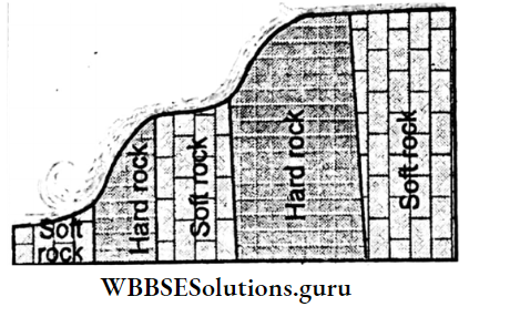
Surface Runoff :
Rainwater washes the top layer of the soil. This is known as Sheet erosion. Gradually, Surface water runs in distinct paths and causes soil erosion.
This is known as Rill erosion. When rills are widened into gullies soil erosion increases further, this is known as Gully erosion.
Wind:
In deserts and seas sides strong wind causes soil erosion.
Nature Of Rainfall:
The amount of rainfall, especially the amount of rainfall per hour i.e. intensity of rainfall as well as sizes of raindrops are responsible for soil erosion.
Topography :
The greater the slope of the land higher is the amount of soil erosion. According to pedologist, H. H. Bennet, soil erosion increases by 25% with only a 1% increase in the slope of the land.
This is why soil erosion occurs more on the plateaus and the mountains than on the plains.
Landslide:
The landslide caused by heavy showers or earth movement is responsible for a huge amount of soil erosion.
Human Activities
Pressure Of Excessive Population:
The rapid increase in population is responsible for the increase in habitat land, and the establishment of factories which in turn, are responsible for the looseness of the soil and ultimately rainwater and wind wash away the loose soil particles.
Overgrazing :
Overgrazing causes the removal of plant and grass cover over land and the top soils are loosened as a result, soil erosion takes place easily.
Unscientific Mining:
Due to industrialisation increasing demand for minerals causes unscientific mining which may lead to soil erosion.
Deforestation :
Plant roots hold soil particles, Plant leaves protect soil from the strike of raindrops and the canopy protects soil from the heat by giving shade also wind velocity is reduced by the presence of forests. So deformation due to unscientific felling of trees may lead to excessive loss of soil particles.
Conventional Method Of Farming:
The conventional process of farming by which farmland becomes open when ploughing and by shifting cultivation which is locally known as jhum cultivation. In the states of North-eastern India when land is kept open for 3-4 years, topsoil is removed quickly.
Regions Of Soil Erosion
Soil erosion is increasing in India at an alarming rate, especially in the Himalayan mountainous region. North-eastern hills, a central part of Rajasthan.
Chambal- Betwa river basin in Uttar Pradesh and Madhya Pradesh, Namarda and Tapi river basin in Gujarat, Plateaus of Jharkhand and West Bengal and in the western part of Maharastra.
WBBSE Chapter 5 India Consequences Of Soil Erosion
Soil erosion affects not only the economic and cultural activities of man but also adversely affect our environment. This can be realised from the following facts:
Loss Of Top Layer Of Fertile Soil:
The top layer of soil is rich in organic and mineral contents and its removal turns the soil infertile causing low agricultural produce.
Fall of groundwater table and reduction in soil moisture:
Soil erosion causes the removal of the top layer of soil exposing bare hard rocks on which when river flows cannot penetrate.
As a result, the groundwater table is lowered due to a lack of supply of water. Consequently, moisture in the soil is also lost.
Expansion Of Deserts:
In deserts, wind removes soil from distant places. As a result, the process of desertification is intensified. This soil erosion leads to the expansion of deserts.
Frequency Occurrence Of Flood And Drought:
Due to siltation, the river becomes shallow. So, little rain causes floods. Erosion of topsoil lowers the humidity of the soil. Ultimately, the soil becomes dry and leads to drought.
Increasing Siltation In Canals And Rivers:
Soil is removed by rivers and wind and is deposited in canals, rivers and other water bodies. As a result, canals and rivers are filled up by silts and eventually, these canals and rivers dry up.
Increasing Landslide:
In the mountainous region, soil erosion takes place along the direction of the sloping land becomes open and causes landslides.
Hindrance In Economic Prosperity And Cultural Development:
Soil erosion reduces soil fertility and ultimately, lowers agricultural production. Consequently, agro-based people as well as agro-based industries are in crisis.
Again, siltation reduces the navigability of rivers. So, the waterway through the river was disrupted. River floods also destroy life and wealth.
WBBSE Chapter 5 India Prevention Of Soil Erosion And Soil Conservation
Soil conservation is to protect soil from soil erosion i.e. Soil conservation includes the methods of prevention of soil erosion.
Methods Of Prevention Of Soil Erosion
Tree Planting :
The plantation of trees is essential to protect the land from soil erosion by covering grasses and plants.
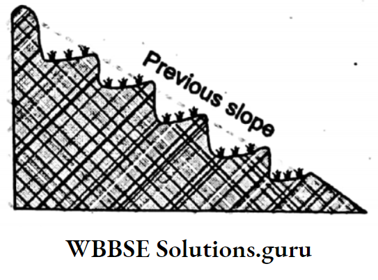
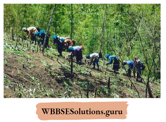
Terrace Farming:
Steep slopes foster soil erosion. So steep slopes are terraced and cultivation is practised on terraces or steps to reduce the rate of soil erosion.
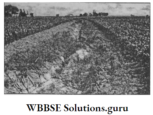
Contour Ploughing:
Ploughing along the contours i.e.” transverse to slopes, soil erosion is reduced.

Strip cropping:
On treeless sloping land strips of farmlands are made on which cultivation of pulses, leguminous crops, and groundnut is practised to reduce soil erosion as well as to retain moisture in the soil.
Gully Ploughing:
Gullies or bad land topography is protected from soil erosion by planting trees beside the gullies. Leguminous crops and pulses are also cultivated along the gullies to reduce soil erosion.
Prevention of Jhum cultivation:
Jhum cultivation is practised in the states of Northeastern hills by tribal people.
Through this process, a piece of land is cleared by burning trees and cultivated for 3-4 years after which they shift to another place and cultivate in a similar way.
This method of cultivation is known as the ‘slash and burn’ method or shifting cultivation. As a result, the forest is destroyed and soil erosion takes place rapidly. So it is indispensable to stop Jhum Cultivation to prevent soil erosion.
Concept Mapping

WBBSE Chapter 5 India Natural Vegetation
Naturally growing trees, plants, and grasses are together called Natural Vegetation.
Types Of Natural Vegetation
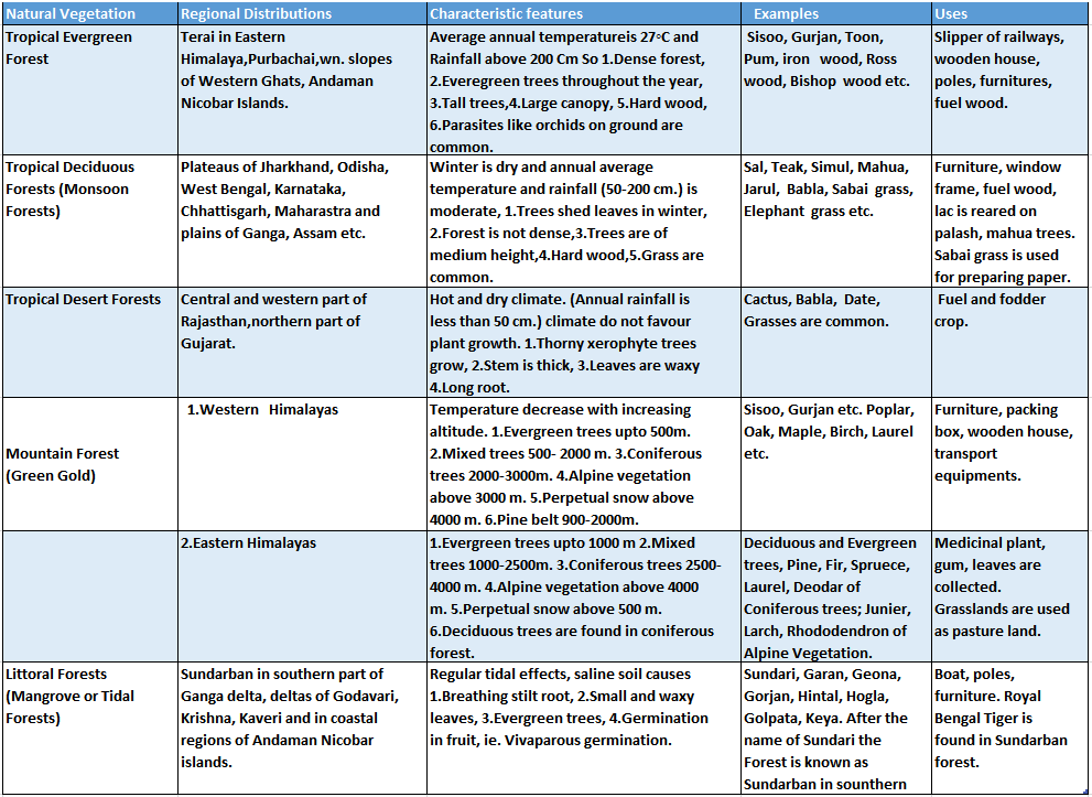
Based on rainfall, temperature together with soil in India there are five types of Natural Vegetation which are described in a tabular form below:

WBBSE Chapter 5 India Need For Conservation Of Forests
At present, in India, only 19-27% of the Geographical area is under forests. But according to the scientist, the said percentage should be 33 (one-third of the country).
Otherwise, the sustainability of the environment will be in danger. So Forest conservation is indispensable in India.
So that, forest produce will not be disrupted. The wise and scientific method of felling trees is known as Forests conservation.
Measures Of Forest Conservation
The following measures are necessary for the conservation of forests:
Reduction of felling of premature trees:
The feeling of immature trees should be controlled. Only mature trees should be cut.
Prohibition of indiscriminate deforestation:
Unwise felling of trees causes deforestation. So indiscriminate felling of trees should be checked.
Use of alternate source of energy instead of fuel wood:
Cheap and alternate methods of fuel should be used to control the loss of forest wood.
Prevention of forest fire:
Dry leaves and branches should be cleared to control the spread of forest fires.
Control of diseases of forest trees chemically and biologically:
Insecticides and pesticides should be spread to control plant diseases.
Controlled grazing of cattle:
Overgrazing causes the depletion of nursery plants and grassland. So afforestation is delayed.
Afforestation and reforestation:
Instead of felling trees in barren and fallow land trees should be planted and replanted there to check deforestation.
Adaptation of forest management like the felling of mature trees and selective tree felling operations:
For development activities only selected and mature trees from pure stands should be felled. For this purpose, forest management programmes should be undertaken.
People’s participation:
Forest is a natural gift and wealth to men. There is no alternative. So, the active involvement of man is indispensable for the conservation of forests.
Class 10 Geography And Environment Notes WBBSE
WBBSE Chapter 5 India Social Forestry And Agro-Forestry
Social Forestry
Social forestry is afforestation outside the forest area in barren and fallow land for the benefit of the economically weaker section of our society.
In this programme, trees are planted beside the canals and rivers, in open spaces of schools, offices and religious places, and along the road and railways.
As a result, the production of wood, fruits, fodder crops and forest products increases as well as unused barren and fallow lands.
Are used for economically profitable purposes leading to the development of the environment as well as a socio-economic field.
Agro-Forestry
Along with cultivations, farmers also plants trees in their fields, pond boundary, open spaces in and around houses, and barren or fallow lands.
This is known as agro-forestry. As a result, farmers can produce agricultural crops as well as wood and forest products commercially thereby increasing their income.
Consequently, the sustainability of the environment is also maintained.
WBBSE Chapter 5 India Economic Environment
Agriculture In India :
Most of the Indian people are agrarian. About half of the total working population of India depends on agriculture. (6% of Japanese and 3% of Americans are agrarian).
Major Characteristics Of Indian Agriculture
Indian agriculture is characterised by the following features:
Subsistance Agriculture:
As India is overpopulated, most of the agricultural produce is used by the Indians and the surplus is insignificant.
This type of agriculture is known as subsistence agriculture and is the main feature of Indian agriculture.
Population Pressure:
The rapid growth of the population is responsible for population pressure on agriculture. So Indian agriculture is labour-intensive.
Predominance Of Population Force:
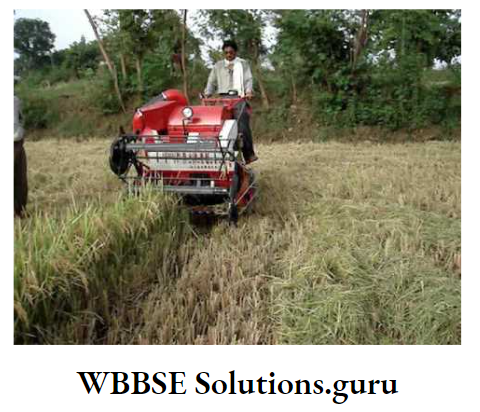
In Indian agriculture instead of using modern machinery like a tractor, harvester traditional methods of cultivation using animate energy is still in practice.
Dependence On Monsoon Rain:
In most parts of India single cropping is practised using monsoon rain on a seasonal basis.
Use Of Irrigation Water:
In some places with the help of irrigation water multiple cropping (two/three crops) is also practised in India.
Small Size Of Land Holding:
In a labour-intensive subsistence agriculture population pressure is responsible for divided and subdivided holdings added by hereditary inheritance.
As a result, Indian agriculture is characterised by small holdings.
Uncontrolled Uses Of Pesticides And Chemical Fertilizers:
Unwise and unscientific use of insecticides, pesticides and chemical fertilizers leads to the deterioration of the ecosystem including soil and water pollution.
Predominance Of Food Crops:
About 66% of cultivated land is devoted to the production of rice and wheat.
Insignificant Place For Fodder Crops:
Though Indian agriculture depends on animate energy; the cultivation of fodder crops is insignificant so India is scarce in fodder crops.
Variety Of Food Crops:
Multiple cropping is practised here as there is no scope for an Extensive method of farming.
A variety of crops are produced here, such as food crops like rice, wheat, jawar, bajra, ragi, and corn; oilseeds like mustard, groundnut, sunflower etc.
Pulses like a mug, muser, matar, arhar, buli; fibre crops like cotton, jute, mesta and commercial crops like tea, coffee, rubber, sugarcane etc.
WBBSE Chapter 5 India Economic Environment Classification Of Crops On The Basis Of Uses
There are four types of crops produced in India on the basis of their uses:
Food Crops:
Crops which give nutrients in the diet are known as food crops these are two types
- Cereals like rice, wheat, oat, jowar, bajra etc. and
- Pulses like, mug, muser, cola etc.
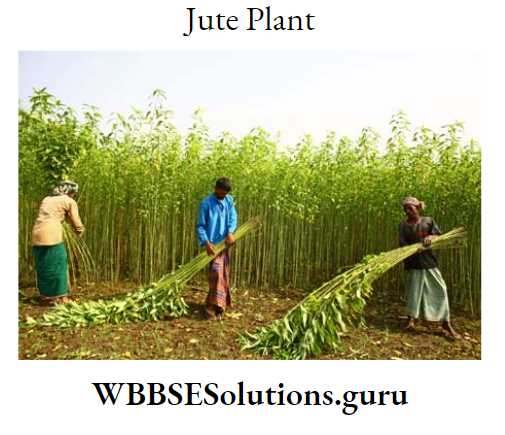
Fibre Crops:
Crops from which yearn is produced are known as a fibre crop, such as cotton, jute, hemp, mesta etc.
Plantation Crops:
Crops produced in large farms for export are known as Plantation crops such as tea, coffee, rubber etc.
Other Crops:
Other crops produced in India are sugarcane, potato and a variety of fruits, vegetables and oilseeds.
WBBSE Chapter 5 India Economic Environment Classification Of Crops On The Basis Of Seasons
According to seasons crops produced in India are of three types:
Kharif Crops
Crops cultivated at the beginning of the rainy season and harvested at the end of autumn are known as Kharif crops, such as aman rice, cotton, sugarcane, jowar, bajra, ragi, corn, groundnut etc.
Rabi Crops
Crops cultivated at the beginning of winter and harvested at the beginning of summer are known as Rabi crops, such as wheat, oat, potato, mustard, pulses etc.
Zaid Crop
Crops cultivated in spring (March) and harvested at the beginning of the rainy season (June) are known as zaid crops, such as watermelon, cucumber, spinach and vegetables.
Major Crops Of India
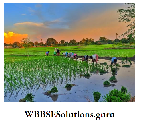
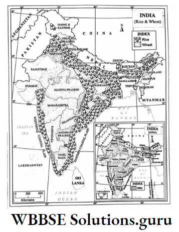
Rice: Principal food crop of India
Rice is the principal food crop of India accounting for 25% of the cultivated land of the country.
Favourable Geographical Conditions For Rice Production:
Physical Environment
Climate:
A hot and humid climate is ideal for rice cultivation
- Temperature: Rice cultivation requires 20° to 30°C temperature.
- Rainfall: 100 to 200 cms rainfall is ideal for rice cultivation.
- Soils: Fertile loamy soils especially, riverine alluvial soil ideal for rice cultivation.
- Relief: Level land is ideal because stagnant water is essential for rice cultivation.
Economic Environment
- Labour: plenty of cheap and skilled labours are required for the ploughing of soil, transplantation of seeds, weeding, harvesting, threshing etc.
- The facility of modern methods of cultivation: Production of rice increases if machinery, H.Y.V. seeds, fertilizer, insecticides, irrigation water etc. are used in the cultivation of rice.
- Capital: Large investment is required for the application of modern methods.
- Market: The demand for rice increases the production of rice.
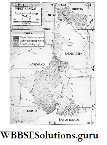
Distribution
Nearly all the states and union territories of India produce rice, such as
- West Bengal ranks 1st position (16%) in rice production in India. Leading rice-producing districts are North and South 24 Parganas, Purba and Paschim Medinipur, Jalpaiguri, Barddhaman, Bankura, Birbhum, Uttar and Dakshin Dinajpur.
- Ganga Plain of Uttar Pradesh (ranks 2nd position) Godavari and Krishna Delta of Andhra Pradesh (ranks 3rd position), Sutlej Plain of Punjab, Kaveri Delta of
- Tamil Nadu, Mahanadi valley and delta of Odisha, and Brahmaputra valley of Assam also produce plenty of rice.
Production:
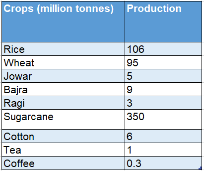
India ranks 2nd position in rice production in the world next to China. In the year 2013-14, India produced about 106 million tonnes of rice.
Trade:
Every year India exports fine-quality rice (Basmati and Dehradun rice) to France, Australia, the U.K., and Germany.
Wheat: Second Important Food Crop
Favourable Geographical Conditions For Wheat Production:

Physical Environment
- Climate: Dry and cold weather is ideal for wheat cultivation.
- Temperature: Wheat cultivation requires 15°-20°C. But during ripening time it should be 25°C.
- Rainfall: 50 cm to 100 cm rainfall is ideal for wheat cultivation.
- Soils: Fertile heavy Loam or silty soils are necessary for the cultivation of wheat.
- Relief: Undulating or slightly sloping land is ideal for wheat cultivation.
Economic Environment
- Labour: The cultivation of wheat is not labour-intensive like rice.
- Capital: Wheat cultivation requires huge investments as most of the farming operations are done by machines.
- Fertilizer: Chemical fertilizer like nitrogen, potash, and phosphate is applied.
- Others: Modern method of farming requires H.Y.V. seeds, insecticides, and agricultural implements.
Distribution
States of North India have suitable climatic conditions for the cultivation of wheat. Uttar Pradesh (ranks first)-Districts of Saharanpur, Etwa, Muzzafarnagar.
Punjab (ranks second position)-Districts of Ferozepur, Ludhiana, Patiala, Bhatinda, Gurudaspur, Madhya Pradesh (ranks third position)-Districts of Sagar, Bidisha, Raisen.
Hisar, Ambala, Rohtak, and Gurgaon (Gurugram) of Haryana produce plenty of wheat. Other States include Bihar, Rajasthan, Gujarat and West Bengal.
Production:
India ranks 2nd position in the production of wheat in the world. In the year 2013-14, India produced about 95 million tonnes of wheat.
Trade :
Some amount of wheat is exported to the neighbouring countries namely, Bangladesh, Nepal, and Bhutan.
Millet: Jowar, bajra, and ragi are together, known as Millet which grows in India.
Favourable Geographical Conditions For Cultivation Of Millet:
Millets are hard varieties of crops. Usually, millets grow in poor land where irrigation is not possible.
Class 10 Geography Chapter 5 WBBSE Solutions
Physical Environment
- Climate: Millets grow in the rainy season as a Kharif crop, but need not require much water.
- Temperature and Rainfall: 25-30°C temperature and 30-70 cm rainfall favour the cultivation of millet.
- Soils: Infertile red soil and dry alluvial soil are used for the cultivation of millet.
- Relief: Millets grow in plain as well as undulating land.

Economic Environment
- Labour: Skilled labours are required for sowing, harvesting etc.
- HYV Secds: HYV seeds are required to increase production.
Distribution
Bajra is the most important millet followed by jowar. Jowar grows well in Maharastra, Andhra Pradesh, Madhya Pradesh, Gujarat, and Rajasthan.
Bajra grows in Rajasthan, Haryana, Gujarat, Maharastra, Andhra Pradesh and Tamil Nadu. Ragi grows well in Karnataka, Tamil Nadu and Andhra Pradesh.
Maharastra ranks first position in jowar production, Rajasthan ranks first position in bajra production and Karnataka ranks first position in Ragi production.
Production Of Major Crops: 2013-14
Source: Economic Survey: 2014-2015 (Govt. of India)
Sugarcane: Cash crop. Sugar, Molasses alcohol are produced from sugarcane.
WBBSE Chapter 5 India Economic Environment Favourable Geographical Environment
Physical Environment
- Climate: Sugarcane grows in the Torrid zone.
- Temperature and Rainfall: 20°-26°C temperature and 150 cm rainfall are required for sugarcane cultivation.
- Sea breeze: Salty wind favours sugarcane cultivation.
- Soils: Fertile loamy soil mixed with lime and salt are favourable for sugarcane cultivation.
- Relief: Well-drained sloping land is favourable for cotton cultivation.
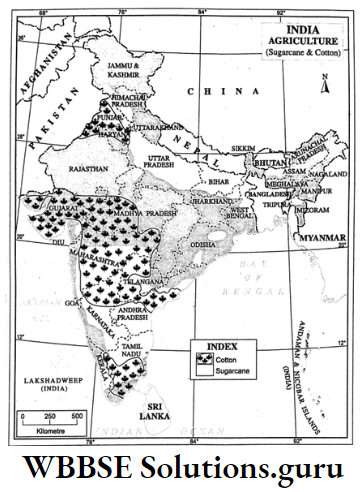
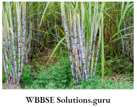
Economic Environment
- Labour: Abundant skills are required for clearing land, sowing seeds, harvesting crops etc.
- Modern transport system: Well-knit quick transport is required for taking sugarcane from the field to the factory within 24 hours to extract sugar.
- Others: Regular application of fertilizer, and irrigation are also important factors for the cultivation of sugarcane.
Distribution
Uttar Pradesh (ranks first position)-Saharanpur, Faizabad, Bulandshahar, Ajamgarh, Balia, Baranasi. Maharastra (ranks second in production)-Kolhapur, Sholapur, Satara, Pune; Karnataka (Ranks third in production)-Shimoga, Belgaum produce sugarcane.
Champaran, Darbhanga of Bihar; Godavari and Krishna delta of Andhra Pradesh; Amritsar and Jalandhar of Punjab; Ganganagar of Rajasthan; Hisar and Rohtak of Haryana.
Barddhaman, Birbhum, Nadia and Murshidabad of West Bengal are also famous for sugarcane cultivation.
Production:
About 350 million tonnes of sugarcane was produced in India in the year 2013-14.
Trade:
The juice of sugarcane is extracted within 24 hours of its harvesting. So import-export is carried out for sugar.
Cotton: Principal fibre crop of India. 70% of cotton produced in India is used in the production of clothes.
WBBSE Chapter 5 India Economic Environment Favourable Geographical Conditions For Cotton Cultivation
Physical Environment
- Climate: Cotton grows best in Tropical and Subtropical climates.
- Temperature and Rainfall: 20°-25°C temperature and 60-100 cm rainfall are ideal for cotton cultivation.
- Sea Breeze: Salty wind favours cotton cultivation.
- Frost-free days: During its growth, at least 200 frost-free days are required.
- Soil: Fertile loamy soil mixed with lime, especially black lava soil of the Deccan plateau favours cotton cultivation.
- Relief: Well-drained plain land is suitable for cotton cultivation.

Economic Environment
- Labour: Sufficient and cheap labours are required for planting, collecting cotton balls etc.
- Irrigation: In dry weather, cotton plants are less attacked by insects. So in dry regions, with the help of irrigation cultivation of cotton is better.
- Insecticides: Cotton balls are often attacked by White flies, Ball weevils.
- Others: HYV seeds and fertilizer are also essential for better production of cotton.
Distribution
Gujarat (Ranks first in production)-Ahmedabad, Varuch, Vadodara, Surendranagar, Surat; Maharastra (Ranks second in production)-Sholapur, Nasik, Nagpur, Wardha.
Andhra Pradesh (including Telangana)-Guntur, Kurnool, and Anantapur produce cotton abundantly.
Ferozpur, Ludhiana, Jalandhar of Punjab, Ambala, Hisar of Haryana; Ganganagar of Rajasthan; Coimbatore, Madurai of Tamil Nadu, Belgaum, Dharwar of Karnataka, Ujjaini of Madhya Pradesh are also famous for cotton cultivation.
Production:
In the year 2013-14, about 6 million tonnes of sugarcane were produced in India.
Trade:
India holds the second position in the production and export of cotton in the world. India exports cotton to Japan, Germany and other countries.
Tea: Tea is a cheap beverage and is widely used as a mild stimulator.
Class 10 Geography Chapter 5 WBBSE Solutions
WBBSE Chapter 5 India Economic Environment Favourable Geographical Conditions For Tea Cultivation
Physical Environment
- Climate: Tea is cultivated, generally, on the mountain slopes of monsoon climate.
- Temperature: Tea plantation requires an average summer temperature of 27°C.
- Rainfall: It requires plenty of rainfall, about 150 to 250 cm. annually.
- Soil: Fertile loamy soils rich in iron are ideal for tea plantations.
- Relief: Tea plantation requires hill slopes so that water can be easily drained out.
Economic Environment
- Labour: Skilled labours are required for plucking leaves. Women and children are employed to pluck two leaves and a bud.
- Fertilizer: Tea plants require the good application of fertilizer to replenish soil fertility as it absorbs nutrients of the soil quickly.
- Others: Application of modern equipment, organic pesticides, capital, advanced management system and domestic and international demand for tea are important factors in the plantation of tea.
Distribution
In India tea is cultivated in two areas
- North India,
- South India.
North India:
About 75% of tea produced in India comes from North India. Assam and West Bengal are two major producers of tea. Asam-The state holds 1st position in the production of tea in India.
Important tea-producing districts are Darang, Shibsagar, Lakhimpur and Kachhar. About 50% of the country’s production is contributed by Assam. West Bengal-The state ranks 2nd position in tea production in India.
About 22-23% of tea produced in India is contributed by West Bengal. Darjeeling district produces the best quality flavoured tea in the world.
Terai and Duars of Jalpaiguri and Koch Bihar districts also produce tea. Other states of North India-Hills of Tripura, Ranchi and Hazaribag of Jharkhand, Kangra valley of Himachal Pradesh, Dehradun and Garwal of Uttarakhand.
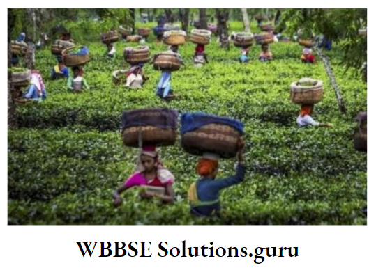
South India:
South India contributes about 20% of the country’s total production of tea. In south India, tea is produced on the hill slopes of Nilgiri, Cardamom, Palni, Anaimalai etc.
Important tea-producing centres are Coimbatore and Nilgiri in Tamil Nadu; Chikmagalur, Coorg and Hasan of Karnataka, and Quilon (Kollam) of Kerala. Tamil Nadu ranks 3rd position in the production of tea in India.
Production:
In the year 2013-14, India produced nearly 1 million tons of tea.
Trade:
About 1/3rd of world tea is produced in India. About 1/5th of Indian tea is exported to the U.K., Russia, Iran, and Pakistan. Most of the Indian tea is exported through Kolkata port.
Coffee: Coffee is prepared by frying and grinding the berriés of the coffee plant.
WBBSE Chapter 5 India Economic Environment Favourable Geographical Conditions For Coffee Plantation
Physical Environment
- Climate: Coffee grows well in equatorial climates as well as in hot and humid tropical climates.
- Temperature: coffee plant requires 20°-30°C temperature.
- Rainfall: Coffee plants need very high rainfall of 150-200 cm.
- Soil: coffee tree thrives best on red loamy

Economic Environment
- Labour: Plenty of workers are required for plantation, picking of berries, frying and grinding of berries.
- Others: Advance management including plantation, packaging and exporting are all important factors for coffee cultivation.
Distribution
Most Indian Coffee is produced in South India. Karnataka- the state ranks 1st position (70%) in coffee production in India. Important coffee-producing districts are Shimoga, Chikmagalur, Hasan, Mysore etc.
Kerala:
About 20-22% of coffee plantations are in Kerala which ranks 2nd position in coffee production in India. Important plantations are Palghat, Kottayam, Aleppi etc.
Tamil Nadu:
About 9% of the country’s coffee plantations are in Tamil Nadu which ranks 3rd position in coffee production in India.
Madurai, Salem, and Coimbatore are famous for coffee production. Other coffee-producing states are Maharastra, Tripura, Andaman-Nicobar Islands etc.
Production:
In the year 2013-14, India produced about 3 million tonnes of coffee. Trade-India exports coffee to the USA, France, Germany and Australia.

WBBSE Chapter 5 India Economic Environment Problems Of Indian Agriculture And Their Solutions
Problems:
Dependency on Monsoon rain-Indian agriculture mostly depends on the vagaries of monsoon rainfall. In most of the fields only one crop, single cropping is cultivated in the rainy season.
Solution:
With the application of irrigation, multiple cropping is now practised.
Problems:
The traditional method of cultivation-Yield rate is low as agriculture is mostly practised by traditional methods.
Solution:
The yield rate may be increased by the application of HYV seeds, fertilizer, and modern implements and by training farmers to cultivate using modern methods.
Problems:
Small holdings-Indian holdings are small, so it is not possible to use modern technology.
Solution:
Agriculture should be practised through a cooperative system by the consolidation of small holdings.
Problem:
Landless farmer-Most of Indian farmers do not have their own land.
Solution:
The government is now trying to make the tillers, owners of the lands by law of the Land Reform Ordinance.
Class 10 Geography And Environment Chapter 5 Solutions
Causes Of Agricultural Prosperity In Punjab Haryana-A Case Study
Punjab-Haryana, located in North-West India is the most important agriculturally rich area. This is the best wheat belt in India. Plenty of rice, cotton, and sugarcane are also produced here. Not only in India, but the region is also one of the highest producers of wheat, rice and sugarcane in the world. The causes of such tremendous development are:
Climate
The states of Punjab and Haryana are located in a Sub-tropical climate which is ideal for wheat cultivation. Western disturbance also gives winter rain which helps in the cultivation of wheat including other rabi crops.
Soil
The fertile alluvial soil of the plains of Punjab-Haryana favours the cultivation of wheat, rice, cotton, and sugarcane.
Irrigation
The irrigation facility has been extended to dry parts of this region. Well and tube well irrigation also helps in agriculture. Perennial canals of the Bhakra-Nangal multipurpose river valley project also irrigate wide areas of this region.
Impact Of the Green Revolution
In Indian agriculture, Green Revolution was initiated in Pubjab-Haryana during the late ’60s and early ’70s. Its impact was maximum on wheat cultivation and also on the cultivation of rice, cotton and sugarcane.
Consequently, there was a tremendous increase in the production of wheat, as well as rice, cotton and sugarcane.
Use Of Modern Technology:
Chemical fertilizers, insecticides and modern machinery like tractors, and harvesters are widely used.
Capital :
Most of the farmers of this region are financially rich.
WBBSE Chapter 5 India Economic Environment Industries In India
The Process by which raw material is changed into a useful secondary product is called Industry.
Though India is an agricultural country, industrial progress in India has placed her in a leading position among developing countries. Important industries in India are:
- The textile industry, namely cotton and jute,
- Iron and steel industry,
- Engineering industry,
- Petro-chemical industry,
- Automobile industry and
- Information technology.
Factors Affecting The Location Of Industries
Factors favourable to the location of an industry are :
1. Raw Material:
Raw material plays an important role in localising industries. Raw materials are of two types
- Impure raw material-raw materials which lose weight after production are known as impure raw materials, such as sugarcane, copper ore, iron ore etc. Industries using impure raw materials are, generally, located near the raw material-producing region.
- Pure raw material-There are some raw materials which do not lose their weight after production. These are known as pure raw materials, such as cotton, etc etc. Industries using pure raw materials may develop either near raw materials or far away in the market area.
2. Water:
Industries are, usually, set up near rivers, and lakes so as to get a supply of water for industrial activities as well as for the workers also.
3. Electricity:
A cheap and regular supply of electricity is essential for the uninterrupted production of industries. So, Industries prefer locations near the source or availability of electricity.
4. Transport:
Location of industry prefers a well-knit transport system to collect raw materials, marketing of finished goods and for movements of labours.
5. Labour:
The availability of cheap and skilled labours also controls the location of industries.
6. Market:
Market or demand for finished goods plays a vital role in setting up industries. Without the demand for products, the industry can not be set up.
7. Capital:
Monetary affluence is essential for the purchase of land, the establishment of factories, the collection of raw materials, the payment of wages of workers etc.
In addition, favourable climate and advanced technology also play important roles in localising industries.
Class 10 Geography And Environment Chapter 5 Solutions
WBBSE Chapter 5 India Economic Environment Classification Of Industries On The Basis Of Nature Of Raw Materials
Based on the nature of raw materials, industries are divided into four groups
- Agro-based industry,
- Animal-based industry,
- Forest-based industry and
- Mineral-based industry.
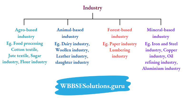
Causes Of Development Of Industries
Iron and Steel Industry :
The iron and steel industry plays an important role in the economic upliftment of a developing country like India. The principal raw materials of the iron and steel industry are coal, iron ore, limestone, and manganese.

WBBSE Chapter 5 India Causes Of Development Of Iron And Steel Industry In India
In India, large-scale integrated iron and steel factories are located in two areas:
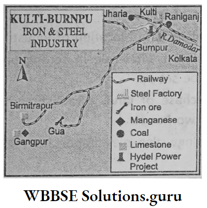
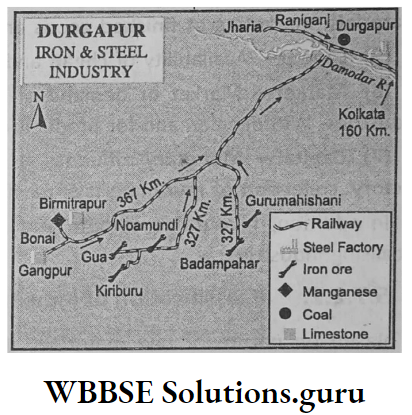

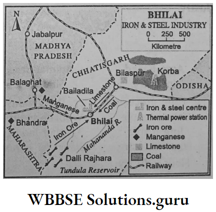

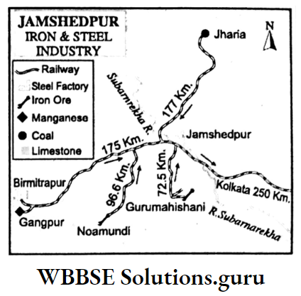
East-Central India
Important iron and steel centres are Kulti-Burnpur and Durgapur of West Bengal; Bokaro and Jamshedpur of Jharkhand; Bhilai of Chhattisgarh and Rourkela of Odisha. The causes of the development of these factories are :
Availability Of Raw Materials:
Coal is supplied from Raniganj, Jharia, Giridih, Karanpura, Bokaro, and Talcher; iron ore from Gua, Noamundi, Badampahar, Bonai, Dalli-Rajhara, Bailadila; limestone from Birmitrapur, Daltongunj, Bhabnathpur; dolomite and manganese from Sambalpur, Gangpur and Sundargarh.
Water:
Water is supplied from the rivers Damodar, Barakar, Subarnarekha and Kharkai.
Electricity:
Korba, Talcher, Bokaro, Patratu, and Mejia power stations supply electricity to these factories.
Transport Facility:
Eastern and south-eastern railways and National Highways help in transporting raw materials and finished goods.
Port:
Nearness to the ports Kolkata, Haldia and Paradwip provide import-export facilities.
South India
Iron and steel centres of this region are Visakhapatnam of Andhra Pradesh, Bijoynagar and Bhadrabati of Karnataka and Salem of Tamil Nadu. The following factors are responsible for the development of the iron and steel industry in this region.
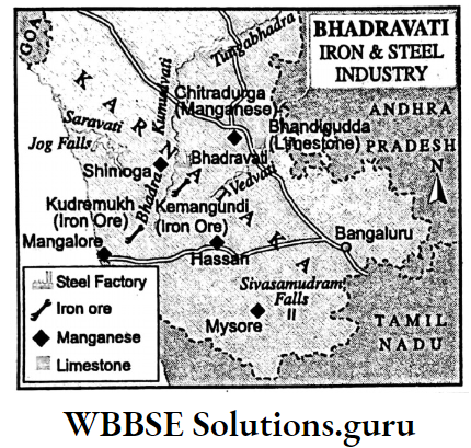


Raw Material:
Iron ore of Bellari-Hospet, Cudappa, Kurnool, Babubadan hills, Salem and Tiruchirapalli; coal of Singareni, Neively; manganese of Shimoga, Chitradurg; limestone and dolomite of Salem and Tiruchirapalli are used in these factories.
Water:
River Tungabhadra and Bhadra and Stanly reservoirs provide water.
Electricity:
Thermal power plants of Ramgundam and Neively and hydel plants of the Tungabhadra project and Sarabati project supply electricity.
Port:
Nearness to Visakhapattanam, Marmagaon, Chennai, Mangalore and Tuticorin helps in the export-import of the factories.
Cotton Textile Industry:
Cotton textile is the single largest industry in India. Raw cotton is the principal raw material of this industry. Caustic soda, starch or arrowroot, and dyes are also used as raw materials.
Causes Of Development Of Cotton Textile Industry In India Vst.
The Cotton Textile Industries Of India Are Located In Four Regions:
Western Region
Important centres of this region are Mumbai, Pune, Nagpur, Sholapur, Akola, Jalgaon of Maharastra; Ahmedabad (Manchester of India), Surat, and Jamnagar.
Rajkot, Vadodara of Gujarat, Indore, Bhopal of Madhya Pradesh. The following factors are responsible for the development of these factories :
- Locally available cotton of ‘Black Soil Region’.
- Humid Climate of the Region.
- Hydel power of Western Ghats.
- Nearness to the ports of Mumbai, and Kandla.
- Capital invested by Parsi, and Bhutia businessmen.
Southern Region
Important centres are located at Coimbatore, Chennai, Madurai, and Salem of Tamil Nadu; Quilon (Kollam), Cochi, Kojhikod of Kerala, Hyderabad, Guntur of Telengana-Andhra Pradesh, Bengaluru, Mysore of Karnataka.
The causes of the development of factories are:
- Cotton of Tamil Nadu, Karnataka, Andhra Pradesh.
- Hydel power of Mettur, Shivasamudram, and Nagarjunsagar power plants.
- Nearness to the ports of Cochi, Chennai Tuticorin etc.
- The well-knit transport system,
- Local market.
Class 10 Geography And Environment Chapter 5 Solutions
Northern Region
Important centres are Amritsar, Ludhiana, Jalandhar of Punjab; Hisar of Haryana; Jaipur, Jodhpur, Kota of Rajasthan; Kanpur, Allahabad of Uttar Pradesh; Delhi.
The causes of the development of these factories are;
- Good quality cotton is produced in this region with the help of irrigation.
- A large market for cotton goods in North India.
- Well-knit transport system.
- Locally available cheap and skilled labours.
Eastern Region
Impotant centres are Haora, Sreerampur, Phuleswar of West Bengal; Patna, Gaya of Bihar; Cuttack, Bhubaneswar of Odisha.
The causes of the development of these centres are:
- Huge demand for cotton cloth in Eastern India.
- The electricity of Bandel, Titagarh, Barauni, and Talcher power plants.
- Eastern and South-eastern railways and National Highway to transport cotton from Western India.
- Nearness to the ports of Kolkata, Haldia and Paradwip.
- Availability of local cheap labours.
WBBSE Chapter 5 India Economic Environment Engineering Industry
The industry which produces a wide range of machinery and associated steel products is called Engineering Industry.
It is also known as the Mechanical or Public Work Industry. The engineering industry can be classified into two types
- Heavy Engineering and
- Light Engineering Industry.
Heavy Engineering industries produce machines needed in various large-scale manufacturing industries.
Light Engineering industries produce precision machinery, light machinery, camera, radio, television, watches, electrical fans etc.
Important Engineering Centres Of India
Locomotive Industry:
Chittaranjan in West Bengal, Varanasi in Uttar Pradesh, Jamshedpur in Jharkhand, Bhopal in Madhya Pradesh.
Ship Building Industry:
Kolkata (Garden Reach) in West Bengal, Visakhapatnam in Andhra Pradesh, Mumbai (Majgaon) in Maharastra and Cochi in Kerala.
Aircraft Industry:
Bengaluru in Karnataka, Koraput in Odisha, Nasik in Maharastra, and Hyderabad in Telangana.
Heavy Machinery:
Hatia near Ranchi in Jharkhand, Allahabad in Uttar Pradesh, Visakhapatnam in Andhra Pradesh.
Heavy Electrical Equipment:
Bhopal in Madhya Pradesh, Hardwar in Uttarakhand Tiruchirapalli in Tamil Nadu.
WBBSE Chapter 5 India Economic Environment Causes Of Development Of These Industries Are
- Iron and steel is the raw material for these industries. So they are located near iron and steel centres.
- Some of the centres have developed away from the iron and steel industry. In that case, they depend on either the transport system or the port facility.
- Availability of skilled labours and advanced technology.
- Easy availability of electricity.
- Marketing facility for finished goods.
- Government incentives.

WBBSE Chapter 5 India Economic Environment Petrochemical Industry
Industry in which Naptha, the by-product of petroleum and natural gas is used to produce chemicals and compounds like Propane, Butane, Ethane, Methane, hexane, Pentane, Benzol, Butadine, Ethanal.
Propylene and these compounds are used to produce items like artificial fibre (polyester, nylon etc.), plastic, paints, synthetic rubber, pesticides, resins, and perfumes are called the Petrochemical industry.
Causes Of Development Of the Petro-Chemical Industry
Petro-chemical Industry has developed in India in four regions:
1. Western Region:
Important Petrochemical centres of this region are Nagothane of Maharastra; Vadodara, Kayali, Hajira, and Jamnagar of Gujarat. The advantages of these centres are:
- By-products of oil refineries of Kayali, Trombay, and Jamnagar are used as raw materials.
- Supply of sufficient electricity, well-knit transport system, large market, cheap and skilled labours.
2. Southern Region:
Important centres of this region are Chennai and Tuticorin of Tamil Nadu; Mangalore of Karnataka. The advantages of this region are:
- Availability of raw materials from oil refineries of Chennai and Mangalore.
- The port facility of Chennai, Tuticorin, Mangalore.
- Local market.
- Well-knit transport system.
- Skilled labours.
3. Eastern Region:
Important centres of this region are Bongaigaon of Assam; Haldia of West Bengal. The causes of the development of these centres are:
- Availability of raw materials from the oil refineries of Haldia in West Bengal, Digboi, Nunmati and Bongaigaon of Assam.
- Well-knit transport system.
- Nearness to Haldia and Kolkata port.
4. Northern Region:
Important centres of this region are Panipath of Haryana; Auraiya of Uttar Pradesh and Payal of Punjab. The advantages of these centres are :
- Availability of raw materials from the oil refineries of Mathura, Panipat and Bhatinda.
- Well-knit transport system through railways and roadways.
- Availability of electricity.
WBBSE Chapter 5 India Economic Environment Automobile Industry
Automobile Industry produces buses, trucks, jeeps, motorcars etc.
Causes Of Development Of Automobile Centres :
Two types of vehicles are produced in India
- Commercial Vehicles and
- Passenger Vehicles.
1. Commercial Vehicles:
Centres of manufacturing commercial vehicles are located at Jamshedpur in Jharkhand; Chennai in Tamil Nadu, Pune in Maharastra; Jabalpur in Madhya Pradesh.
2. Passenger Vehicles:
Centres manufacturing Passenger Vehicles are located at Gurgaon (Gurugram) in Haryana; Hindmotor near Kolkata in West Bengal; Mumbai, Chennai; Bengaluru; Surajpur in Uttar Pradesh; Pimpri near Pune.
There are also many factories in India which produce scooters, bicycles, auto-rickshaws etc. These factories are located in Delhi, Chennai, Lucknow, Kanpur, Mumbai, Pune, Satara, Bangaluru, Hyderabad, Faridabad etc.
Factors responsible for the development of such industries are :
- These factories use iron and steel as raw materials. So these factories are located near iron and steel factories, such as Jamshedpur, Kolkata, and Chennai.
- The ancillary industry (like tyres, tubes, batteries etc.) develops near these factories.
- These factories develop near the port cities to get the port facilities, such as Chennai, Mumbai, and Kolkata.
- In recent years these factories are also developed near markets, such as Gurugram, Pune, and Bengaluru.
WBBSE Chapter 5 India Economic Environment Information Technology
Information Technology is the activities related to storing, retrieving, transmitting and manipulating data for human needs through computers and telecommunication equipment.
The information technology industry involves all the work related to information technology, such as computer hardware, internet, e-commerce telecom equipment, computer services etc.
Causes Of Development Of the Information Technology Industry In India :
In India, there are nine information technology centres. These are Bengaluru, Chennai, Hyderabad, Delhi, Pune, Mumbai, Kolkata, Thiruvananthapuram and Noida (Delhi). Bangaluru is not only of India but of the whole world’s best centre of Information Technology. Bengaluru is known as the ‘Silicon Valley’ of India. Cause as of such development are :
- These cities are advanced in the industry, research and educational centre.
- Necessary scientific and technical help is easily available.
- Necessary infrastructural facilities like land, electricity, water supply, and sewerage system are provided by the local administration.
- Multinational companies in our country as well as abroad invest abundant capital.
- Not only the domestic market, USA and European markets also provide large markets.

WBBSE Chapter 5 India Economic Environment Indian Population
India, one of the most populous countries in the world has entered the 21st century with global recognition of its importance as a Regional Economic Power.
Brief Overview Of Census :
Census is the counting and activities related to the counting of the population. It is a systematic way of collecting, analysing and officially recording of population.
It is very much important for its counting, distribution and density which, in turn, play an important role in running the Government smoothly. The first census in India was carried out in 1872.
Since 1881 it is carried out every 10 years. The last census has been carried out in 2011 the next census will be made in 2021.
Basic Demographic Information About the Population Of India
India is the second most populous country. India with a total population of 121 crores 1 lakh 93 thousand and 422 people as of the 2011 census is the home of 17.5% of the world’s population; though she accounts for only 2-42% of the total area of the world.
It reflects population pressure on land in India.

Fact At Your Fingertips:
Demographic Information of Indian Population (2011)
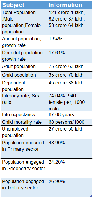
Source: Economic Survey:2614-15 (Govt. of India)
Concept Of Population Growth And Sustainable Development
The concept of Sustainable Development was accepted by the developed countries of the West in the decade of 1970.
Sustainable development is possible when population growth will keep pace with the supply of the resource in the country.
But overpopulation or population explosion will create excessive population pressure on land which, ultimately, leads to detrimental changes to water, air, soil and other non-renewable resources on the earth.
Consequently, there will be a great challenge to the existence of man, animals, plants, agriculture, industry, and culture leading to a threat to the civilisation and sustainability of a pollution-free environment.
The time has come to save the earth to provide a fair shelter for future generations. and this can only be achieved with a mission of Sustainable Development.
In 1901 population of India was about 24 crores. After 100 years, in 2001 it increased to nearly 103 crores i.e. with the rate of 330%.
In the last census of 2011, it was 121-01 crores. So in near future in India, it will be difficult to maintain the sustainability of progress and development unless the growth rate of the population is lowered or restricted within the limit of natural resources.
Factors Influencing Regional Distribution Of Population In India
The distribution of the population in India is very much uneven. Such uneven regional population distribution is due to the following factors:
1. Physical factors which influence: The distribution of population in India are
Landform:
The population is high in the Gangetic plains and in the river valleys of the south due to flat land. But it is low on high mountains and over the plateaus because of rugged topography.
Rivers:
River valleys of Ganga, Brahmaputra, Mahanadi, Godavari, Krishna, and Kaveri provide a regular supply of water to the industries, and farmlands; for navigation, irrigation as well as drinking purposes.
Climate:
The coastal location of Andhra Pradesh, Tamil Nadu, and Kerala are densely populated because of the congenial climate whereas the desert in Rajasthan is sparsely populated due to the extreme types of climate.
Soils:
The population is dense in the black cells of Maharastra and the fertile soils of river valleys.
Natural Vegetation:
Forested areas of the western slopes of the Western Ghats and foothills of the Himalayas do not provide any room for settlements.
Minerals:
Mining towns have developed in the Deccan plateau and in the Chota Nagpur plateau for job facilities.
2. Economic factors which influence: The distribution of population are
Transport System:
The Plains of North India are well populated for the road-rail network as well as waterways.
Industries:
Hugli Industrial Region or Asansol Industrial Region are well populated as the industries provide jobs to many people.
3. Cultural factors like the conversion of dry and fallow land into fertile green land are good examples of population concentration. Green Revolution has changed the scenario of Punjab, Haryana and east Rajasthan.
WBBSE Chapter 5 India Economic Environment Concept Of Density Of Population
The density of the population indicates population pressure on land which is very much high in India. It is derived as:
map
\(\text { Density of population }=\frac{\text { Total population }}{\text { Total area }}\)According to the 2011 census, the density of the population in India is 382 persons per sq. km.
Amongst 29 states, the density of population is highest in Bihar (1102/sq. km), West Bengal has the second highest density (1029/sq km) and Kerala is the third in the density of population (859/sq. km) in India.
Amongst Union Territories, the density of the population is highest in Delhi (11,282/sq km) Amongst the states of India, the density of the population is lowest in Arunachal Pradesh.
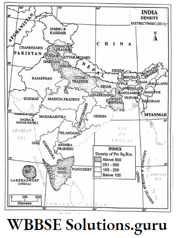
Density regions
Based on the density of population, 29 states and 7 unions Territories of India may be grouped into four probable density regions
- The thickly populated region includes 7 states like Bihar, West Bengal etc. and 5 union territories like Delhi, Chandigarh, Puducherry etc. where the density of
- the population is above 500 persons per square km.
- The moderately populated region includes 10 states like Jharkhand, Assam, Goa etc. where the density of population is 251-500 persons per square km.
- The thinly populated region includes 9 states like Uttarakhand, Chhattisgarh, Meghalaya etc. where the density of the population is 101-250 persons per square km.
- The sparsely populated region includes the states of Mizoram, Arunachal Pradesh and Sikkim and the Union Territory of Andaman Nicobar Island where the density of population is 100 persons or less per square km.
Causes Of Urbanisation
A Town may be defined as a settlement which has factories, pucca houses and metalled roads, a good transport network with the facilities of water and electricity supply and is inhabited by people engaged in non-agricultural activities.
A town with a population of at least 1 lakh is called a city. A city with a population of more than 10 lacks is called Metropolis.
Various physical and economic causes, either, individually or in combination are responsible for urbanisation, such as
- The administrative centre may gradually develop into a town like Chandigarh.
- Mining centres like Asansol,
- Communication centres like Siliguri,
- An industrial centre like Jamshedpur,
- Naval bases like Meerut,
- Religious centres like Varanasi,
- Health Resort likes Darjeeling.
- Centre of education and culture like Aligarh,
- A historical centre like Agra,
- Trading centres like Hapur in Uttar Pradesh,
- Tourist centres like Shimla and
- Port-like Paradwip.
Problems Of Urbanisation In India
Since independence, due to the rapid growth of population, the existing towns and cities are expanding in India as well as settlements centring industries and ports are transforming into new towns and cities.
At present, most of the cities and towns are facing problems like unplanned urbanisation-excepting cities like Chandigarh most of the Indian towns and cities have developed in an unplanned manner.
So houses, offices, institutions etc. have developed haphazardly in a town or a city. So these towns and cities are clumsy and deteriorating.
1. People’s Tendency To Settle In Cities:
To lead a better lifestyle, job opportunities and developed civil services are more in cities and towns than in villages.
So most Indians prefer urban centres for their dwellings. This leads to scarcity of space, the formation of slums and squatters and the spread of diseases.
2. Lack Of Infrastructure:
Population pressure on land results in weak infrastructure. Most of the cities and towns are facing the problems of lack of infrastructure and crises in health, education, electricity and drainage, and sewerage system.
WBBSE Chapter 5 India Economic Environment Transport And Communication System Of India
The movement of goods and passengers from one place to another by vehicles through different routes is known as Transportation.
The exchange of news and information is known as Communication. Letters, telephone, telegram, internet are the mode of transport.
Importance Of Transport
In a developing country like India, the transport network is important like an arterial system of the human body. It is so important because,
1. Development Of Domestic And International Trade:
Import-export activities of different parts of the country as well as with other countries are only possible through a good transport network.
2. Development Of Industries:
The transport system plays a vital role to carry raw materials and finished goods from an industry.
3. Distribution Of Resource In Every Corner Of A Country:
The transport system is indispensable for the distribution of cotton goods, and food grain in different parts of the country.
4. Extraction of natural resources:
To extract minerals and collection of forest products transport system is very much necessary.
5. To combat natural calamity:
Without a well-knit transport system, it is not possible to combat calamities like floods, droughts, cyclones, tsunamis and earthquakes.
6. Development of backward areas, defence of the country, development of education and culture and development of tourism mostly depend on the good transport network of a country.
Modes Of Transport
Modes or different routes of transport in India are as follows:
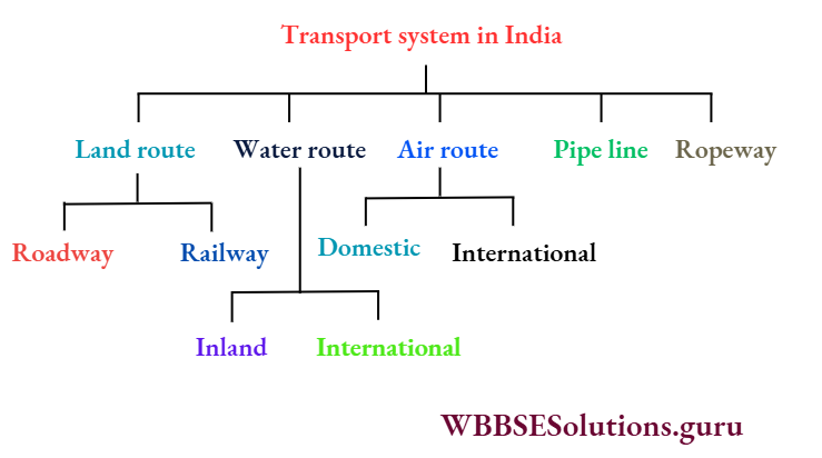
Importance Of Railways And Roadways:
Railways
Railways in India were initiated with the construction of 33-6 km long railway lines between Mumbai and Thane on 16th April 1853.
Now it has been extended to about 65,000 km India ranks 1st position in Asia and 2nd position in the World railway system. Railways play an important role as follows:
- Railways play an important role in the internal transport system because it is only possible for railways to transport heavy and bulky items in remote places of India and it is also a cheap and quick means of transportation.
- Agricultural progress in India depends on railways because excess agricultural products of one region are transported quickly to the regions where there is scarcity.
- There is no alternative to bringing raw materials to the factory and sending finished goods to the market quickly.
- Ports are connected with different parts of India by railways. So Railways play an important role in the import-export trade of India.
- Railways also play an important role in defence, sending various items to disaster-prone areas.
Roadways
In roadways, India ranks 3rd. position in the world. The total length of roadway in India is about 44 lacks 20 thousand km.
Roadways play an important role in the overall development of a developing country like India, because of the development of rural areas (villages are connected with roadways), utilisation of minerals, and development of the hilly regions.
Development in trade and deference mostly depend on roadways. Roadways are of different types-National Highway, State Highways, District Highways, Village roads etc.

National Highway
National Highways connect one end to another end of the country. It is about 70 thousand 934 km long in India. It is maintained by Central Government.
It connects major cities like Delhi, Mumbai, Chennai, and Kolkata. It includes two important parts
- Golden Quadrilateral and
- North-South and East-West Corridor.
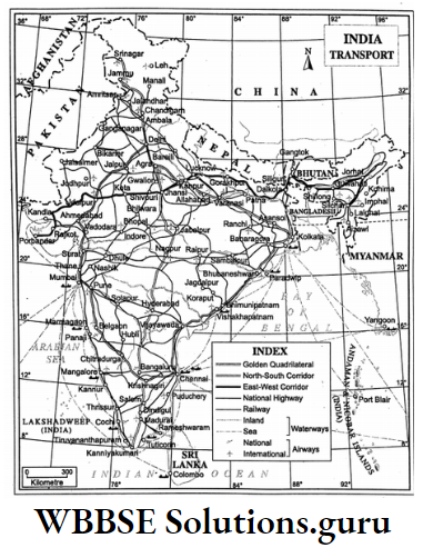
1.Golden Quadrilateral:
In 1999, India Government undertook a project, namely, National ‘Highways Development Project’ in which there was a plan to connect four metropolises, Delhi-Kolkata-Chennai-Mumbai by Six lane National Highways.
This is known as Golden Quadrilateral. The project was completed by 31st May 2005. Under this project, the length of the roadway was 5846 km.
2. North-South And East-West Corridor:
Along with the Golden Quadrilateral, India 20 Government undertook another project to connect Srinagar in the north to Kanniyakumari.
In the south and Silchar in the east to Porbandar in the west by National Highways, the length of which is 7300 km.
There are many National Highways in India, such as Grand Trunk Road (NH-2), Kolkata-Mumbai (NH-6), Agra-Mumbai (NH-3), Mumbai–Chennai (NH-4) etc.
State Highways:
State Highways extend within the state boundaries and are connected with National Highways. These are under State Government.
The total length of State Highways is 1 lakh 32 thousand km. Example. Assam Link Road, Jessore Road in North 24 Parganas etc.
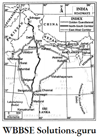
WBBSE Chapter 5 India Economic Environment Waterways
The cheapest mode of transport is the waterway. Except can always there is no constructional cost for the waterway. Waterways are of two types
- Inland waterway and,
- Coastal (Sea) waterway. It also saves fuel costs.
Inland Waterway
Navigable rivers, lakes and lagoons, canals are used as waterways in India. The Inland waterway in India estimates at about 14,500 km.
River includes 3700 km and canals include a 4300 km route in which a steamer is used for the transport of passengers in canals. Boats are used for transport in rivers as well as canals.
Coastal (Sea) waterways
The peninsular location of India helps International trade with Egypt, Greece, and Rome through coastal waterways since ancient times. At present, in India, there are 12 ports in coastal locations. These are:
East coast:
- Kolkata-Haldia (West Bengal),
- Paradwip (Odisha),
- Visakhapatnam (Andhra Pradesh),
- Chennai (Tamil Nadu),
- Tuticorin (Tamil Nadu),
- Ennore (Tamil Nadu).
West Coast:
- Kandla (Gujarat),
- Mumbai (Maharastra),
- Jawaharlal Nehru Port (Maharastra),
- Marmagaon (Goa),
- Mangalore (Karnataka) and
- Cochi (Kerala).
Airways
Air transport is the fastest mode of transport. Remote places, rugged terrain, desert, and jungles all are accessible by airways. Indian airway is of two types
- Domestic or National Airways and
- International Airways.
Domestic Airways
Alliance Airline under ‘Indian Airlines Corporation’ operates domestic Aircraft. IndiGo, Jet Airways, Go Air, and Spicejet are private organisations which operate domestic aircraft.
Domestic airports are Koch Bihar, Balurghat, Bagdogra, Andal in West Bengal; Dehradun, Panthnagar in Uttarakhand; Agartala in Tripura; Tuticorin, Salem, Madurai in Tamil Nadu; Hirakund, Bhubaneswar, Berhampore in Odisha.
Dimapur in Nagaland, Aizawl in Mizoram; Imphal in Manipur; Sholapur, Ratnagiri, Nasik, Kolapur, Jalgaon in Maharastra; Jabbalpur in Madhya Pradesh; Mysore, Belgaon in Karnataka; Ranchi, Jamshedpur, Dhanbad in Jharkhand.
Jammu in Jammu and Kashmir; Kulu, Shimla, Kangra in Himachal Pradesh; Surat, Rajkot, Porbandar, Bhavnagar, Kandla, Vadodara in Gujarat; Diu in Daman and Diu.
Raipur in Chhattisgarh; Patna in Bihar; Tejpur, Dhubri, Dibrugarh in Assam; Port Blair in Andaman Nicobar Islands.
International Airways
Air India, Government airways operate International Airways. International airports (Netaji Subhas Chandra Bose) are Kolkata (Dum Dum) in West Bengal; Hyderabad in Telangana; Guwahati in Assam.
Gaya in Bihar; New Delhi; Ahmedabad in Gujarat; Bangaluru and Mangalore in Karnataka; Cochi, Kojhikod and Tiruvanantapuram in Kerala; Bhopal and Indore in Madhya Pradesh; Mumbai, Nagpur.
Pune in Maharastra; Shillong in Meghalaya; Jaipur in Rajasthan; Chennai, Coimbatore, Tiruchirapalli in Tamil Nadu, Lucknow in Uttar Pradesh, Visakhapatnam in Andhra Pradesh, Bhubaneswar in Odisha and Amritsar in Punjab.
Other Transportation System
In the transport system of India ropeway, pipeline and underground railways (metro) also play very important roles.
Ropeway:
Ropeway is used to access difficult places where railways and roadways cannot reach. It is used in the Damodar Valley coal belt, and in Darjeeling, Joshimath, and Hardwar for recreation.
Pipeline:
Mineral oil and natural gas are transmitted by pipelines. Through pipelines, petroleum is transported from oil fields to oil refineries. A pipeline connects Haldia and Barauni, Naharkatia and Barauni etc.
Underground Railway:
To avoid crowds on roadways underground railway or metro started first in Kolkata. Now it is operating in Chennai, Delhi, Mumbai, Jaipur, and Hyderabad.
WBBSE Chapter 5 India Economic Environment Modern Communication System
The ancient mode of communication was the Postal facility which is a very much slow means of communication. To keep pace with the fast lifestyle, modern modes of communication systems have evolved, such as
- Internet,
- E-mail and
- Cell-phone.

1. Internet:
World wide Communication system is known as the Internet. At present about 100 countries are connected through Internet systems.
Vannevar Bush, Norbert Wiener and Marshall McLuhan are the founders of this concept. Since 1990, the Internet system was spread out in India.
The medium of Internet communication is satellite and telecommunication systems. The Internet system is the quickest and cheapest communication system.
2. E-mail:
Electronic mail or e-mail is an important part of the Internet communication system. News is sent to any place in the world within a second.
3. Cell phone:
This is a mobile wireless communication system. SMS (Short Message Service), MMS (Multimedia Messaging Service), and Mobile banking are special features of cell- phones.