WBBSE Notes For Class 9 Geography and Environment Chapter 3 Determination Of Location Of A Place On The Earths Surface

Chapter 3 Determination Of Location Of A Place On The Earths Surface Introduction

In a classroom, location i.e. placement of students usually referred to as first bench second bench etc. Similarly, you may like to refer to your village as east or west of the nearest rail. station or a pond.

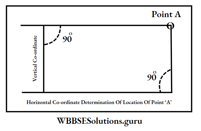
It is easy for you to locate a place on a flat surface with the help of intersecting two sets of lines-vertical and horizontal lines.

Read And Learn Also WBBSE Notes For Class 9 Geography and Environment

But on a spherical earth, it is difficult to pinpoint a place on an uneven surface.

WBBSE Notes For Class 9 Geography and Environment Chapter 3 Determination Of Location Of A Place On The Earths Surface Location Of Point 'O'

WBBSE Notes For Class 9 Geography And Environment Chapter 3 Determination Of Location Of A Place On The Earths Surface

Necessity Of Determination Of The Location Of A Place On The Earths Surface

It is necessary for a tourist or a traveller to know the location of countries, cities, towns, and villages in our world.

Location of a place also gives the idea of local time, weather, natural vegetation even the livelihood of man. Also for navigation, it is important to find out the exact location of a ship.

WBBSE Notes For Class 9 Geography and Environment Chapter 3 Determination Of Location Of A Place On The Earths Surface Horizontal Co-Ordinate

WBBSE Class 9 Geography And Environment Chapter 3 Notes

Chapter 3 Determination Of Location Of A Place On The Earth’s Surface Latitudes

Concept Of Latitude

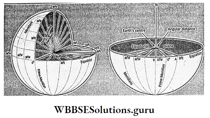
On Spherical earth, the exact location of a place is determined by an angular distance which is expressed in degrees, minutes and seconds.

On the spherical earth, the exact location of a place is determined with the help of two Imaginary lines known as Parallels of latitude and Meridians of longitude.

On a map of Atlas and Globe, the intersecting east-west and north-south lines are drawn which together form a geographical grid and are used to find out the exact location of a place.

WBBSE Solutions For Class 9 Fundamentals Of HistoryWBBSE Class 9 English Functional Grammar
WBBSE Class 9 Fundamentals Of History Long Answer QuestionsWBBSE Class 9 English Reading Skill
WBBSE Class 9 Fundamentals Of History Short Answer QuestionsWBBSE Class 9 English Writing Skill
WBBSE Class 9 Fundamentals Of History Very Short Answer QuestionsWBBSE Class 9 Maths Multiple Choice Questions
WBBSE Class 9 Fundamentals Of History Multiple Choice QuestionsWBBSE Solutions For Class 9 Maths
WBBSE Notes For Class 9 Geography and Environment

Parallels Of Latitudes

Imaginary lines drawn in the east-west direction encircling the globe are called Parallels of latitude. The most important of these lines is the Equator.

Equator

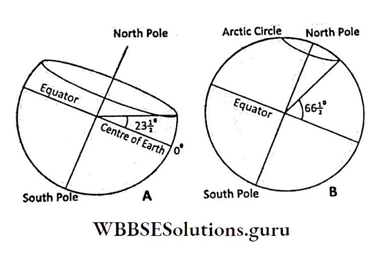
It is an east-west extended Great circle running midway between the two poles. The plane formed by the equator is called Equatorial Plane.

Latitude

This is the angular distance of a place measured from the centre of the earth either north or south of the equator on the
equatorial plane.

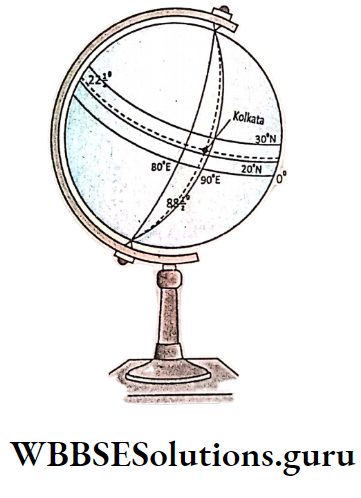
The Latitude of Kolkata is 22°30′ north means Kolkata is located at 22°30′ angular distance to the north of the equatorial plane.

WBBSE Notes For Class 9 Geography and Environment Chapter 3 Surface Tropic Of Cancer

Parallels Of Latitude

Imaginary lines drawn parallel to the equator to the north and south are known as Parallels of Latitude. These are full circles and extended in east-west directions.

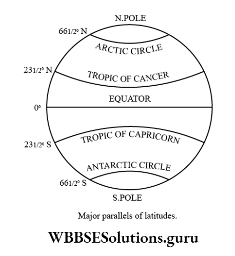
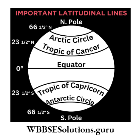
Each line joins all the places having the same latitude. They vary from 0° (equator) to 90° (poles).

1. Importance Of Parallel Of Latitude:

Parallels of latitude help us in finding the location of a place how far to the north or south of the equator. Sunrays are Inclined away from the equator.

So temperature decreases with increasing latitude. Therefore, latitudes help us to identify the climate. They divide the earth. into Thermal belts or Heat Zones.

WBBSE Notes For Class 9 Geography and Environment Chapter 3 Parallels Of Latitude

2.Properties Of Parallels Of Latitude:

Except for the two poles all the parallels of latitude run in the east-west direction. All parallels are full circles. All of them are parallel to each other.

All parallels are not of equal sizes. They decrease in size from the equator to the poles into points. The equator is the largest one and forms a Great Circle.

The linear distance between two parallels at a 1° interval is more at the polar region because of the oblate spheroid shape of the earth. All places on a parallel of latitude in either hemisphere have latitudes of the same value.

The sum of all the latitudes of each parallel is always 360°. The angular distance between the equator and the pole is 90°.

WBBSE Notes For Class 9 Geography and Environment Chapter 3 Parallels Of Latitude equator

WBBSE Class 9 Geography And Environment Chapter 3 Notes

Important Parallels Of Latitudes And Their Uses

1. Equators:

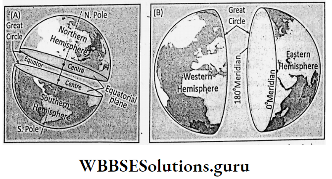
The Equator runs midway between the north pole and the south pole encircling the earth in an east-west direction. Its value is 0°. It divides the earth into two equal parts- the northern hemisphere and the southern hemisphere.

It helps us identify the location of a place in which hemisphere and how far from the equator a place is located. The latitude of any place is also measured in angular distance from the equator.

2. Tropic Of Cancer And Tropic Of Capricorn:

Parallels of latitude located at 23°30′ north and 23°30′ south of the equator are known as the Tropic of Cancer and Tropic of Capricorn respectively.

Tropic of Cancer is the northern limit of the apparent annual movement of the sun. The Tropic of Capricorn is the southern limit of the apparent annual movement of the sun.

3. Arctic Circle And Antarctic Circle:

Parallels of latitude located at 66°30′ north and 66°30′ south of the equator are known as the Arctic Circle and Antarctic Circle respectively.

On the 21st of June, it is 24 hours daily from the Arctic Circle to the north pole and 24 hours a night from the Antarctic Circle to the south pole. On 22nd December opposite conditions prevailed.

Identification Of Heat Zones Or Belts By Latitudes

The inclination of sunrays falling on the earth’s surface varies at different latitudes.

Temperature decreases away from the equator with the increasing inclination of the sunrays as vertical rays over the equator concentrate on a small area and travel shorter distances in the atmosphere and inclined rays spread over wide areas away from the equator and travel a longer distance in the atmosphere.

Accordingly, the earth may be divided into three thermal belts

  1. Torrid belt in between 23°30′ N and 23°30′ S.
  2. Temperate belt extending from 23°30′ N to 23°30′ S and from 23°30′ N to 23°30′ S latitudes.
  3. Frigid belt from 66°30′ N to North pole and from 66°30′ S to South pole.
WBBSE Notes For Class 9 Geography and Environment Chapter 3 Thermal Belts

Chapter 3 Determination Of Location Of A Place On The Earths Surface Longitudes

Concept Of Longitudes

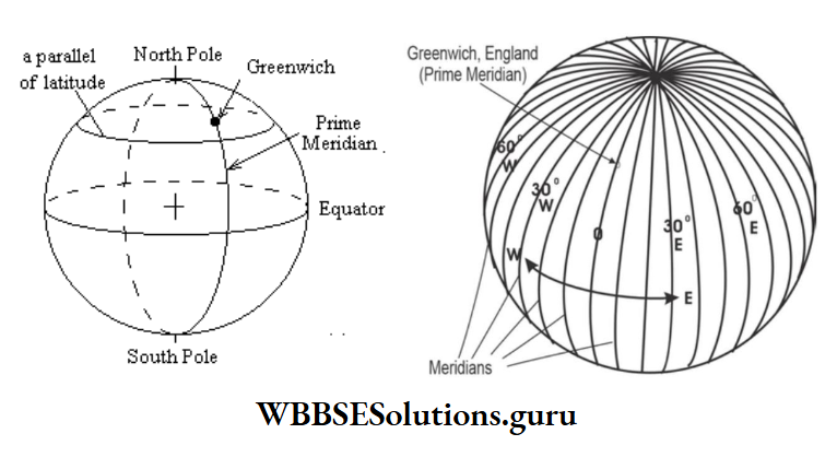
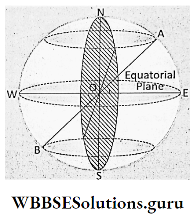
North-south extended lines joining the north and south poles are known as Meridians of longitude.

Prime Meridian

In 1884, by an international agreement, the meridian passing through the Royal Observatory at Greenwich near London was chosen as the Prime Meridian. Its value is 0°.

It is also known as Greenwich Meridian. Prime Meridian together with its opposite meridian i.e. 180° forms a full meridian or the Great Circle.

It divides the earth into two equal eastern and Western hemispheres. Prime Meridian helps us to determine how far east or west Prime Meridian has located a place.

The local time of Prime Meridian is considered Greenwich Mean Time or G.M.T. which is granted as Standard Time for the whole world.

WBBSE Notes For Class 9 Geography and Environment Chapter 3 Prime Meridian

Longitude

Longitude is the angular distance of a place measured, either east or west of the Prime Meridian that passes through Greenwich on the equatorial plane with its apex being the centre of the earth.

WBBSE Notes For Class 9 Geography and Environment Chapter 3 Angular Distance Of Longitude, Meridian

WBBSE Class 9 Geography And Environment Chapter 3 Notes

Chapter 3 Determination Of Location Of A Place On The Earth Surface Meridians Of Longitude

Semi-circular imaginary lines joining the north and south poles extending in a north-south direction over the earth’s surface are called Meridians of Longitude.

Each Meridian connects all the places having the same longitude in the eastern or western hemisphere. Their value increases from the prime meridian (0°) to a maximum of 180°.

Properties Of Meridians Of Longitude

All the Meridians of Longitude run in a north-south direction. Each meridian is a semi-circle and consists of a sum of 180° longitudes.

All of them are not parallel to one another. The linear distance between two adjacent meridians decreases from 111 km at the equator to 0 (zero) km at the poles.

The angular distance of meridians of longitude increases to the east as well as to the west up to 180°. But 180° E and 180° W longitudes together form one meridian.

In both hemispheres meridians of the same value are found. Each meridian and its anti-meridian together form Great Circle and their centres coincide with the centre of the earth.

All places located on the same meridian have the same longitude and the same local time. On the 21st of March and 23rd of September all places on a particular meridian experience sunrise, noon and sunset at the same time.

Important Meridians And Their Uses

Prime Meridian :

Prime Meridian is used to find out whether a place whether located in the Eastern Hemisphere or Western Hemisphere. It is also used to find out the Greenwich Mean Time or G.M.T. i.e. World Standard Time.

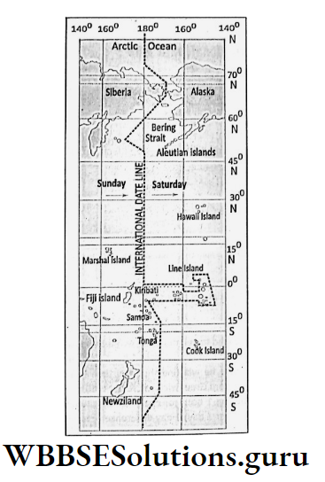
International Date Line Or 180° Meridian :

180 meridian is known as International Date Line. Crossing this meridian a day is either added or subtracted from the calendar.

Standard Meridian :

Most of the countries have selected a centrally extended meridian the local time of which is followed as Standard Time by the whole country.

Longitude And Time :

Longitudes are closely related to time. The earth is round with its circumference producing 360° at the centre and the earth completes a rotation around its axis in front of the sun in 24 hours.

Actually, the earth takes 24 hours to turn its 360 longitudes around its axis in front of the sun. So, in one hour (360 ÷ 24 = 15°) there is a turning of 15° longitudes. Similarly, 1° longitude turns in (60 minutes ÷ 15 = 4) 4 minutes.

WBBSE Class 9 Geography Chapter 3 PDF

The Relation Between Longitudes And Time Is Reflected In The Following Concepts

Local Time:

The local time of a place is determined in reference to the position of the sun in relation to its longitude. When the sun lies overhead of a place the local time of that place will be 12 noon or mid-day.

The local time is the same for all the places on the same meridian. This is also known as Sun time as it is determined with the help of the position of the sun.

WBBSE Notes For Class 9 Geography and Environment Chapter 3 Determination Of Location Of A Place On The Earths Surface Equatorial Plane, Determination Of Latitude

A.M. And P.M. (Ante Meridian And Post Meridian) :

The local time of any place between midnight and midday is called Ante Meridian or A.M. while the local time of place from mid-day to midnight is known as Post Meridian or P.M.

Standard Time:

If all the places of a country follow their local time then the people moving from place to place would have to adjust their watches to their respective local time.

To avoid such confusion most of the countries have selected a central meridian the local time of which is followed by the whole country.

Such a centrally extended meridian is called Standard Meridian and the local time of that meridian is known as Standard Time. The local time of 82°30′ east longitude in India is known as Indian Standard Time or I.S.T.

The longitudinal extension of India is 68°07′ to 97°25′ east. Accordingly standard meridian should be 82°46′ east.

But as the lowest limit of variation in standard time is 7°30′ longitude or 30 minutes time, so counting from Greenwich (0°) longitude standard time of India is 82°30′ east. The time difference between Greenwich and India is 5 hours and 30 minutes.

WBBSE Class 9 Geography Chapter 3 PDF

Chapter 3 Determination Of Location Of A Place On The Earths Surface Geographical Grid To Find Location

East-west extended parallels of latitude and north-south extended meridians of longitude intersect each other to form a network or the Earth’s Grid which helps to locate a place on the Earth’s surface.

The point at which the parallel of latitude and meridian of longitude intersect is the exact location of a place on the earth’s surface.

Thus the location of Kolkata is the intersecting point between two lines 88°30′ east. longitude and 22°30′ north parallel of latitude.

WBBSE Notes For Class 9 Geography and Environment Chapter 3 Determination Of Location Of A Place On The Earths Surface Location Of Kolkata On a Globe

Concept Of Great Circle

Great Circle is an imaginary circle drawn on the Earth’s surface. This is the largest possible circle. The Centre of the circle coincides with the centre of the earth.

It divides the earth into two equal halves. Amongst the parallels of latitude, only the Equator is the Great Circle as this is the largest circumference of the earth coinciding its centre with the earth’s centre and dividing the earth into two hemispheres.

Similarly, the Prime Meridian and its antipodal meridian i.e. 180° longitude together, form another Great Circle also.

WBBSE Notes For Class 9 Geography and Environment Chapter 3 Determination Of Location Of A Place On The Earths Surface Great Circle

WBBSE Class 9 Geography Chapter 3 PDF

Chapter 3 Determination Of Location Of A Place On The Earths Surface Concept Of Antipodes And International Date Line

1. Antipodes :

A place located diametrically opposite to another place on the earth’s surface is said to be the Antipode to the latter place. Therefore, two ends of an imaginary diameter of the earth are mutually antipodal to each other.

Antipodal places have the same latitude but they belong to opposite hemispheres. Example. latitude of Kolkata is 22°30′ north. So the latitude of its antipode will be 22°30′ south.

The difference in longitude between the antipodal places is 180° as antipodal places are located on opposite meridians.

WBBSE Notes For Class 9 Geography and Environment Chapter 3 Determination Of Location Of A Place On The Earths Surface Antipodal Position Of Place 'A' And 'B'

2. International Date Line :

There is great confusion and inconvenience to those who travel around the world. Suppose, a traveller moving eastwards from Greenwich at 10 a.m.

on Sunday will gain 1 hour for every 15° longitude until he reaches the 180th meridian where he will find the local time being Sunday 10 p.m. Another person on his westward journey from Greenwich will find it is 10 p.m.

Saturday on reaching the 180th meridian as he was losing 1 hour for every 15° longitude. Therefore, there is a total (12 hours + 12 hours = 24 hours or 1 day) 1-day difference between the two travellers.

So on crossing the 180th meridian a person in a ship or aircraft moving eastward will have to deduct one day, while moving westward will have to add one day in his calendar.

To avoid such confusion, Prof. Davidson took initiative to hold the ‘International Meridian Conference’ in Washington USA in 1884 where this 180th meridian was chosen as International Date Line or IDL.

International Date Line deviates either eastward or westward at some places from the 180th meridian to avoid the landmasses, for Example. Rangal Island, Aleutian Island, Fiji, Chatham etc.

Chapter 3 Determination Of Location Of A Place On The Earths Surface Mathematical Calculations On Longitudes And Time

There is 4 minutes time difference for a difference in longitude of 1°. Similarly, there is a 1-hour time difference for a difference in longitude of 15.

Therefore, places located to the east of the other place have their local time ahead of that place and the places located to the west of the other place have their local time behind that place.

So the difference in time will be added when the places in question are located to the east. It will be deducted if the place in question is situated to the west of the other place.

Mathematical Calculation For Finding Longitude And Time:

Mathematical Rules

1. Finding Of Longitude From Given Time:

If the time of a given place is ahead of that of Greenwich then the place must lie to the east and if it is behind that of GMT then the place will be located to the west of Greenwich.

The time. difference between two places found in minutes is to be divided by 4 to get the longitude of a place.

2. Finding Of Time From Given Longitude:

  1. Places lying to the east have their local times ahead of those places lying to the west and the places lying to the west have their local time lagging behind of those places lying to the east.
  2. Time 450 difference may be obtained by multiplying the longitudinal difference with 4.
  3. The time difference is added (+) when the place is located to the east and it is subtracted (-) when it is located to the west.

3. Finding of longitudinal difference:

  1. If two places lie on either side of Greenwich, longitudes of both hemispheres are to be added.
  2. If the places are located in the same hemisphere the lesser value is to be subtracted from the longitude of the higher value.

4. On crossing the International Date Line:

  1. On crossing the International Date Line from the west to the east 1 day will be added to the calendar, while crossing the International line from the eastern hemisphere to the western hemisphere 1 day is to be deducted from the calendar.
  2. On crossing the IDL eastward one day is gained but time is lost, while on crossing the IDL from the eastern hemisphere to the western hemisphere one day is lost but time is gained.

WBBSE Notes For Class 9 Geography and Environment Chapter 3 Determination Of Location Of A Place On The Earths Surface International Date Line

Mathematical Laws

1. 1° longitude is divided into 60 minutes (60°) and 1-minute longitude is subdivided into 60 seconds (60″).

2. When time is calculated

1. For 24 hours time difference longitudinal difference is 360°

∴ 1 hours time difference longitudinal difference is 360 ÷ 24 hours = 15°

2. For 15° longitudinal difference time difference is 1 hour or 60 minute

∴ 1° longitudinal difference time difference is 60 minutes ÷15° = 4 minutes

3. For 1° or 60′ longitudinal difference time difference is 4 minutes or 240 seconds

∴ 1’ or 60′ longitudinal difference time difference is 240 sec ÷ 60 = 4 sec

4. For 1′ or 60″ longitudinal difference time difference is 4 seconds

∴ 1” or 60” longitudinal difference time difference is 4 ÷ 60 or 1 ÷ 15 sec

[For 15 seconds (15″) longitudinal difference time difference is 1 second, for 30 seconds (30″). longitudinal difference time difference is 2 seconds.]

WBBSE Notes for Class 9 Geography Chapter 3

Problem-1:

It is 8 a.m. at Kolkata (88°30’E / 22°30’N) on Thursday 1st March 2012. What will be the local time, day and date on its antipode?

Solution :

The longitude of the antipode of Kolkata is 180°− 88°30’E = 91°30’ west

The difference in longitudes between Kolkata and its antipode is 91°30’ + 88°30’ = 180°

The difference in time for 1° longitude is 4 minutes

∴ Difference in time for 180° longitude is 180 × 4 = 720 minutes or 12 hours

So, the difference in time between Kolkata and its antipode is 12 hours.

As the antipode of Kolkata is located on West longitudes, so its local time will be behind that of Kolkata.

∴ When the local time of Kolkata is 8 a.m., Thursday, 1st March 2012, the local time, day and date of the antipode of Kolkata will be (8 a.m. − 12 hours) 2012 i.e. 8 p.m. i.e. 29th February, Wednesday (Leap year), 2012.

Problem-2:

A ship started its journey for Los Angeles (118° W) from Tokyo (139°E) on 30th June, Monday at 10 a.m. It crosses the Pacific Ocean by every meridian in 4 minutes. At what time, day and date the ship will reach Los Angeles?

Solution :

Difference in longitudes between Tokyo and Los Angeles is 180° − 139° = 41° and 180° − 118° 62° i.e. 41° + 62° = 103°

For 1 difference in longitude difference in time is 4 minutes

∴ 103° difference in longitude difference in time is 103 × 4 m = 412 m or,  6 hours 52 minutes.

As the east gains time, so, when the ship leaves Tokyo the local time at Los Angeles is (Monday 10 a.m. + 6 hrs. 52 minutes) Monday 4-52 p.m.

As Los Angeles is located to the west of the International Date Line, so, 1 day is to be deducted from the calendar. So, local time in Los Angeles will be Sunday from 4-52, pm.

The ship has taken 6 hours and 52 minutes to cross the Pacific Ocean for 103° longitudes. So, the time, day and date in Los Angeles are Sunday (4-52 pm + 6 hrs. 52 mins) 29th June at 11:44 pm.

Problem-3

When it is 9 a.m. in Greenwich the local time of place is 5 p.m. What is the longitude of that place?

Solution:

The difference in time between a place and a Greenwich is (9 a.m. − 5 p.m.) 480 minutes or 8 hours.

The difference in longitude for 4 minutes time difference is 1°

∴ The difference in longitude for 480 minutes time difference is 480 ÷ 4 = 120°

∴ The difference in longitude between that place and Greenwich is 120°.

As the local time of that place is ahead of that of Greenwich, the place is located to the east of Greenwich.
The longitude of the place is 120° East.

WBBSE Notes For Class 9 Geography and Environment Chapter 4 Geomorphic Processes And Landforms Of The Earth

Chapter 4 Geomorphic Processes And Landforms Of The Earth Introduction

Elementary Concept Of Geomorphic Processes

There is variation in size, shape and nature of the earth’s surface which is continuously formed by some internal or endogenetic and modified by some external or exogenetic forces, collectively known as Geomorphic processes.

WBBSE-Notes-For-Class-9-Geography-and-Environment-Chapter-4-Geomorphic-Processes-And-Landforms-Of-The-Earth-Elementary-Concept-Of-Geomorphic-Processes

Endogenetic forces are responsible for both slow and sudden changes in the earth’s surface by compression, tension, uplifting, subsidence, rifting, deformation etc. Excessive heat and intensive pressure of the earth’s interior are responsible for such forces.

WBBSE Notes For Class 9 Geography and Environment Chapter 4 Geomorphic Processes And Landforms Of The Earth

Slow Or Diastrophism

Millions of millions of years take to change the earth’s surface slowly. The resultant landforms are Mountain, Plateaus, and Plain. Diastrophism includes pyrogenic and orogenic movements.

Read And Learn Also WBBSE Notes For Class 9 Geography and Environment

Plateaus and continents are uplifted on the earth’s surface slowly by continent-building or pyrogenic force which acts radially or vertically in the earth’s interior. Resultant landforms include Rift Valley, Block Mountain, and submerged and emerged coasts. Mountains are formed by horizontal or lateral forces which act tangentially in the earth’s interior. Compression on soft rocks develops Fold mountains.

WBBSE Class 9 Geography And Environment Notes

Sudden Movement

Sudden changes on the earth’s surface are responsible for earthquakes, and vulcanism. Resultant landforms are volcanic mountains, lava plateaus etc.

Exogenetic forces are active on the earth’s surface and are continuously modifying the primary landforms produced by endogenetic forces through the agents of gradation (aggradation and degradation) like rivers. Glacier, wind, sea waves as well as weathering, and mass wasting produce landforms known as Sequential landforms.

WBBSE Solutions For Class 9 Fundamentals Of HistoryWBBSE Class 9 English Functional Grammar
WBBSE Class 9 Fundamentals Of History Long Answer QuestionsWBBSE Class 9 English Reading Skill
WBBSE Class 9 Fundamentals Of History Short Answer QuestionsWBBSE Class 9 English Writing Skill
WBBSE Class 9 Fundamentals Of History Very Short Answer QuestionsWBBSE Class 9 Maths Multiple Choice Questions
WBBSE Class 9 Fundamentals Of History Multiple Choice QuestionsWBBSE Solutions For Class 9 Maths
WBBSE Notes For Class 9 Geography and Environment

Chapter 4 Geomorphic Processes And Landforms Of The Earth Different Major Landforms Of The Earth

Landforms are the variation in size, shape, ruggedness, slope and nature of the earth’s surface, such as mountains, hills, plateaus, plains, lowlands, valleys etc.

Landforms are generally grouped into three categories

  1. Mountain,
  2. Plateau and
  3. Plain.

Lofty mountains occupy the central part of Asia. Southern and western parts of Europe and the western part of South America are also occupied by high mountain ranges.

Africa is a plateau continent. River valleys and coastal plains are almost common in each and every continent.

WBBSE Notes For Class 9 Geography and Environment Chapter 4 Major Landforms

WBBSE Notes For Class 9 Geography and Environment Chapter 4 Geomorphic Processes And Landforms Of The Earth Different Landforms

Mountains

Mountains Their Types:

An extensive area of the earth’s surface which rises over 1000 m above sea level with conical peaks, broad base, deep gorges and steep slopes is known as Mountain. Example. the Himalayas, Alps, Andes, Rockies etc.

Mountains are of four types based on their mode of formation-Fold mountains, Block (or Fault) mountains, Volcanic mountains and Residual mountains.

Fold mountains are formed due to the folding of soft sedimentary rock layers of the earth’s crust. Example. the Himalayas.

Displacement of raised blocks of rocks due to the fracture or fault produced on the earth’s crust by compressional or tensional forces on hard rocks form Block Mountain. Example. Satpura in India, Vosges in France.

WBBSE Class 9 Geography And Environment Notes

Aggradation of accumulated lava, ash and dust ejected from the magma chamber in the earth’s interior, eventually, develops volcanic mountains. Example. Mt Fuji in Japan, Barren in India.

Denudation or prolonged erosion of pre-existing mountains may, eventually, develop Residual or Relict mountains. Example. Appalachian of the USA and Aravallis in India.

Origins Of Fold Mountains (On The Basis Of Plate Tectonics)

There are several theories amongst which the most important is the Plate Tectonic theory regarding the origin of the Fold Mountains.

Plate Tectonic theory is the most modern theory which is an outcome of the investigation by the geologists T. Wilson, and D. P. Mackenzie.

D. L. Pichou, the father of the theory explained it in 1968. According to this theory, continental crust consists of seven big plates, eight medium plates and twenty small plates.

Seven big plates are

  1. Eurasian plate,
  2. Pacific Ocean plate,
  3. North American plate,
  4. South American plate,
  5. Indo-Australian plate,
  6. African plate and
  7. Antarctica plate.

Plates are separated by fault lines and extend up to 70 km below the ocean and 150 km below the continents. Along the margins of the plates where two plates meet are found the plate boundaries.

Plates are floating on the upper part of the Mantle i.e. Asthenosphere due to convectional current produced by great temperatures in the earth’s interior.

WBBSEClass 9 Geography Notes

They move very slowly about 1 or 2 cm per year. As these plates are moving, there are three types of plate boundaries, when two plates move towards each other they form

  1. Converging plate boundaries when two plates move away from each other they form
  2. Diverging plate boundary. When two plates cross each other along plate margins they form
  3. Neutral plate boundary.


WBBSE Notes For Class 9 Geography and Environment Chapter 4 Geomorphic Processes And Landforms Of The Earth Major Plates

Fold mountains are formed along the converging plate boundaries.

Converging plate boundaries are of three types

  1. Continental-Continental plate boundary,
  2. Oceanic- Continental plate boundary and
  3. Oceanic-Oceanic plate boundary.

When Two Continental:

continental plates move each other shallow sea or geosyncline in between them is filled up by the sediments deposited from the marginal plates.

The plates collide and horizontal pressure squeezes up the soft sedimentary rock layers of the sea floor into a series of folds to form great Fold mountains of the world.

Two plates, namely the Angaraland to the north and the Gondwanaland to the south of the ancient Tethys geosyncline moved towards each other to squeeze up the sediments of the Tethys seafloor into the great folds of the Himalayas.

WBBSE Notes For Class 9 Geography and Environment Chapter 4 Geomorphic Processes And Landforms Of The Earth Tethys Sea

Continental:

oceanic plates also develop Fold mountains. Two such plates when converge, and the denser oceanic plate sinks below the lighter continental plate.

Eventually, one geosyncline develops in front of the continental plate. Ultimately sediments are deposited on this sea from which the folds are squeezed up to form the great Fold mountains.

Example. Rockies and Andes have formed by the sinking of the Pacific Oceanic plate below the North and South American plate.

WBBSE Notes For Class 9 Geography and Environment Chapter 4 Geomorphic Processes And Landforms Of The Earth Fold Mountain and Origin of the Himalayas

WBBSE Notes For Class 9 Geography and Environment Chapter 4 Geomorphic Processes And Landforms Of The Earth Formation Of Fold, Anticline And Syncline

Characteristics Of Fold Mountains:

Fold mountains are of various types. Folds are either uphold or downfold. Faults are common in Fold mountains.

Fold mountains are made of sedimentary rocks and fossils are, therefore, found in Fold mountains. Most of their peaks are conical.

Chapter 4 Geomorphic Processes And Landforms Of The Earth Concept Of Old And Young Fold Mountains

According to the geologist Fold mountains have formed in three different stages and in between two consecutive stages there is one period of quiescence.

During the Paleozoic Period:

about 400 to 500 million years back the Caledonian Folds or the mountain system was formed. The mountains of Northern Ireland, Scotland and Scandinavia belong to this group.

WBBSEClass 9 Geography Notes

During Carboniferous Period:

about 220-320 million years back the Altitude or Hercynian mountain system was formed.

The Armorican and Hercynian mountain which stand to the south of the Caledonian, the mountain in Europe and the Appalachian mountain 3000 metres in North America belong to this group.

Urals of Russia, Aravallis of India, and Tien Shan and Nan Shan of China were also formed during this period.

During the Tertiary Period About 60 Sea Level To 70 Million Years Ago The Alpine Mountain:

the system was originated. It Caledonian stands to the south of the Altitude mountain system. The Alps, Himalayas, Rockies and Andes belong to this group and are known as Young Fold Mountains.

The Caledonian and the Altitude mountain systems are known as Old Fold Mountains.

At present, they are reduced to low and isolated plateaus due to denudation. Example. the Caledonian mountains of Europe.

WBBSE Notes For Class 9 Geography and Environment Chapter 4 Geomorphic Processes And Landforms Of The Earth Elementary Three Stages Of Fold Mountain

Origin Of Volcanic Mountains

Ejection of magma on the earth’s surface through the fractures called vents, results in the accumulation of lava, ash and dust.

Eventually, this accumulation of lava around the vent grows into a mountain called a Volcanic mountain or a Volcano. These are also known as the Mountain of accumulation.

WBBSE Geography Notes Pdf

Example. Fujiama in Japan, Vesuvius in Italy, Mauna Loa (Highest in the world) in Hawaii island, and Barren and Narcondam in the Andaman-Nicobar islands of India.

WBBSE Notes For Class 9 Geography and Environment Chapter 4 Geomorphic Processes And Landforms Of The Earth Volcanic Mountain Along the Plate Boundary

Most of the volcanoes of the world are located along plate boundaries. Converging, diverging and neutral all three plate boundaries are separated by fault lines which are geologically very weak.

Excessive heat generated in the earth’s interior due to friction of plates melts rock. Huge gas is also formed which is also responsible for gushing out of magma through these weak zones.

Example. there is a string of volcanoes along the margin of the Pacific Oceanic plate.

Chapter 4 Geomorphic Processes And Landforms Of The Earth Features Of Volcanic Mountains

WBBSE Notes For Class 9 Geography and Environment Chapter 4 Geomorphic Processes And Landforms Of The Earth Crater Of Volcano

Based on the nature of the eruption Volcanic mountains are of three types. Active volcanoes are those which erupt in recent times. Again, these are of two types.

Active volcanoes with continuous eruptions are known as Incessant. Example. Vesuvius in Italy. Intermittent volcanoes are those when that erupt after a period of silence, for Example. Barren in India.

WBBSE Geography Notes Pdf

Volcanoes with signs of possible eruption in future are said to be Dormant, for Example. Mt. Fuji in Japan. Extinct volcanoes are those which erupted in pre-historic times without any hope of future eruption Example. Narcondam in India.

WBBSE Notes For Class 9 Geography and Environment Chapter 4 Geomorphic Processes And Landforms Of The Earth Cone Shaped And Dome Shaped Volcanos

Based on shape and structure, volcanoes are of four types. Cone-shaped volcanoes are conical in shape Example. Mt. Fuji in Japan. Dome-shaped volcanoes are found in Hawaii island.

Volcanoes with explosive craters are found in Iceland. Volcanoes with Composite craters are those which have secondary craters besides the main one, e.g. Popacatapetl in Mexico.

Volcanoes are generally conical in shape with steep slopes. At the top is found the crater or mouth. Bigger ones have more than one crater. Crater is connected by a vent to the magma chamber.

WBBSE Notes For Class 9 Geography and Environment Chapter 4 Geomorphic Processes And Landforms Of The Earth Explosive And Composite Crater Volcanos

Origin And Features Of Block Mountains

Compressive and tensional forces produced by earth movements are responsible for the formation of cracks, or fractures when
applied on hard rocks.

This fracture is called Fault. As a result, rocks are displaced relative to one another on either side of this fault. The line along which this displacement of blocks of rocks takes place is called the Fault line.

WBBSE Geography Notes Pdf

Relatively raised blocks are called Block mountains or Fault mountains. Example. Satpura in Central India. Vosges in France, the Black Forest in Germany.

WBBSE Notes For Class 9 Geography and Environment Chapter 4 Geomorphic Processes And Landforms Of The Earth Block Mountain & Rift Valley

Block mountains originated in four ways. When a block of rock between two parallel fault lines is raised, upthrust causes the formation of the Block Mountains.

Example. Satpura. When a block of land in between two parallel fault lines subsides, down-thrust forms Block mountains on either side of the subsided block. Example. Vosges in France, the Black Forest in Germany.

Class 9 Geography Chapter 4 Solutions

When a block of land in between two parallel fault lines is raised but tilted, develops block mountains Example. Western Ghats of Southern India.

When two sides of parallel fault lines of an extensive plateau subside in relation to the central part it stands as Block Mountain.

WBBSE Notes For Class 9 Geography and Environment Chapter 4 Geomorphic Processes And Landforms Of The Earth Rift Valley Of River Rhine

Characteristics Of Block Mountain :

Block mountains are flat-topped with steep slopes. They are not as lofty as the Fold mountains nor do they stretch for a vast area. They are usually accompanied by Rift Valleys. Rapids and Waterfall are common along their steep slopes.

Chapter 4 Geomorphic Processes And Landforms Of The Earth Origin And Features Of Relict Mountains

Denudation of highlands develops low mountains known as Relict or Residual mountains. They are also known as the mountain of Degradation. Example. Appalachians of the U.S.A., the Urals in Russia, and Aravallis in India.

Prolonged erosion by exogenetic forces like rivers, glaciers, wind, sunshine etc.

May reduce any pre-existing mountains like Fold, Fault or Volcanic into low heights of the mountain with soft rocks being quickly eroded, while hard rocks stand as Relict or Residual mountains.

Old Fold mountains which have reduced to Relict mountains are Aravallis, Urals, Appalachian etc. Old plateaus also have turned into Relict mountains, such as Mahadeo and Maikal mountains in India.

Relict mountains have rounded tops with gentle slopes. They are not lofty. They are made of ancient rocks and are, therefore, stable. They are less rugged with wide river valleys.

WBBSE Notes For Class 9 Geography and Environment Chapter 4 Geomorphic Processes And Landforms Of The Earth Formation Of Residual Mountain

Importance Of Mountains

Mountains have great positive influences. The existence of mountains controls the climate. Example. The Himalayas obstruct the cold winds to enter India while giving rain by obstructing moist southwest monsoon wind.

Mountains are the source of big rivers like the Ganges, Indus and Brahmaputra. They help in the formation of extensive plains developed by the rivers that originated on their peaks. Mountainland is ideal for hydel power.

They help as well by protecting a country from foreign invasion. Mountains are rich in forest resources. Scenic beauties of the mountain land develop Tourism.

Class 9 Geography Chapter 4 Solutions

Mountains also affect adversely. As they are rugged, they do not favour agriculture. Mountainlands are also difficult to construct roadways as they are rocky and stony.

Mountains are sparsely populated. Mining is limited due to inaccessibility. Industries are also lacking.

Chapter 4 Geomorphic Processes And Landforms Of The Earth Plateau

Plateaus-Their Types:

Plateaus are steep-sided, flat-topped highlands with elevations, generally, varying between 300 and 600 m above sea level. Example. Plateau of Tibet, Brazilian plateau, Chotanagpur plateau etc.

Plateaus are extensive uplands. The top of a plateau is either flat or undulating. They are steep-sided and appear like tables. So they are also known as ‘Table land’.

Their height varies between 300 and 600 m above sea level. They have low relief. They may be old like the Deccan Plateau and young like the Tibetan Plateau. Old plateaus are resistant to erosion and are known as Shield.

WBBSE Notes For Class 9 Geography and Environment Chapter 4 Geomorphic Processes And Landforms Of The Earth Plateau

Plateaus are formed in three ways tectonics, erosion and deposition. During earth movements ancient landmasses were broken into separate plateaus, for Example. Deccan plateau, Arabian plateau.

Plateaus are also formed due to earth movements during the formation of Fold mountains, for Example. Intermontane Tibetan plateau.

During earth, movements upthrusted tilted Block may stand as a plateau. Dissected plateaus are formed by the erosion of high plateaus by rivers, glaciers, wind etc. Example. Chotanagpur plateau.

Plateaus are also formed by the deposition of Lava. Example. Lava Plateau or Deccan Trap of Maharashtra.

WBBSE Notes For Class 9 Geography and Environment Chapter 4 Geomorphic Processes And Landforms Of The Earth Based On Origin, Plateau Are Of Three Types

Intermontane Plateau

Due to earth movement, during the formation of Fold Mountain, plateaus are formed. These plateaus are actually enclosed by the Fold Mountains.

So they are called ‘Intermontane plateau which means ‘between mountains’. Example. The Tibetan plateau is enclosed by the Kunlun in the north and Karakoram in the south.

Class 9 Geography Chapter 4 Solutions

The Plateau of Iraq lies between Elburz in the north and Zagros in the south. The plateau of Anatolia in Turkey lies between the Pontic in the north and Tauras in the south.

Columbia and Yukon plateau of the north. America and the Bolivian plateau of South America have also formed this way.

WBBSE Notes For Class 9 Geography and Environment Chapter 4 Geomorphic Processes And Landforms Of The Earth Intermontane Plateau

Characteristics:

Intermontane plateaus are high and found in the young fold mountain region. It occupies an extensive area. Fossils are found in the plateaus. The climate is dry as they are surrounded by mountains.

Continental Plateau

Due to the earth’s movement, the ancient landmasses of the earth were broken and separated to form Continental blocks. These are Continental Shield.

Example.Deccan plateau of India, Siberian highland of Russia, Arabian plateau, African plateau, West Australian plateau, Brazilian highland, Canadian shield or Laurentian plateau.

Characteristics:

Continental plateaus are mostly made of ancient granite and Igneisses which are more than 1000 million years old. Mostly they have turned into Low plateaus.

Structurally, they are stable. Earth movements have no effects on them. Ancient igneous and metamorphic rocks of these plateaus are rich in minerals.

Dissected Plateau

Natural agents like rivers, glaciers, and wind through their continual process of weathering and erosion reduce an extensive high plateau into smaller blocks of the plateau with irregular surfaces.

In humid regions, a plateau, intersected by deep narrow river valleys is described as Dissected Plateau. Example. Chotanagpur plateau of India, Malnad of Karnataka, Baghelkhand and Bundelkhand of Central India etc.

WBBSE Notes For Class 9 Geography and Environment Chapter 4 Geomorphic Processes And Landforms Of The Earth Dissected Plateau

Characteristics :

plateaus are of low heights. Plateaus are associated with accordant hills and intervened with wide river valleys. They are reducing in height due to erosion and are rich in minerals as they are made of ancient rocks.

Lava Or Volcanic Plateau

The horizontal flow of lava gushes out from the earth’s interior through fissure eruption and spreads over the land surface in great thickness and solidifies to form a Lava or Volcanic plateau.

WBBSE Class 9 Geography And Environment Notes

Example. Deccan Trap of Maharashtra in India, Columbia-Snake plateau of the U.S.A. Ethiopian plateau of East Africa, the Parana plateau of South America.

WBBSE Notes For Class 9 Geography and Environment Chapter 4 Geomorphic Processes And Landforms Of The Earth Lava Plateau

Characteristics:

Lava plateaus are made of basalts. They are flat-topped. Occasionally they form steps at the margins. They are black in colour due to the presence of basalt rock.

Importance Of Plateaus

Most of the ancient plateaus are rich in minerals. Example. Deccan Plateau, Chotanagpur Plateau, Canadian Shield etc. So, mineral-based industries have developed on these plateaus.

Plateaus are rugged and stony, so, they do not favour agriculture but are favourable for hydel power generation. Life is easier here than in the mountains. So, the population is moderate.

Chapter 4 Geomorphic Processes And Landforms Of The Earth Plains

Plains-Their Types:

A plan is a lowland, either levelled undulating or gently sloping with its height below 300 m above sea level. Example. the Ganga Plain in North India.

Most of the plains cover an extensive area. Their height above sea level varies between 5 to 300 m. They are mostly flat with a gentle slope. Relative height is less.

Mostly they develop along the river valleys and along the coasts. Sometimes they develop surrounding a lake. Structurally they are stable.

According to the origin, plains are of three types-Depositional, Erosional and Tectonic or Structural.

WBBSE Notes For Class 9 Geography and Environment Chapter 4 Geomorphic Processes And Landforms Of The Earth Types Of Plains

Depositional Plains

Alluvial Plain:

Deposition of silt and sand by a river develops an Alluvial plain. These plains are of two types-Flood plain and Deltaic plain.

Flood Plain :

In the rainy season, the river floods its countryside repeatedly. As a result of, the deposition of sand, silt develops a thick plain called a Flood plain.

WBBSEClass 9 Geography Notes

Example. The flood plain of the river Ganga in the middle and lower courses and the flood plain of Brahmaputra valley in Assam. The flood plain of the River Nile in Egypt.

WBBSE Notes For Class 9 Geography and Environment Chapter 4 Geomorphic Processes And Landforms Of The Earth Flood Plain

Characteristics:

In flood plains, every year new alluvium is deposited. Flood plains are usually monotonous flat land excepting the natural levees along the river banks.

The slope of the land is insignificant so, marshes and oxbow lakes are common features. New alluvium is deposited along the river sides while away from the river, old alluvium is found.

Deltaic Plain

At the mouth of a river, silts carried by a river are deposited to form a triangular plain land which looks like the fourth letter of the Greek Alphabet, ‘A’ (delta).

This plan is known as the Deltaic Plain, Example. The Ganga-Brahmaputra Delta is the largest delta in the world.

After crossing a long distance, the river deposits its load i.e. silts and sands at its mouth as the slope of land gradually ceases.

The river is divided and subdivided into innumerable branches or channels to form a delta, which eventually becomes larger and extends landwards to form a deltaic plain.

WBBSE Notes For Class 9 Geography and Environment Chapter 4 Geomorphic Processes And Landforms Of The Earth Deltaic Plain

Characteristics:

The Deltaic plain is crisscrossed with innumerable river channels. The soil may be saline. Natural levees a reformed along the river valleys. River valley becomes shallow and the drainage is obstructed.

Coastal Plain

Coastal plains are mainly formed by the depositional work of sea waves. Waves and winds often deposit mud, sand, and silt along the coastline to form a Coastal plain, for Example. Palestine plain.

Parts of East and West Coastal plains of India. Coastal plains are, usually narrow (Western coastal plain of India). They. also may be wide (Eastern coastal plain of India), Sand and salts are excessively found in soils.

Slopes are gentle. Lakes, lagoons, kayaks and sand dunes are common.

WBBSE Notes For Class 9 Geography and Environment Chapter 4 Geomorphic Processes And Landforms Of The Earth Coastal Plain

Glacial Plain :

As the glacier descends down the slope of a mountain it melts at the foothills of the mountain where glacial-originated sands and gravels are deposited to form a plain land called a Glacial Plain.

WBBSEClass 9 Geography Notes

Example.Ladakh Valley in Kashmir and the South-Central part of Canada. Glacial plains are made of unassorted pebbles, stones and sands. It takes a long time to develop plain land.

Lacustrine Plain:

When a river empties into a lake its sands and silts are deposited in that lake. As a result, a portion of the lake is turned into a plain land known as Lacustrine Plain.

Example.Parts of Dal Lake in Kashmir. Imphal Valley has formed in Loktak Lake in Manipur.

Loess Plain :

Fine sand particles transported by the wind from a desert, when dropped at a distant place, gradually accumulate there to form a thick plain called Loess plain.

The best example is the loess plain formed along the Hwang Ho river valley in China where sands are carried away from the Gobi desert and are deposited by wind. Loess plain also has developed in the southern part of Israel.

Erosional Plains:

Natural agents like rivers, glaciers, and wind reduce a highland, through a long time of erosional work, into low plain lands, such as Peneplain, and Pediment.

Peneplain:

An ancient highland when reduced to plain land through denudation i.e. long continued erosion by either river, glacier or wind is known as Peneplain.

The plain is scattered with isolated hills of hard rocks known as Monadnocks, the name is coined from the Mount Monadnock of New Hampshire of New England.

Example. parts of the Chotanagpur plateau. Pareshnath and Panchet are monadnocks of this peneplain.

WBBSE Notes For Class 9 Geography and Environment Chapter 4 Geomorphic Processes And Landforms Of The Earth Three Stages Of Formation Of Peneplain

Pediment:

A sloping stony plain formed at the foot of a mountain produced by wind abrasion is known as Pediment. Example. plain formed at the foothills of the Atlas mountain in the Sahara desert.

WBBSEClass 9 Geography Notes

Tectonic Or Structural Plains

Plains which are formed due to earth movement are known as structural plains. They are also structurally or naturally plain land.

Structural Plain :

Without any earth movement, where sedimentary rock layers are arranged one above another for a long period of time an extensive plain land may develop. This is known as a Structural plain. Example. Siberian plain.

Chapter 4 Geomorphic Processes And Landforms Of The Earth Emerged Or Submerged Plain

Earth movement may form Emerged and Submerged coastal plains. The continental shelf may be uplifted from the sea bed.

Thus wide emerged coastal plains are formed, for Example. The coastal plain of the Gulf of Mexico. The coastal margin may also subside to form submerged coastal plains which are narrow, for Example. Turan basin.

Importance Of Plains:

Most of the plains of the world are fertile. As such, they are favourable for cultivation.

The Gangetic Plain of India, the Yangtze kiang valley of China, the Mississippi Plain of the U.S.A., and the Po Valley of Italy are the best agricultural land in the world.

A good network of transport systems has developed through roadways, railways and waterways. As a result, the plains are well-communicated and help in the development of industries and trade and commerce.

Therefore, plains are densely settled areas of the world. Metropolis like Delhi, Kolkata, Mumbai, London, and Paris have developed on the plains.

The plains have developed ancient civilisations also, such as the Egyptian civilisation, Indus civilisation, Chinese civilisation etc.

WBBSE Notes For Class 9 Geography and Environment Chapter 6 Hazards And Disasters

Chapter 6 Hazards And Disasters

A news bulletin was frequently telecasted for the last two days to aware people of the forecast of natural hazards and disaster-a super cyclone with a speed of 275 km/hour may strike the coast of Sundarban.

Read And Learn Also WBBSE Notes For Class 9 Geography and Environment

As a result, local people are tensed and worried about the news and the Disaster Management team of West Bengal is also ready to rescue people at any moment, if required.

Types Of Hazards And Disasters

Concept Of Hazards And Disasters:

You are very much familiar with the terms ‘Hazards’ and ‘Disasters’ which are synonymous with the common people. Actually, these two words are different at least in their impact on life and the environment.

Class 9 Geography Chapter 6 WBBSE Solutions 

Hazard

The word ‘hazard’ probably has been coined from the ancient Anglo-French word ‘hazard’. The other opinion is that the word ‘hazard’ is coined from the Arabian word ‘Ar-zahr’ (which means death).

WBBSE Solutions For Class 9 Fundamentals Of HistoryWBBSE Class 9 English Functional Grammar
WBBSE Class 9 Fundamentals Of History Long Answer QuestionsWBBSE Class 9 English Reading Skill
WBBSE Class 9 Fundamentals Of History Short Answer QuestionsWBBSE Class 9 English Writing Skill
WBBSE Class 9 Fundamentals Of History Very Short Answer QuestionsWBBSE Class 9 Maths Multiple Choice Questions
WBBSE Class 9 Fundamentals Of History Multiple Choice QuestionsWBBSE Solutions For Class 9 Maths
WBBSE Notes For Class 9 Geography and Environment


Hazards are of three types

  1. Natural hazard Example. earthquake, volcanism, tsunami, cyclone etc.
  2. Man-made hazard Example. hazards due to atomic bomb explosions, land, water, air pollution, wars etc.
  3. Quasi-natural hazard. Example. Flood, drought, landslide due to deforestation etc.

WBBSE Notes For Class 9 Geography and Environment Chapter 6 Hazards And Disasters Classification Of Hazard

Disaster

The word Disaster is coined from the French word ‘Desastre’ which literally means ‘bad star’. A hazard may be turned into a disaster when there is loss of life and properties as well as environmental degradation.


WBBSE Notes For Class 9 Geography and Environment Chapter 6 Hazards And Disasters Classification Of Disaster

Actually, a phenomenon is said to be hazardous when it happens rarely it happens, there is a risk of loss of life and properties, and its threats the sustainability of the environment.

Incidents are said to be disasters when

  1. human life and activities are disturbed there is a loss of life and properties on large scale,
  2. transport and communication systems are disrupted.

Hazards are, therefore, natural or man-made incidents that may lead to disasters which are responsible for the loss of life and properties. So, all disasters are hazards but all hazards are not disasters.

Difference Between Hazards And Disasters:

WBBSE Notes For Class 9 Geography and Environment Chapter 6 Hazards And Disasters Difference between Hazards And Disasters

Class 9 Geography Chapter 6 WBBSE Solutions

Chapter 6 Hazards And Disasters A General Discussion Of Different Types Of Hazards And Disasters

Flood:

The overflow of a river may cause flood in its adjoining areas. Floods may cause loss of life as well as epidemics and even threats to cultivation.

In 1935, due to the flood of the river Yangtze Kiang, there was the loss of millions of people in China.

In 1978, there was a huge loss of life and property in the southern part of West Bengal due to the flood of the river Damodar.

WBBSE Notes For Class 9 Geography and Environment Chapter 6 Hazards And Disasters Flood

Flood Prone Areas In India

According to the report of the Central Water Commission about 11% area of our country is flood-prone which includes the river valleys of West Bengal, namely Ajoy, Damodar, Kangsabati, Silal, Tista, Torsa, Bhagirathi, Mahananda etc.

the river valleys of Gomati, Ghaghara, Kosi, Yamuna, and Chambal in Uttar Pradesh; Tejpur, Dibrugarh, Guwahati areas of Brahmaputra valley in Assam; river basin of Mahanadi, Godavari, and Krishna.

Kavery of Peninsular India, and the lower basins of the river Narmada and Tapi in Western India.

WBBSE Notes For Class 9 Geography and Environment Chapter 6 Hazards And Disasters India Flood Prone Areas

Causes Of Flood

The causes of floods are mainly

  1. Wet spell for a long time,
  2. Heavy rain even over a short period,
  3. Tsunamis in coastal areas,
  4. Landslides across the river,
  5. Discharge of excessive water from the reservoir etc.

Drought

Drought is an example of a climatic disaster. Areas of a long dry spell are known as droughts. The opinion of the Indian Meteorological Department, 75% less rain than expected rainfall in an area is said to be drought.

Effects Of Drought :

Drought is responsible for hazards in economic activities like agriculture, animal rearing etc. as well as a scarcity of drinking water.

Indian Meteorological Department has classified droughts into two categories based on rainfall amount

  1. In severe drought, rainfall is 50% less than expected and
  2. In Moderate drought, rainfall is 25% to 50% less than the expectation.

Class 9 Geography Chapter 6 Important Questions

Drought Prone Areas In India

Drought-prone areas of India are Jaisalmer, Churu and Ganganagar in West Rajasthan; Kachchh and Saurashtra in Gujarat; rainshadow areas of Western Ghats which includes Eastern and Southern Maharastra.

the northern part of Karnataka and western part of Telangana, the western part of Uttar Pradesh; Tirunevelli and Coimbatore of Tamilnadu; Kalahandi of Odisha; Puruliya, Bankura districts of West Bengal etc.

WBBSE Notes For Class 9 Geography and Environment Chapter 6 Hazards And Disasters Drought

Causes Of Drought:

Droughts are caused by

  1. less rainfall than expected,
  2. loss of humidity of soil due to a high rate of evaporation.

Cyclone

Cyclone is a meteorological or natural disaster. A sudden drop in air pressure develops an intense low-pressure cell to which the wind blows spirally upward with high velocity.

This is known as Cyclone. Its high speed, continuous heavy rainfall and huge sea waves may cause severe threats to common people.

WBBSE Notes For Class 9 Geography and Environment Chapter 6 Hazards And Disasters Cyclone - 'Eye'

Effects Of Cyclone:

Cyclones and Super cyclones are one of the most destructive disasters which are responsible for the loss of life and wealth.

In 1991, millions of people died in Bangladesh due to a strike by cyclone. In 1999, a super cyclone that hits the Odisha coasts was responsible for the huge loss of life including cattle.

In 2008, also millions of people died in another severe cyclone.

WBBSE Notes For Class 9 Geography and Environment Chapter 6 Hazards And Disasters Aila Affected Houses

Causes Of Cyclone:

Tropical cyclones are originated over the seas where the temperature is 27°C a long 15° latitudes and become powerful slowly and move towards nearby landmasses.

Class 9 Geography Chapter 6 Important Questions

Chapter 6 Hazards And Disasters Earthquake

An earthquake is a physical disaster. Depending on the intensity which is measured by the Richter scale, the earthquake may be severe and destructive when the intensity is above 7.

Earthquake-Prone Areas In India:

Earthquake is frequent along the plate boundaries, fold mountain region and along the Pacific Ring of Fire where volcanoes are common.

In India, therefore, the Himalayan mountainous region in Northern India, Northeast India and Gujarat are very much prone to earthquakes.

In 1976, in China, about 7 lakh people died due to the earthquake. In 2001, an earthquake at Kachchh in Gujarat was responsible for the death of about 10 thousand people.

WBBSE Notes For Class 9 Geography and Environment Chapter 6 Hazards And Disasters Earthquake

Causes Of Earthquake:

Earthquakes are mainly caused by physical factors like plate movements, volcanism, and upliftment of the fold mountain.

Man-made causes like the construction of a reservoir on weak rock strata, and the explosion of an atomic bomb is also responsible for earthquakes.

Tsunami

Huge sea or ocean waves are called ‘Tsunami’ by the Japanese. Tsunamis are physical disasters that are closely connected to volcanoes.

In the Japanese language ‘Tsu’ means port and Nami’ means wave. So, Tsunamis are huge waves that are actually originated at sea or ocean bottom due to seaquakes and strike the coastal port or town.

WBBSE Notes For Class 9 Geography and Environment Chapter 6 Hazards And Disasters Tsunami

Effect Of Tsunami:

Numerable lives including animals died and were washed away in the coastal region, ships and boats are destroyed, and transportation and communication lines are destroyed near the sea coasts.

On 26th December 2004, a seaquake at the Indian Ocean bottom with an intensity of 8-9 Richter caused the death of more than 3 lakh people in the adjoining 11 countries.

Class 9 Geography Notes Bengali Medium Chapter 6

Causes Of Tsunami :

Seaquakes developed at the sea or ocean bottom with an intensity above 8 Richter produces huge waves or tsunamis. Huge ice chunks that fall on the sea or ocean from the nearby landmasses may also produce tsunamis.

Landslide

A landslide is a quasi-natural disaster. Along the slopes and foothills of a mountain, portions of landmasses when slide down the phenomenon is known as Landslide.

WBBSE Notes For Class 9 Geography and Environment Chapter 6 Hazards And Disasters Landslide

Effects Of Landslides:

In the Himalayan mountainous region, especially in North Bengal, landslides are frequent in the rainy season. Lives and properties are covered under landslides. Roadways and communication systems are also disconnected.

Causes Of Landslide:

Landslides are caused by physical factors like the instability of hillslopes, due to earthquakes, and rainwater percolating into the rocks may loosen the texture of the rock.

Landslides are also caused by man like deforestation in the mountains, unscientific cultivation on the mountains, and construction works like houses, bridges, canals, roadways etc.

WBBSE Notes For Class 9 Geography and Environment Chapter 6 Hazards And Disasters India Land Slide Affected Region

WBBSE Notes For Class 9 Geography and Environment Chapter 6 Hazards And Disasters Landslide On Slope

Chapter 6 Hazards And Disasters Avalanche

In cool climatic regions, on the mountain, an avalanche is a major physical disaster. When a large portion of the glacier slides down the slope of a mountain with great velocity, the phenomenon is known as Avalanche.

In 1970 about 20,000 people died in Peru of South America due to an avalanche. In 1979 about 280 people died in Lahul Valley in Western Himalayas due to an avalanche.

WBBSE Notes For Class 9 Geography and Environment Chapter 6 Hazards And Disasters Avalanche

Causes Of Avalanche :

Avalanche is caused by earthquakes, heavy snowfall as well as melting of ice due to global warming.

Class 9 Geography Notes Bengali Medium Chapter 6

Blizzard

In cool climatic regions, blizzards are frequently occurring phenomena. These are, actually, natural disasters. Blizzards are generally, associated with temperate cyclones.

Blizzards are common in northern parts of Europe, northern parts of the USA, and Canada, especially, in winter. Lives, lines of communication, and settlements are totally disrupted and destroyed.

WBBSE Notes For Class 9 Geography and Environment Chapter 6 Hazards And Disasters Blizzard

Volcanism

Gushing out of hot molten magma from the earth’s interior through cracks of the earth’s crust or a volcano is known as a volcanic eruption or volcanism.

The process may be sudden or even very slow. Due to volcanic settlements even villages and towns are covered by lava flow leading to total destruction of a civilisation.

In 1883 eruption of the Krakatoa volcano snatched away about 92 thousand lives. But Barren and Narcondam volcanoes of Andaman Nicobar Islands in India when erupted, there was no such death as the region was devoid of settlements.

WBBSE Notes For Class 9 Geography and Environment Chapter 6 Hazards And Disasters Volcanism

Forest Fire

Forest fire is a quasi-natural disaster. The burning of vast forests for a long time is known as Forest fire. Due to forest fire not only the trees but the whole ecosystem of the area is disrupted.

Affected Areas:

Forest fire is common in the forests of Jharkhand, Madhya Pradesh, and Chhattisgarh in India as well as in the forests of Australia, the USA, Russia etc.

Class 9 Geography Chapter 6 Summary 

Chapter 6 Hazards And Disasters General Nature Of Hazards And Disasters In West Bengal Their Impact

West Bengal stretches from the Himalayas in the north to the Bay of Bengal in the south.

Due to this unique geographical location hazards and disasters like floods, cyclones, forest fires, earthquakes and tsunamis, landslides etc. are common in West Bengal.

WBBSE Notes For Class 9 Geography and Environment Chapter 6 Hazards And Disasters Forest Fire

Incidents Of Hazards And Disasters In West Bengal

WBBSE Notes For Class 9 Geography and Environment Chapter 6 Hazards And Disasters Incident of Hazards And Disasters in West Bengal

Source:

  1. Disaster Management Department, Govt. of West Bengal.
  2. Seismic Centre, Pune, Maharashtra.
  3. Hazards, disasters and your community: A primer for Parliamentarian version 1.0. National Management Division, Govt. of West Bengal.

Flood In West Bengal

Flood is the major cause of hazards and disasters in West Bengal. West Bengal is a land of rivers. In rainy seasons most of the rivers overflow particularly when there is a long wet spell or a heavy shower.

As a result, the rivers flood their adjoining areas. In the northern part of West Bengal the rivers namely, Tista, Torsa, Jaldhaka etc.

In the central part, the river is like Ganga and in the southern part, the rivers like Damodar, Ajay, Rupnarayan, Kangsabati etc. are responsible for frequent floods in the rainy season.

The dams under D.V.C. and Mayurakshi projects in Jharkhand like Maithan, Panchet, and Massanjore release a huge amount of water which floods vast areas of Bardhaman, Bankura, Birbhum, Haora, Hugli, Purba Medinipur districts of West Bengal in the rainy season.

The river Ganga and its distributaries flowing through Nadia and North 24 Parganas have silted so much that this area also becomes flooded in the rainy season.

Construction of the Farakka barrage across the river Ganga is responsible for floods in the Murshidabad district.

WBBSE Notes For Class 9 Geography and Environment Chapter 6 Hazards And Disasters Flood In Village Of West Bengal

Class 9 Geography Chapter 6 Summary 

Cyclone In West Bengal

From April-May to October-November months strong tropical cyclones develop in the North Indian Ocean and the Bay of Bengal.

These cyclones frequently hit Digha and Sundarban coasts where lives and properties are destroyed in large quantities. Cyclones are actually the second most important cause of hazards and disasters in West Bengal.

Drought:

Rainfall is less than expected in the western districts of West Bengal, namely Puruliya, Bankura, Birbhum, Paschim Medinipur and the western part of Bardhaman of West Bengal.

The years in which there is long dry spell due to the erratic nature of monsoon wind the western districts of West Bengal experience drought conditions.

As a result, agriculture, pisciculture and animal rearing are hampered. So, droughts are actually, physical disasters in western districts of West Bengal.

Landslide In West Bengal

Landslides in the mountainous region of North Bengal, especially, on the hills of the Darjeeling district are common phenomena such as natural disasters. Lives and properties as well as communication systems become totally disrupted over a vast area for a few days.

Other disasters which are occasionally found in West Bengal include:

  1. Forest fires in the districts of Puruliya, Bankura, and Paschim Medinipur.
  2. Earthquakes may occur as natural disasters though West Bengal is made of alluvium soil the faults underlying may cause earthquakes.
  3. Tsunamis originated in the Indian Ocean and the Bay of Bengal and may cause disasters in Sundarban and along the Digha coasts.

Chapter 6 Hazards And Disasters Disaster Management

Concept Of Disaster Management-Role Of Students:

Disasters cause long-term interruptions to the function of a community or a society.

Disaster Management is to reduce the impact of a disaster and is meant for the sustainable development of society and to rehabilitate vulnerable people such as the disabled, elderly people and children.

The disaster management mechanism consists of three stages

  1. Pre-disaster,
  2. During disaster and
  3. Post-disaster

Pre-Disaster Management

Measures to be taken as preparation to encounter the disaster. These are

  1. Investigation, analysis and preparation of map for planning.
  2. Preparation of arrangements for the supply of food and drinking water as well as medical treatment.
  3. Interaction, planning and communication between the police force, fire station, army and disaster management department.
  4. Planning of work schedules for doctors, nurses, and health officers as well as arrangement of cars, vans, boats etc.
  5. Planning activities with trained personalities to form groups and to determine their duties and responsibilities.
  6. Frequent forecasting of the disaster at regular intervals through radio, television and other mass media.

WBBSE Notes For Class 9 Geography and Environment Chapter 6 Hazards And Disasters Disaster Management - 1

Class 9 Geography Chapter 6 Summary 

During Disaster

With the initiation of the disaster, a quick service of rescuing the victims and providing them food, drinking water, clothes and medicines as well as arranging security to mitigate other malfunctions are essential measures.

Post Disaster Management

Post-disaster management includes measures of renewal and rehabilitation. Renewal means repairing and reconstructing houses, institutions, and lines of communication including roadways, railways, electricity, drinking water etc.

Rehabilitation means the rearrangement of dwellings for the victims.

WBBSE Notes For Class 9 Geography and Environment Chapter 6 Hazards And Disasters Disaster Management - 2

Role Of Students:

Students have great opportunities to play an important role in disaster management
measures.

  1. A student may keep records of weather forecasts so that he or she can aware of the common people with rain, and rainfall deficiency as well as the location and movement of a cyclone, floods and drought.
  2. A student can also be aware that people store polythene packets, torches, matches, candles, radios, batteries, dry foods etc. in time.
  3. A student can also aware people regarding measures to be taken during disasters like switch off electric lines, water taps, gas cylinders etc.
  4. As earthquake management measures, a student can aware of people by advising them to go outside in an open place or to take shelter under cots, tables etc., not to stand near the walls or glass furniture as well as not to ignite anyway.
  5. A student also tries to keep people calm and quiet during any kind of disaster as well as not to listen to any rumours.
  6. Finally, A student must be aware of land, water, air and forest pollution; otherwise, hazards and disasters will be very much fatal to society, community as well as environment leading to the disbalance of ecology in future.

Chapter 6 Hazards And Disasters Disaster Management Strategies In West Bengal

The Disaster Management measure taken in West Bengal are mainly two principal objectives oriented

  1. Preparedness of the people to combat the disaster and
  2. To mitigate the loss after the disaster is over, as far as possible.

Measures that already have been taken in West Bengal are

  1. Forecasting of hazards and disasters in advance as early as possible with the help of remote sensing satellites and GPS systems.
  2. Construction of multifunctional houses near big apartments.
  3. Rescue, renewal and rehabilitation activities are done by connecting all governmental departments under the control of the District Magistrate.
  4. Financial help to those people who belong to the B.P.L. category.
  5. Local people are engaged in all sorts of disaster management measures.
  6. Local people are inspired to combat the disaster with the help of local eco-friendly technologies.
  7. Mass awareness programmes regarding disaster management through radio, television, mass media, print media etc.
  8. Awareness programme for common people to store tarpaulin, plastic, ropes, boats, dry foods etc.

WBBSE Notes For Class 9 Geography and Environment Chapter 7 Resource Of India

Chapter 7 Resource Of India Introduction

The first day after the Puja vacation, Rita and Mahmuda were gossiping in school about the places they visited on vacation. Rita visited Bhutan while Mahmuda visited Singapore with their parents.

From their discussion, they found that economically these two countries differ very much from each other and they learned that this difference is mainly due to the resources and their utilization by the people of these countries.

Concept Classification And Conservation Of Resources

Concept:

‘Resource’ is a valuable thing to the common people Example. land, gold, money, etc. But in geography, a resource is characterized by two factors-its functionality and utility.

Functionality is the operational capacity and utility is nothing but satisfying human needs. Example. The function of coal is to produce thermal power.

Read And Learn Also WBBSE Notes For Class 9 Geography and Environment

The utility of coal is to satisfy human needs For Example. electricity. So, coal is a resource. Similarly, fallow land is not a resource unless it produces crops.

The resource is of two forms

  1. Tangible and
  2. Intangible.

Coal is traceable so, it is a tangible resource. Human intellect, skill, and knowledge also satisfy human needs but these are abstract. So, these are intangible resources.

In 1951, Proof. E.W. Zimmerman explained the word ‘resource’ in his book that it does not refer to a thing but to its function which it may perform and its operation to satisfy a want.

WBBSE Solutions For Class 9 Fundamentals Of HistoryWBBSE Class 9 English Functional Grammar
WBBSE Class 9 Fundamentals Of History Long Answer QuestionsWBBSE Class 9 English Reading Skill
WBBSE Class 9 Fundamentals Of History Short Answer QuestionsWBBSE Class 9 English Writing Skill
WBBSE Class 9 Fundamentals Of History Very Short Answer QuestionsWBBSE Class 9 Maths Multiple Choice Questions
WBBSE Class 9 Fundamentals Of History Multiple Choice QuestionsWBBSE Solutions For Class 9 Maths
WBBSE Notes For Class 9 Geography and Environment


In 1992, the word ‘resource’ was introduced at the ‘Earth Summit’ held at Rio-de-Janeiro as a thing that satisfies human needs through its functionality and at the same time preserves the biotic environment through sustainable development.

Class 9 Geography Chapter 7 WBBSE Solutions 

A resource, therefore, may be tangible like coal, iron ore, etc., and intangible such as knowledge skill, intellect, etc. A resource that may not be utilized by man. is a neutral Example. mineral reserves in Antarctica.

Classification Of Resource

Resources are, though nature’s gift, mostly created by the combination of three factors

  1. man,
  2. nature and
  3. culture.

Resources are usually classified based on the durability of elements, characteristics, availability, ownership, etc.

WBBSE Notes For Class 9 Geography and Environment Chapter 7 Resource Of India Resource Creation

Based on durability resources are of two types

  1. Fund or Exhaustible or Non-renewable resources such as petroleum, coal, iron ore, etc. These are exhausted by continuous use.
  2. Flow or In-exhaustible or Renewable resources such as sun rays, wind, rivers, forests, grasslands, etc.

Conditionally renewable resources are those due to overconsumption, depletion of resources may result. Example. forests etc. These are also known as Choked flow resources.

Fund resources may be reused as iron scrap and are known as Revolving fund resources.

WBBSE Notes For Class 9 Geography and Environment Chapter 7 Resource Of India Change Of Resources With Time

Resources are of three types based on the elements

  1. Natural resources are those that are available in nature For Example. land, water, sun rays, minerals, etc.
  2. Human resources are population, nation, skill, labor, etc.
  3. Cultural resources are science, education, literature, technical knowledge, etc.

Class 9 Geography Chapter 7 WBBSE Solutions 

Based on biotic factors resources are of two types

  1. Biotic resources are obtained from the biosphere Examples. forest products, animals, birds, etc.
  2. Abiotic resources are non-living things Example. land, water, minerals, etc.

On the basis of distribution, resources are of four types

  1. Ubiquitous resources are found everywhere Example. air, light, water, etc.
  2. Commonalities resources are forests, grasslands, etc.
  3. Rarities are those available in a few countries for Example. mica.
  4. Uniquities like cryolite which is found only at Ivigtut in Greenland.

On the basis of own resources are four types

  1. Individual resources Example. health, and education of a person.
  2. Social resources like schools, hospitals,s, etc.
  3. National resources like the mineral resources of India.
  4. Universal resources are the atmosphere, resources of Antarctica, etc.

Classification Of Resource


WBBSE Notes For Class 9 Geography and Environment Chapter 7 Resource Of India Classification Of Resource

Conservation Of Resources:

Reserves of natural resources, especially, Fund resources are limited.

Unwise and unscientific use of resources by man is leading to the depletion of natural resources, Conservation of resources means providing resources to the present generation and maintaining provisions to satisfy the needs of future generations.

Measures of resource conservation i.e. resource management are

  1. To reduce the use of resources,
  2. To stop the overuse and depletion of resources,
  3. To reduce the free and unwise use of resources,
  4. To use flow resources,
  5. Planned and scientific use of Fund resources etc.

Class 9 Geography Chapter 7 Important Questions

Chapter 7 Resource Of India Mineral Resources

Iron Ore, Coal And Petroleum-Importance And Uses, Classification, Regional Distribution, Reserves, Trade:

Iron Ore:

Iron ore is a Non-renewable, exhaustible resource.

Importance And Uses Of Iron Ore :

Iron ore is the most important metallic mineral. Based on iron ore has developed the iron and steel industry which is the ‘backbone’ of industries. Iron ore is smelted and pure iron and steel are produced.

These two products are again used in the manufacturing of heavy machines, fish plates, rail engines, ships, etc; agricultural machinery like tractors, weapons, utensils, construction materials, automobiles, factories, bridges, etc.

WBBSE Notes For Class 9 Geography and Environment Chapter 7 Resource Of India Iron Ore

Classification Of Iron Ore

Based on the percentage of iron content iron ore is of four types

  1. Magnetite the best quality iron ore with 72% iron content is black in color.
  2. Hematite is reddish in color and contains less than 70% iron.
  3. Limonite is brownish and contains 60% iron.
  4. Siderite is greyish brown with only 48% iron. Most of the Indian iron ore is hematite.

Chapter 7 Resource Of India Regional Distribution

Odisha, Karnataka, Chhattisgarh, Goa, Jharkhand, and Andhra Pradesh are the important iron-producing states of India.

WBBSE Notes For Class 9 Geography and Environment Chapter 7 Resource Of India India Iron Ore

Odisha:

The largest producer of iron ore in India. Important mines are found at Gurumahisani, Sulaipat, and Badampahar in the Mayurbhanj district, Kiriburu and Bagiabura in the Keonjhar district, and Bonai in the Sundargarh district.

Karnataka:

Important mines are located at Donai Malai in the Bellari-Hospet region, Bababudan in the Chikmagalur district, and Kudremukh in the Chittradurg district.

Class 9 Geography Chapter 7 Important Questions

Chhattisgarh:

The second largest producer of iron ore. Iron ore mines are found at Dallirajhara in the Durg district and Bailadila in the Bastar district.

Goa :

Important iron ore mines are located at Pirna, Sirigao, Kudnem, Barjan, etc.

Jharkhand:

Iron ore mines are located at Noamundi, Gua, Budaburu, and Panshiraburu in Singhbhum district.

Iron ore mines are also located at Nellore, Cudappah, and Anantapur in Andhra Pradesh; Chanda and Ratnagiri in Maharastra; Salem, Tiruchirapalli, and Madurai in Tamil Nadu.

Jaipur and Alwar in Rajasthan; Mahendragarh in Haryana and Kangra Valley in Himachal Pradesh.

Statewise Iron Ore Production In India: 2012-2013

WBBSE Notes For Class 9 Geography and Environment Chapter 7 Resource Of India Statewise Iron Ore Production In India 2012-2013

Source:

Indian Bureau of Mines, Statistical Profiles of Minerals: 2012-13

Reserves Of Iron Ore :

According to the Geological Survey of India and the Indian Bureau of Mines, the total iron ore reserves of India estimates nearly 25,250 million tonnes.

Trade Of Iron Ore:

About 50% of iron produced in India is exported to the countries of Japan, South Korea, Italy, Iran, Poland, China, etc.

Coal :

Coal is an important non-renewable fuel mineral.

Importance And Uses Of Iron Ore

75 % of electricity produced in India is based on coal. Coal is used in all the integrated iron and steel plants in India. Coal is also used as raw material in the chemical industry.

Coal as a fuel as well as its all by-products are used in most industries. So, coal is known as the ‘black diamond’ for its immense economic importance.

In India coal is used mainly as 74% of thermal power stations for production.

electricity, 5% in the iron and steel industry for smelting iron ore, 4% in the cement industry, 1% in the fertilizer industry, 1% in a steam engine, and the remaining 15% in household activities.

WBBSE Notes For Class 9 Geography and Environment Chapter 7 Resource Of India Coal

Chapter 7 Resource Of India Classification Of Coal

Based on the percentage of carbon content coal is classified into four types

  1. Anthracite is the best quality coal which contains 90% carbon.
  2. Bituminous is a good quality coal with a carbon content ranging between 50% and 85%.
  3. Lignite, low-grade coal contains 35% to 50% carbon content.
  4. Peat consists of less than 35% carbon.

Regional Distribution Of Coal

According to the geological age, Indian coal is of two types

  1. Gondwana coal and
  2. Tertiary coal.

Gondwana Coal

About 280 to 300 million years ago the river valleys of Damodar, Mahanadi, Godavari, Wardha, etc were forested and marshy tracts. Slowly the forests were buried underground and the plants were turned into coal.

This ancient coal is known as Gondwana coal and this coal belt is mostly 10 to 20 m thick. Nearly 90% of the coal mines in India belong to the Gondwana type. It is distributed in

  1. Damodar river valley. Important mines are found at Raniganj, Asansol in West Bengal; Jharia, Bokaro, Karanpura, Giridih, Ramgarh, Daltonganj, and Rajmahal in Jharkhand.
  2. Mahanadi Valley in Odisha. Important mines are located at Talcher and Rampur.
  3. Mahanadi and Son river valleys of Chhattisgarh and Madhya Pradesh. Important mines are located at Korba, Umaria, Singarauli, Tatapani, Bishrampur, etc.
  4. Wainganga and Wardha river basin in Maharastra. An important mine is Singareni. Amongst these, the Damodar Valley coal belt produces nearly 70% of the Gondwana coal in India.

WBBSE Notes For Class 9 Geography and Environment Chapter 7 Resource Of India India Coal

Class 9 Geography Chapter 7 Important Questions

Tertiary Coal

This type of coal was formed during the formation of the Himalayas only 70 to 80 million years ago. The tremendous earth movement of this period caused the coal beds to be intensely contorted. It occurs in

  1. Hills of Mikir and Makum of Assam,
  2. In the northern part of Nagaland,
  3. Arunachal Pradesh,
  4. Bagrakot and Kalimpong of West Bengal,
  5. Rangit Valley of Sikkim,
  6. Udhampur, Punch areas of Jammu and Kashmir,
  7. Palan in Bikaner district of Rajasthan, Kachchh and Varuch of Gujarat and
  8. Neyveli in the North Arcot district of Tamil Nadu. Neyveli is the largest lignite coal-producing mine in India.

Statewise Coal Production In India: 2011-2012

WBBSE Notes For Class 9 Geography and Environment Chapter 7 Resource Of India Statewise Coal Production In India 2011-2012


Source:

Coal Directory of India: 2011-12, Coal Controller Organisation, Indian Minerals Year Book: 2012 (Part III)

Note:

In the year 2011-12, India also produced 40 million 23 lakh tons of lignite coal (Tamil Nadu contributed 24.6 million tons and Gujarat contributed 14.8 million ton of lignite coal).

Reserves:

According to the Geological Survey of India, the coal reserves in India are about 2,67,210 million tons (up to a depth of 1200 m).

Trade:

Coal is exported to the countries of Bangladesh, Nepal, Sri Lanka, etc. Good-quality coal is also imported from the countries like Australia, Indonesia, etc.

Chapter 7 Resource Of India Petroleum

Petroleum or Mineral oil is a non-renewable fuel mineral.

Importance And Uses Of Petroleum

Petroleum, nowadays, is a multifunctional resource. Modern road, rail, and water transport systems mostly depend on petroleum.

Agricultural equipment like tractors, harvesters, and pump sets also depend on petroleum. Chemical fertilizers as well as pesticides are produced from petroleum.

Raw materials of Petro-chemical and its allied industries require petroleum. In defense, aircraft, ships, tankers, and trucks also require petroleum.

Petroleum is also used in the production of electricity as well as to keep machinery mobile. So petroleum is known as ‘liquid gold’ for its immense economic importance.

WBBSE Notes For Class 9 Geography and Environment Chapter 7 Resource Of India Petroleum And By-Production

Petroleum is widely used as

  1. Petrol for running automobiles, aircraft, etc.
  2. Diesel is used for running buses, trucks, rail engines, ships,s, etc.
  3. Lubricating oil used for running machines,
  4. Kerosene is used for domestic and lighting purposes.
  5. The tar used for the construction of metalled roads,
  6. Paraffin and vaseline are used for the manufacturing of candles and pharmaceuticals,
  7. Diesel used in power stations,
  8. Naphtha is used in chemical industries to produce fertilizer, explosives, polythene, plastics, synthetic, rubber, nylon, paints, pesticides, etc.

Class 9 Geography Notes Bengali Medium Chapter 7

Distribution Of Petroleum In India

Potential oil-bearing sedimentary rocks are widely distributed in India, but extraction on a commercial basis is practiced only in seven areas.

Upper Assam Valley:

Important oil fields are Digboi (oldest), Naharkatiya, Rudrasagar, Moran, Hugrijan, Lakwa, Badarpur, etc.

Gujarat-Khambat Region:

Oil was discovered here in 1958. Important oil fields are Lunej, Kalol, Sanand, Ankleswar, Kadi, Dholka, Mahesana, Kathana, Wavel, etc.

Off-Shore Oil Fields:

Mumbai High Region:

About 100 to 150 km northwest of Mumbai has located an offshore oil field in India. This is the largest oil field in India and was discovered in 1967.

But the extraction of oil started in 1974. Sagar Samrat, an Oil rig is engaged in oil extraction. Important oil fields are Hira, Panna, Ratna, Gandhar, Thuja, Nilam, etc.

Bassien Region:

A large oil field has been discovered to the south of Mumbai High and north of Mumbai at Bassien region.

Gulf Of Khambat Region :

Petroleum has been discovered in the Aliabet region near the Gulf of Khambat.

Oil fields are located at Mangala of Barmer district of Rajasthan, foothills of Arunachal Pradesh, Godavari delta region in Andhra Pradesh, and Kaveri basin in Tamil Nadu.

WBBSE Notes For Class 9 Geography and Environment Chapter 7 Resource Of India Petroleum-Oil Rig

Statewise Mineral Oil Production In India: 2011-2012


WBBSE Notes For Class 9 Geography and Environment Chapter 7 Resource Of India Statewise Mineral Oil Production In India 2011-2012

Source:

Indian Minerals Year Book: 2012, Part-Ill, 51st ed. Govt. of India

WBBSE Notes For Class 9 Geography and Environment Chapter 7 Resource Of India India Mineral Oil


Potential Areas:

ONGC (Oil and Natural Gas Corporation) and OIL (Oil India Limited) together are engaged in exploring. potential areas of oil fields in India.

These oil fields are the deltas of the river valleys of Godavari, Kaveri, Mahanadi, and Krishna; the Continental shelf around Andaman and Nicobar islands; Ganga plains, Sundarban and its adjacent continental shelf, Tripura plains, Kangra valley, etc.

Reserves Of Petroleum :

Petroleum is found in sedimentary rocks mainly in sandstone and limestone. Crude oil in India estimates nearly 6000 million tonnes.

Trade Of Petroleum:

Petroleum produced in India satisfies 30% of the country’s demand. So, every year, India has to import petroleum from Russia, Iran, Nigeria, Saudi Arabia, Iraq, etc.

Class 9 Geography Notes Bengali Medium Chapter 7

Chapter 7 Resource Of India Power Resources (Conventional And Non-Conventional)

Sources of electricity or power resources are mostly flow resources. Four friends Sumana, Latif, Sujata, and Sumita in a group discussion found that depending on the locality.

whether in hills or plains or coastal areas, the source of power varies, such as water, air, coal or petroleum, etc. Accordingly, power resources are of various types like hydel power, thermal power, solar energy, etc.

Conventional And Non-Conventional Sources Of Power-Their Advantages And Disadvantages

All kinds of sources of power or electricity may be grouped into two types

  1. Conventional sources and
  2. Non-Conventional sources.

Conventional Sources

Conventional sources of power are used traditionally year after year. These sources are coal, mineral oil and natural gas, swift-flowing river, and radioactive minerals like uranium-thorium.

The most important advantage of Conventional sources of power is longevity. Conventional power is used for a long time eg. coal is being used for more than 300 years.

Except for hydel power, all other sources of conventional power are transportable and therefore these are imported to produce electricity.

The most important disadvantage of Conventional sources of power is, it causes environmental pollution. Most of these sources are non-renewable, so they are exhaustible.

Production cost is high, so, only developed countries are the leading producer of conventional sources of power. Reserves of these sources are also localized.

Non-Conventional Sources

Non-Conventional sources of energy are flow resources and are renewable. These sources are wind energy, solar energy, tidal energy, sea wave energy, geothermal energy, and biogas energy.

The most important advantage of non-conventional energy is that their sources are renewable i.e. they never exhaust. This type of energy is eco-friendly. Production cost is low. Reserves are unlimited and are available in most countries.

The most important disadvantage of non-conventional energy is that these sources are newly introduced, so, the technologies are not well available. All reserves are not evenly distributed.

Example. Tidal energy is available only near the sea coasts. Wind energy is also not applicable everywhere. Solar energy is not enough in frigid regions. These sources of power are not transportable.

Chapter 7 Resource Of India Conventional Sources Of Power (Thermal Hydel Atomic) Uses And Distribution

Conventional sources of power are of three types

  1. Thermal,
  2. Hydel,
  3. Atomic.

Thermal Power

Thermal power is generated with the help of a turbine from the heat produced by burning coal, petroleum, and natural gas.

Coal-based thermal power accounts for nearly 75% of the electricity produced in India. It is used in factories, household purposes, transport systems, institutions, hospitals, offices, etc.

These plants are located at Durgapur, Farakka, Bandel, Santaldih, Titagarh, and Kolaghat in West Bengal; Bokaro, Patratu, and Chandrapura in Jharkhand.

Talcher in Odisha, Korba and Amarkantak in Chhattisgarh; Satpura and Singarauli in Madhya Pradesh; Panki, Obra and Harduarganj.

In Uttar Pradesh; Ukai and Gandhinagar in Gujarat; Badarpur in Delhi; Nasik and Bhuswal in Maharastra and Neyveli in Tamil Nadu.

WBBSE Notes For Class 9 Geography and Environment Chapter 7 Resource Of India Thermal Power Plant

WBBSE Notes For Class 9 Geography and Environment Chapter 7 Resource Of India India Thermal Power

Class 9 Geography Chapter 7 Summary

Hydel Power

Hydel power is generated by turning the turbine with the help of a swift-flowing river or waterfall. Hydel power is used in factories, households, the agricultural sector, transport, etc.

Hydel power is cheap, so, it is used in the extraction of aluminum from bauxite a process that involves a huge amount of electricity. It is also required in copper extraction and paper mills.

The Himalayan mountainous region and the plateau of South India are the potential areas for hydel power generation in India. Due to a lack of coal, hydel power is mainly generated in South India.

Important hydel power stations in India are Khopali, Bhira, Bhibpuri, and Koyna in Maharastra; Shivasamudram and Sarabati in Karnataka.

Pykara and Mettur in Tamil Nadu; Pallivasal and Idukki in Kerala; Shri Sailam, Nagarjun Sagar and Tungabhadra in Andhra Pradesh.

Bhakra-Nangal in Himachal Pradesh; Baramula in Jammu and Kashmir; Loktak in Manipur; Jaldhaka in West Bengal; Hirakund in Odisha; Tilaiya in Jharkhand.

Saloa, Mahammadpur in Uttar Pradesh; Lagiyup in Sikkim, etc. Hydel power plants have also been set up at Chameri in Himachal Pradesh, Narmada in Gujarat, etc.

WBBSE Notes For Class 9 Geography and Environment Chapter 7 Resource Of India Hydel Power

WBBSE Notes For Class 9 Geography and Environment Chapter 7 Resource Of India India Hydel Power

Atomic Power

Atomic power is produced by the nuclear fusion of radioactive minerals like uranium, thorium, and plutonium applying modern and high technology.

Atomic power is used in the production of electricity, production of salt from seawater, artificial satellites, ships, and submarines, and in medical therapy.

Atomic power stations in India are located at Tarapur in Maharastra, Rana Pratap Sagar in Rajasthan; Kalapakkam in Tamil Nadu.

Narora in Uttar Pradesh, Kakrapar in Gujarat, Kaiga in Karnataka, Rawat-Bhata in Rajasthan Kudankulam in Tamil Nadu.

WBBSE Notes For Class 9 Geography and Environment Chapter 7 Resource Of India Atomic Power Plant

WBBSE Notes For Class 9 Geography and Environment Chapter 7 Resource Of India India Atomic Power

Class 9 Geography Chapter 7 Summary

Chapter 7 Resource Of India Non-Conventional Sources Of Power (Solar Wind Geo-Thermal)-Uses And Importance

Solar Energy

Uses:

Solar energy is a renewable flow and ubiquitous resource. It is continually released from the sun in all directions through light and heat.

Earlier, it was used in heating water, drying up clothes, and agriculture. Now, it is also used in the generation of electricity, as cooking fuel, and in manufacturing salt from seawater.

Importance:

The solar water heater has been installed in many houses, trade centers, and industries. The largest solar pond in the world has been developed at Madhapur near the Kachchh peninsula of Gujarat.

Solar cells set up in different parts of India produce electricity, such as Mou and Kalyanpur in Uttar Pradesh, Jamuria and Sagardwip in West Bengal; Pokhran and Jodhpur in Rajasthan, Patapur in Odisha.

Charank solar park in Gujarat and Shibganga in Tamil Nadu. India is the leading user of solar cookers in the world. India also holds a remarkable position in using solar lanterns, solar pumps, and solar lights in the world.

WBBSE Notes For Class 9 Geography and Environment Chapter 7 Resource Of India Solar Energy

Wind Energy

Uses:

Wind energy is renewable, flow as well an inexhaustible resource. It is produced by turning wind velocity by windmills.

Wind energy is used in lifting water from the wells to irrigate farmlands. It is principally used to produce electricity.

Importance:

India is the fifth largest user of wind energy in the world. The wind plant is located at Lamba in Gujarat, Kojhikod in Kerala; Kayathar and Kanyakumari in Tamil Nadu; Jogmatti in Karnataka; Frezergunj and Sagardwip in West Bengal, etc.

Lamba in Gujarat is the largest wind plant in Asia. In coastal areas with the help of windmills, India may produce 45,000 M.W. electricity every year.

WBBSE Notes For Class 9 Geography and Environment Chapter 7 Resource Of India Wind Energy

Class 9 Geography Chapter 7 WBBSE Solutions

Geo-Thermal Energy

Uses:

Geothermal energy is a flow resource as well as inexhaustible. It is generated from the heat released from the earth’s interior.

through hot springs, geysers, etc. It is used to produce electricity, heat water, dry fruits, and household purposes.

WBBSE Notes For Class 9 Geography and Environment Chapter 7 Resource Of India Geo-Thermal Energy

WBBSE Notes For Class 9 Geography and Environment Chapter 7 Resource Of India Generation Of Geo-Thermal Power

Importance :

A small geothermal plant has been set up at Manikaran in the Kulu district. There are about 340 hot springs in Dumathang in Jammu and Kashmir, Tapoban in Uttarakhand, and in Jharkhand and Chhattisgarh districts.

These are in the experimental stage to produce electricity.

WBBSE Notes For Class 9 Geography and Environment Chapter 9 Maps And Scale

Chapter 9 Maps And Scale Fundamentals Of Maps And Scale

Concept Of Maps And Scale

Maps are the graphical expression of different features of the earth’s surface like rivers, seas, oceans, mountains and hills, forests, roads and railways, bridges, religious places, etc.

Actually, a map is the blueprint of the earth’s surface on a plane surface with conventional signs and scale. Scale is the most important component of a Map.

Actually, a scale is depicted on a map to measure the actual (ground) distance between two places or features on the earth’s surface.

Read And Learn Also WBBSE Notes For Class 9 Geography and Environment

The actual distance between two places on the earth’s surface cannot be represented on a map (as it is smaller than reality), so, the ground distance is depicted on a map in a smaller ratio drawn to a scale.

A scale of a map is the relation or ratio between the distance on the map correspond to the distance on the ground.

WBBSE Solutions For Class 9 Fundamentals Of HistoryWBBSE Class 9 English Functional Grammar
WBBSE Class 9 Fundamentals Of History Long Answer QuestionsWBBSE Class 9 English Reading Skill
WBBSE Class 9 Fundamentals Of History Short Answer QuestionsWBBSE Class 9 English Writing Skill
WBBSE Class 9 Fundamentals Of History Very Short Answer QuestionsWBBSE Class 9 Maths Multiple Choice Questions
WBBSE Class 9 Fundamentals Of History Multiple Choice QuestionsWBBSE Solutions For Class 9 Maths
WBBSE Notes For Class 9 Geography and Environment


For example. the scale of the map is 1 cm = 10 km, which means if the distance between two places on the map is 1 cm the actual distance between the places will be 10 km. So, without the scale, a map is meaningless.

WBBSE Class 9 Geography Chapter 9 Notes 

Maps-Their Classification (Topographical Map Mouza Map Political Map Etc.)

On the basis of scale, purpose, information, and content maps are classified into different types. According to scale, maps are of three typesSmall scale maps, Medium scale maps, and Large scale maps.

Small-scale maps are used to depict a large area of land, for Example. wall map, atlas, etc.

Medium-scale maps are used to depict a large area of land divided into smaller sections which are drawn to a medium-scale of ratio, Example. topographical map.

A large-scale map shows a small area of land drawn to a large-scale ratio, for Example. Souza map.

WBBSE Notes For Class 9 Geography and Environment Chapter 9 Maps And Scale Classification Of Maps

According to purpose, maps are of two typesGeneral and Special. General maps are meant for common people to understand, easily, for Example. district map of West Bengal.

Special maps are drawn to use for a specific purpose. Example. climatic map.

According to information, maps are of two types-Qualitative maps and Quantitative maps.

Qualitative maps show the different inequality of the subject. Example. in a road map metalled and unmetalled depict qualitative differences.

In a Quantitative map, quantitative dimensions like altitude, and density are shown. Example. density map of India.

WBBSE Notes For Class 9 Geography and Environment Chapter 9 Maps And Scale Qualitative Map

On the basis of content, maps are of two types-Physical or natural and Cultural maps. In a Physical map elements like climate, natural vegetation, soil, etc. are shown.

In a Cultural map elements like social, economic, historical, and political items are shown. Maps are the most important tool to the Geographer for study and analysis. Important maps are Topographical, Mouza, Political, etc.

WBBSE Class 9 Geography Chapter 9 Notes 

Chapter 9 Maps And Scale Topographical Maps

Topographical maps are prepared on the basis of a detailed survey of the physical and cultural elements of a region and shown with conventional signs and symbols drawn to a scale.

These maps are also known as Toposheets. These maps are medium-scale maps and vary between 1: 50,000 to 1: 100,000.

Mouza Maps Or Cadastral Map

Mouza (or village) maps are prepared by surveying and demarcating the boundaries, area of fields, buildings, etc., and drawn to a large scale which is usually 16 inches to a mile.

These are specially used in revenue offices to realize land revenue, taxes, etc. These are also used in the preparation of land use maps.

WBBSE Notes For Class 9 Geography and Environment Chapter 9 Maps And Scale Mouza Map

Political Maps

A political map depicts the international boundaries, state or administrative boundaries within a country, or even boundaries between regions.

In the political map of West Bengal, the boundaries of 23 districts are shown. It is a small-scale map with a ratio of 1 inch to 400 miles or 500 miles.

Chapter 9 Maps And Scale Uses And Importance Of Maps

Maps are used

  1. To know the location of a place or a country or region.
  2. Climatic characteristics of different regions of the world are known from the maps.
  3. Population maps are used to know the distribution and density of the population of different countries of the world.
  4. Economic maps are used to know the distribution and production of resources in different places of the world.
  5. Transport maps help to select the shortest transport system to reach the destination.
  6. Maps of a region published at different times explain how the geographical changes take place in that region.
  7. Astronomical maps show the location of stars and planets.
  8. Maps are very important tools for taking developmental plans of a region.

Class 9 Geography And Environment Chapter 9 Solutions

Chapter 9 Maps And Scale Scale-Their Types

The scale is the ratio of the relation between the distances of two places on the map and on the ground. Example. if the actual distance of 5 km is represented on the map by a distance of 1 cm the scale is 1 cm = 5 km.

The scale of a map is depicted in three different ways

  1. Statement,
  2. Representative Fraction and
  3. Graphical scale.

Statement Scale

When the ratio between the distance of two places on the map and the actual distance on the ground is expressed by a statement in a map it is said to be Statement Scale.

Example. 1 cm = 5 km. It is easy to express and understand. It does not involve any calculation. But if the size of the map is increased or decreased its scale cannot be used.

The scale of the map also cannot be converted from one unit of measurement (say mile) to another unit (km) of measurement.

WBBSE Notes For Class 9 Geography and Environment Chapter 9 Maps And Scale Statement Scale

Representative Fraction Scale

In this scale the ratio between the distance of two places on the map and the actual distance on the ground is expressed in Fractions in which the numerator is one and the denominator, is also in the same unit of measurement.

It is also known as R.F. Scale or Ratio Scale. Example. The scale is 1: 5000 means 1 unit distance on the map is equal to 5000 units distance on the ground.

Therefore, the advantages of this map are as follows. The advantages of this scale are

  1. It can be converted into any unit of measurement of length.
  2. It can also be changed into a statement or graphical scale.

WBBSE Notes For Class 9 Geography and Environment Chapter 9 Maps And Scale Representative Fraction Scale

\(\text { R.F }=\frac{\text { numerator }}{\text { denominator }}=\frac{\text { map distance }}{\text { ground distance }}=\frac{1 \mathrm{~cm}}{5000 \mathrm{~cm}}\)

∴R.F. 1=5000

But the R.F. Scale also has disadvantages

  1. This scale cannot be used if the map is increased or decreased in size.
  2. If the denominator is a big number then it is difficult to understand the ground distance.

Class 9 Geography And Environment Chapter 9 Solutions

Graphical Scale

Graphical Scale A straight line is graded into equal parts which represent the corresponding. ground distance in a map. It is a means of visually showing the scale of a map.

WBBSE Notes For Class 9 Geography and Environment Chapter 9 Maps And Scale Reduced Map From the Actual

The graphical scale has advantages like

  1. It is easily apprehended.
  2. With the increasing

or decreasing the size of the map the scale also changes accordingly maintaining its accuracy. But the disadvantages of the graphical scale are

  1. It takes time for calculation and drawing.
  2. There are subtypes like Linear scale, Diagonal scale, Comparative scale, and Vernier scale which are difficult to understand.

WBBSE Notes For Class 9 Geography and Environment Chapter 9 Maps And Scale Enlarged Map From the Actual

Linear Scale

The linear scale is expressed by drawing a straight line. It has two parts

  1. Primary divisions and
  2. Secondary divisions.

WBBSE Notes For Class 9 Geography and Environment Chapter 9 Maps And Scale Linear Scale

Class 9 Geography And Environment Notes WBBSE

Comparative Scale

Scales of two different units of measurement are compared in a comparative scale. It is of two types

  1. Diagonal scale in which the ratio between the map distance and ground distance of two places is expressed in reference to a Diagon which connects the opposite corners of a square.
  2. Vernier scale in which a small movable graded scale is attached to the main scale to measure the fractions of the main scale.


WBBSE Notes For Class 9 Geography and Environment Chapter 9 Maps And Scale Comparative Scale

Chapter 9 Maps And Scale Uses And Importance Of Scale

Scales are used for different purposes

  1. It is only possible with the help of a scale the three-dimensional earth can be represented on a two-dimensional plane paper.
  2. With the help of a scale, a map may be enlarged or reduced in size.
  3. With the help of a scale on a map, the ground distance between two places is easily calculated.
  4. The height and area of any place on the earth’s surface can be determined with the help of a scale.
  5. The scale of a map is very much important in the defense of a country.
  6. Scale is also important in surveys.

WBBSE Notes For Class 9 Geography and Environment Chapter 9 Maps And Scale Digital Scale

WBBSE Notes For Class 9 Geography and Environment Chapter 9 Maps And Scale Vernier Scale