Chapter 8 West Bengal Location Administrative Divisions
Facts At Your Fingertips :
Area-88,752 sq km; Population-9,13,47,736 persons (2011); Highest peak- Sandakphu (3630 m); Principal river-Ganga (Bhagirathi-Hugli).
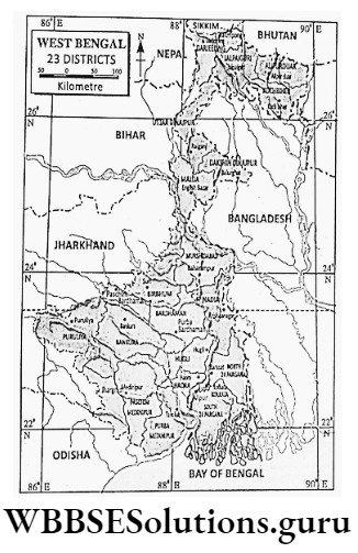
Principal Language-Bengali; Districts-23; Capital-Kolkata; Population of capital-1,40,13000 persons; Longest extension-623 km (north-south).
Read And Learn Also WBBSE Notes For Class 9 Geography and Environment
West Bengal is the most important state of the Indian Union which at present, consists of 29 states and 7 union territories. West Bengal is located in the eastern part of India.

Indian Union At A Glance:
Wbbse Class 9 Geography Chapter 8 Notes
Chapter 8 West Bengal Brief Outline Of West Bengal As A State Of India After Independence
Why Is The State Called West Bengal :
Though our state is located in the eastern part of India; it is called West Bengal because at the time of independence of India.
In 1947 that area belonged to ‘Bangladesh’ which was then divided by the British the eastern part was called ‘East Pakistan’, eventually known as Bangladesh while the western part was known as ‘West Bengal’.
In the area, West Bengal accounts for only 2-7% of India i.e. 32,87,263 sq. km. About 8% people of India i.e. 1,21,02,00,000 people live in West Bengal.
West Bengal ranks 4th position in population amongst 29 states of India. The density of the population in India is 382 persons per sq. km while in West Bengal, it is 1029 Persons per sq. km.
West Bengal is the leading producer of rice, jute and fish in our country. West Bengal ranks 2nd position in tea and potato production and 7th position in coal production in India.
Most of the jute mills of India are located in West Bengal. In the integrated iron and steel industry, engineering industry and tea industry, West Bengal also plays an important role in our country.
Kolkata, the capital of West Bengal is the largest trading centre of Eastern India and the biggest port of Eastern India. Netaji Subhas Chandra Bose international airport, the largest airport in Eastern India is located at Dum Dum near Kolkata.
The first metro rail in India was inaugurated in West Bengal. Kolkata is the headquarter of the Eastern and South-eastern railway.

Wbbse Class 9 Geography Chapter 8 Notes
Chapter 8 West Bengal Geographical Location
The geographical location of West Bengal can be identified in three ways
- With the help of latitude and longitude.
- According to the distance from the sea and
- In relation to the location of neighbouring states of India.
Location Of West Bengal According To Latitude And Longitude:
West Bengal is extending from 23°30′ north latitude in the south to 27°10′ north latitude in the north and from 85°50′ east longitude in the west to 89°53′ east longitude in the east.
Tropic of cancer i.e. 23°30′ north latitude passes through Puruliya, Bankura, Paschim Bardhaman (near Durgapur) and Nadia (near Krishnanagar) districts of the state.
Location Of West Bengal According To Boundaries:
West Bengal has land on three sides and water on one side. To the west are the states of Odisha, Jharkhand, Bihar and the neighbouring country Nepal.
To the north is the neighbouring state Sikkim and the neighbouring country Bhutan; to the east are Bangladesh and Assam. To the south is the Bay of Bengal.
Location Of West Bengal According To The Distance From The Sea:
West Bengal is bordered by the sea on its south. Hence, it is called a coastal location. North-south extent of West Bengal is about 623 km.
The east-west extension is not even. It is 320 km along the Tropic of Cancer while it is only 9 km in Uttar Dinajpur.
Chapter 8 West Bengal Neighbouring Countries And States Of West Bengal
Nepal, Bangladesh and Bhutan, the three independent neighbours are the border countries of West Bengal and five bordering states namely Bihar.
Jharkhand, Odisha, Assam and Sikkim as well as Tripura though not located along the border are very close in relation to West Bengal.
Nepal The Neighbouring Country
Nepal At A Glance :
Length of West Bengal-Nepal border about 90 km; Area of Nepal-1,40,797 sq km; Population-2,98, 001 000 persons; Density of population-211 persons per sq km; Capital-Kathmandu; Highest peak-Mt. Everest (8848 m); Longest river-Kaligandak.
Nepal is situated to the north of West Bengal along the western border of the Darjeeling district. It is a mountainous country with the highest peak Mt. Everest, the highest peak in the world. It is a sparsely populated country.
There are many valleys in Nepal, namely Kathmandu, Pokhara Valley etc. Important peaks are Makalu, Dhaulagiri, Annapurna etc. The country is occasionally forested.
Nepal is mostly dependent on agriculture. Rice is the principal crop. Other crops are jute, jowar, and millet. Fruits are apples, oranges etc. But the country lacks in industries.
Nepal is connected with West Bengal by roadways and railways, Nepal is a landlocked country. So, Nepal exports to other countries through Kolkata port.
Wbbse Class 9 Geography Chapter 8 Notes
Bhutan The Neighbouring Country
Bhutan At A Glance :
Length of West Bengal-Bhutan border-About 150 km; Area-47,000 sq km; Population-72,00,000 persons; Density of population-15 persons per sq km.
Capital- Thimpu; Population of capital-13,000 persons; Official language-Dzonka; Highest peak- Kulakangri (7554 m); Longest river-Manas; Principal resource-Cardamom, apples, oranges, lac, orchids etc.
Bhutan belongs to the Himalayas and is another independent country located on the northern border of West Bengal. According to a special treaty Bhutan has to take advice from the Government of India about its foreign affairs.
Bhutan is a small sparsely populated country. In the northern part of Bhutan is extending the Great Himalayas, in the middle part is extending the Central Himalayas and in the southern part is extending the Siwalik Himalayas.
A few famous valleys, namely Paro, Punakha and Thimpu belong to the Central Himalayas. In the northern part of Bhutan stands the Chomolari (7314 m) which is also known as the ‘Queen of the mountains’.
The southern part of Bhutan experiences frequent ‘thunder showers’ because of which Bhutan is called the ‘Land of Thunder Dragon’. In the south at the foothills of the Himalayas, there is the ‘Duars’ which is the ‘Doorway to Bhutan’.
Torsa, Raidak, Sankosh, Manas are the principal rivers of Bhutan. Dense forests of sal, oak, and sissoo are found in Bhutan. Agriculture is not well developed. Large cardamom is the most important cash crop.
Rice, wheat, and corn are also cultivated. Bhutan is industrially backwards due to a lack of minerals. Bhutan depends on Kolkata port for its trade. Food products, medicines, and machinery are collected from West Bengal.
Bangladesh The Neighbouring Country
Bangladesh At A Glance:
Length of West Bengal-Bangladesh border-About 900 km. Area-1,43,998 sq km; Population-about 17,00,00,000 persons; Density of population-1165 persons per sq km.
Capital-Dhaka; Official language-Bengali; Highest peak-Keokradang (1230 m); Longest river-Padma-Meghna, Principal resources-jute, rice, tea, leather, natural gas etc.
Bangladesh is located along the eastern border of West Bengal. On 16th December 1971 Bangladesh established itself as an independent sovereign country.
Major parts of Bangladesh belong to the Bengal Delta except for the uplands in the east and southeast. The extensive plainland is made of alluvium deposited by the rivers Padma, Meghna, Jamuna etc.
Ganga, the principal river of West Bengal flows as Padma through Bangladesh Tista, and the principal river of North Bengal also flows through Bangladesh.
Fertile alluvial tract favours cultivation in Bangladesh. Important crops are jute, rice, tea, sugarcane, cotton, tobacco, potato, oilseeds etc.
Important industries of Bangladesh are the Jute industry, tea industry, silk industry etc.
Kolkata is connected with Dhaka, the capital of Bangladesh by airways. Bangladesh is also connected with West Bengal by waterways and roadways.

Class 9 Geography And Environment Chapter 8 Solutions
Bihar The Neighbouring State
Bihar At A Glance :
Length of West Bengal-Bihar border-About 300 km; Area-94,163 km; Population- 10,38,4637 persons (2011); Density of population -1102 persons per sq km; Capital- Patna; Official language-Hindi; Principal river-Ganga.
Bihar is located on the western border of West Bengal. Ganga, the principal river of West Bengal has entered our state after flowing through Bihar.
The landform of Bihar is mostly plain. River Ganga and its tributaries are flowing through Bihar. Summers are warmer and winters are cooler than that of West Bengal.
But rainfall is less. Plenty of rice, wheat, pulses and oilseeds are produced on fertile plain land. Agro-based industries like sugar mills, and oil mills have developed.
West Bengal is connected by national highways, railways, the Ganga river and Kolkata-Patna airways with Bihar. Bihar gives oilseeds, and wheat to West Bengal and takes machinery, jute goods, and tea from West Bengal.
Chapter 8 West Bengal Jharkhand The Neighbouring State
Jharkhand At A Glance :
Length of West Bengal-Jharkhand border-About 79, 714 sq km; Population- 3,29,66,238 persons (2011); Density of population-about 414 persons per sq km; Capital- Ranchi; Official language-Hindi; Principal river-Damodar, Son etc.
Jharkhand is located on the western border of West Bengal. The state of Jharkhand was formed on 15th November 2000 comprising the mineral-rich southern part of Bihar.
The state of Jharkhand is a plateau country. The rivers, namely Damodar, Mayurakshi, and Subarnarekha have originated in Jharkhand and are flowing through West Bengal.
Due to the stony landscape, summers are too hot and winters are also severe. Trees namely sal, Palash, mahua are found in the forests which are scattered throughout the state.
Jharkhand is a mineral-rich state in India. Coal, iron ore, limestone, bauxite, mica, manganese etc. are abundant everywhere. Industries like iron and steel, cement, fertilizer, and engineering have developed.
The famous Grand Trunk Road, Eastern and South-eastern railways, and Kolkata-Ranchi airway connect West Bengal with Jharkhand.
Jharkhand gives coal, and iron to West Bengal and takes machinery, jute goods, and tea from West Bengal. Most of the import-export trade of Jharkhand is done through the Kolkata and Haldia ports of West Bengal.
Odisha The Neighbouring State
Odisha At A Glance :
Length of West Bengal-Odisha border-About 150 km; Area-1,55,782 sq km; Population-4,19,47,358 persons (2011); Density of population-269 persons per sq km; Capital-Bhubaneswar; Official language-Odia. Principal river-Mahanadi.
The state of Odisha is situated to the west of West Bengal along the border of the Purba and Paschim Medinipur districts.
The state of Odisha is a plateau country.
Moderate climate prevails in southern parts while the northern part of Odisha experiences an extreme type of climate. Forests are also scattered amidst the plateau.
Plenty of rice grows here. Jute, sugarcane, pulses and groundnut are also cultivated. Odisha is a mineral-rich state. Iron ore, coal, bauxite, limestone, graphite etc. are abundant.
Based on these minerals iron and steel, engineering as well as paper, and cement industries have developed. Bhubaneswar, the capital of Odisha and Cuttack are directly connected with Kolkata through the south-eastern railway as well as roadways and airways.
Odisha takes tea, jute goods, engineering goods, and machinery from West Bengal and gives rice, fish, minerals, machinery etc. to West Bengal.
Assam The Neighbouring State
Assam At A Glance :
Length of West Bengal-Assam border-About 90 km; Area-78,523 sq km; Population- 3,11,69,272 persons (2011); Density of population -397 persons per sq km; Capital- Dispur.; Official language-Asamiya; Principal river-Brahmaputra.
The state of Assam is situated to the northeast of West Bengal along the eastern border of Koch Bihar and Alipurduar.
The central part of Assam is occupied by the Brahmaputra valley which is bordered to the north and southeast by the mountain ranges. Excessive rainfall occurs and winters are severe.
Many parts of the state are densely forested. Assam is the leading producer of tea in India. Rice, jute, sugarcane, oranges and pineapples are produced abundantly.
Mineral oil is the most important resource of Assam. Assam is connected with West Bengal by the northeastern frontier railway and National Highway-31.
Assam is also connected with West Bengal by airways. Assam gives tea, jute, petroleum and wood to West Bengal and takes machinery, chemicals, and medicines from West Bengal.
Most of the import-export trade is carried out through the Kolkata port of West Bengal.
Sikkim The Neighbouring State
Sikkim At A Glance:
Length of West Bengal-Sikkim border-About 60 km; Area-7,96,000 sq km; Population-6,07,688 persons (2011); Density of population-86 persons per sq km.
Capital-Gangtok; Official language-Lepcha, Bhutia, Nepali; Principal river-Tista; Highest peak-Kanchenjungha (8598 m).
The state of Sikkim is situated to the northeast of West Bengal along the northern border of the Darjeeling district.
Sikkim is a mountainous state. Amidst the mountain ranges lies the Tista Valley. Rainfall is abundant, so, mountain slopes are densely forested.
Principal crops are rice, wheat, corn, large cardamom etc. Fruits like apples and oranges are common. Industries are lacking. Mainly fruit processing and cotton mills are common.
Sikkim is connected with West Bengal by National Highway-31 which runs along the river Tista.
Due to its infertile rugged terrain, Sikkim has to collect most of the items from West Bengal while West Bengal collects large cardamom, apples, and oranges from Sikkim.
Class 9 Geography And Environment Chapter 8 Solutions
Tripura The Neighbouring State
Tripura At A Glance :
Area-10,491 sq km; Population-36,71,,032 persons (2011); Density of population- 350 persons per sq km; Capital-Agartala; Official language-Bengali; Highest peak-Betling Sib (939 m); Principal river-Manu.
Tripura is located to the east of Bangladesh which is located to the east of West Bengal. Most parts of Tripura are hilly and forested.
Important agricultural crops are rice, jute, tea, rubber etc. Though the state is not developed in large-scale industries cottage industry is well developed in Tripura.
Cotton goods and cottage industrial products come from Tripura to West Bengal and from West Bengal machinery, chemicals, and medicines go to Tripura.
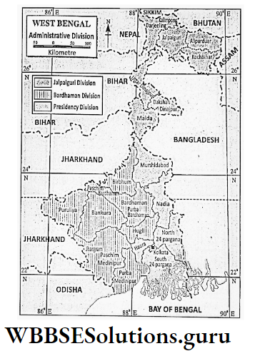
Chapter 8 West Bengal Administrative Divisions Of West Bengal
West Bengal, at present, consists of 23 districts. In West Bengal, four types of administrative structures are there-Division, District, Sub-division and Block.
Division:
23 districts of West Bengal have been grouped into five divisions. These are Bardhaman, Jalpaiguri, Presidency Malda and Medinipur divisions. Each division is administered by Divisional Commissioner.
District:
Each district of West Bengal is governed by District Collector or District Magistrate (D.M.) with exception of the Kolkata district which is administered by Kolkata Municipal Corporation (except law and order).
Sub-Division:
Each district consists of more than one sub-divisions. Example. Haora, Malda and Uttar and Dakshin Dinajpur each of these districts have two sub-divisions only. Each sub-division is governed by Sub-divisional Officer (S.D.O.)
Class 9 Geography Chapter 8 Question Answers
Administrative Divisions Of West Bengal
1. Bardhaman Division:
- Purba Bardhaman (H. Q. Bardhaman),
- Paschim Bardhaman (H. Q. Asansol),
- Hugli (H. Q. Chinchura),
- Birbhum (H. Q. Suri).
2. Presidency Division:
- Haora (H. Q. Haora),
- Kolkata (H. Q. Kolkata),
- Nadia (H. Q. Krishnanagar),
- 24 Parganas (N) (H. Q. Barasat),
- 24 Parganas (S) (H. Q. Alipur).
3. Jalpaiguri Division:
- Alipurduar (H. Q. Alipurduar),
- Koch Bihar (H. Q. Koch Bihar),
- Darjeeling (H. Q. Darjeeling),
- Jalpaiguri (H. Q. Jalpaiguri),
- Kalimpong (H. Q. Kalimpong).
4. Malda Division:
- Malda (H. Q. English Bazar),
- Uttar Dinajpur (H. Q. Raigunj),
- Dakshin Dinajpur (H. Q. Balurghat),
- Murshidabad (H. Q. Baharampur).
5.Medinipur Division:
- Purba Medinipur (H. Q. Tamluk),
- Paschim Medinipur (H. Q. Medinipur),
- Jhargram ( H. Q. Jhargram),
- Puruliya (H. Q. Puruliya,
- Bankura (H. Q. Bankura).
Chapter 8 West Bengal Community Development Block
Each sub-division consists of a number of C.D. Blocks. These are administered by Block Development Officer or B.D.O. Each Block consists of a few Gram Panchayats.
Panchayat Raj Or Village Council:
In West Bengal Panchayat Act was enacted in 1973. This is a three-tier administrative system. At its lowest level is Gram Panchayat which consists of a number of grams.
It is governed by Panchayat Pradhan. A few Gram Panchayat form Panchayat Samiti which is ruled by Sabhadhipati. Each block consists of one Panchayat Samiti.
At the top level is Zilla Parishad which consists of all the Panchayat Samities of the district. It is headed by the Zilla Sabhadhipati.
Gorkha Hill Council :
It was formed in 1988 and it consists of three sub-divisions (out of four) Darjeeling, Kalimpong and Kurseong. It administers all departments except a few like law and order, revenue etc.
Siliguri sub-division is administered by Mahakuma Parishad instead of Zilla Parishad.
Chapter 8 West Bengal Physical Environment
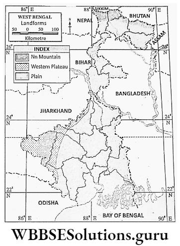
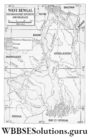
Physiography And Drainage Of West Bengal
The landform of West Bengal is very much diversified. Lofty mountain peaks, rolling uplands, and extensive fertile plains are the main physiographic characteristics of West Bengal.
Depending on such variation in landform, rivers of West Bengal flow either southward or southeastward.
Physiographically, West Bengal can be divided into three divisions
- Northern mountains,
- Western plateau and
- The Plains.
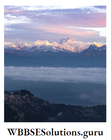
Northern Mountains
Location:
Northern Mountain consists of three sub-divisions of Darjeeling and Kalimpong district (Darjeeling town, Kalimpong and Kurseong sub-divisions) and Kumargram and Kalchini P.S. of Alipurduar district.
Relief:
Relief of this region is very much ruled due to the presence of lofty mountains intervened with deep gorges.
The river Tista is flowing from the north to the south and has divided the region into two parts-western and eastern parts of the Tista valley.
To the western part of the Tista Valley, Singalila and Darjeeling ranges stand in a north-south direction. Singalila stands along the border of Darjeeling district and Nepal.
There are a few lofty peaks in this range such as Sandakphu (3630 m), Phalut (3596 m), and Sabargram (3543 m). Sandakphu is the highest peak in this region as well as in West Bengal.
Class 9 Geography Chapter 8 Wbbse Solutions
The Darjeeling range rises steeply from the Terai region in the south. To the south of it stands Tiger Hill (2573 m). Further south stands Daw Hill and to the east is Takdah Peshak Hill.
An important peak of this area is Sinchal (2615 m). The Darjeeling range is also known as the Ghoom range.

The height of the eastern part of the Tista Valley is much less. Rishila (3121 m), the highest peak of this region is situated near Kalimpong town.
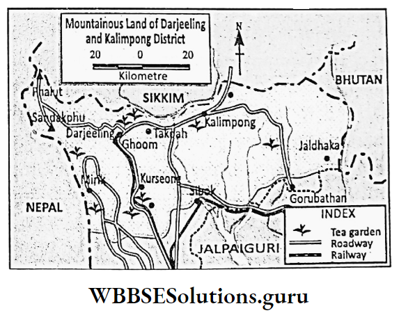
Kumargram and Kalchini P.S. of Alipurduar district are also mountainous but of low relief.
Renigango (1885 m) and Little Sinchula (1726 m) are two important peaks. There is a pass called Bauxa Duar which leads to Bhutan.
Rivers:
Many rivers are flowing through the mountainous region of West Bengal. These rivers are snow-fed and have water throughout the year.
They are very much turbulent and are favourable for hydel power generation. Important rivers of this region are Tista, Jaldhaka, Mahananda, Torsa, Kaljani and Balason.
The principal river of this region is Tista which rises in the Zemu glacier then flows through this region and finally joins the river Jamuna (Brahmaputra) in Bangladesh.
Class 9 Geography Chapter 8 Wbbse Solutions
River Tista has many tributaries, namely the Rangeet, Riang, the right bank tributaries and Rangpo, Reeling the left bank tributaries. Tista is very much turbulent and often floods the region.
So, it is known as the ‘River of Horror’. Another important river in this region is Jaldhaka. There is a river project on the Jaldhaka River.

Chapter 8 West Bengal Western Mountains
Location:
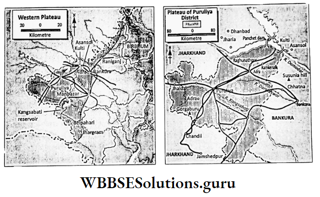
The landform of the entire Puruliya district’ and its adjacent Jhargram, Bankura, Paschim Bardhaman and the western part of Birbhum district is undulating or rolling.
This undulating upland of the western part of West Bengal is called Western Plateau.
Relief:
Geologically western plateau is part of the Chotanagpur plateau of Jharkhand. This is the most ancient landmass of West Bengal and is made of ancient igneous and metamorphic rocks with an undulating surface.
To the west, the land is higher (maximum 677 m) and to the east, it is lower (lowest 75 m). So, the plateau slopes from the west to the east.
There are small hills made of hard rocks, such as Ayodhya Hill and Baghmundi Hill in Ayodhya Hill the western part of the Puruliya district.
Gorgaburu of Ayodhya Hill is the highest peak (677 m) in this region. To the north of this district is Panchet Hill (643 m) and to the south is located Bhandari Hill.
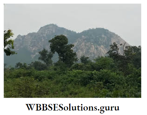
The eastern part of this plateau slopes gradually and is extended in the western part of Paschim Medinipur, Bankura, Paschim Bardhaman and Birbhum districts.
Small hills of hard rocks are also in this area, such as Belpahari of Paschim Medinipur, Mathurkhali of Birbhum and Biharinath (435 m) and Susunia (440 m) of Bankura district.
Rivers:
Damodar is the principal river of the plateau region. After originating in the Khamarpat hill, the river Damodar is flowing through this region and finally joins the Hugli River.
Mundeswari, the distributor of Damodar joins the river Rupnarayan. Kansai or Kangsabati, another important river originates in the north of Ayodhya hill in the Puruliya district flows south-eastward and finally joins the river Hugli.
A reservoir has been made at the confluence of the river Kangsabati and Kumari, a tributary to Kangsabati near Mukutmanipur for irrigation and to control floods.
Class 9 Geography Chapter 8 Wbbse Solutions
River Darakeswar and Silai or Silabati have joined each other near Ghatal in Paschim Medinipur. Rupnarayan, the confluent of these two rivers joins the river Hugli near Geokhali.
Other important rivers are Mayurakshi, Ajoy, Dwaraka, Brahmani, Bakreswar, Kopai, Subarnarekha etc.
Chapter 8 West Bengal The Plains
Location:
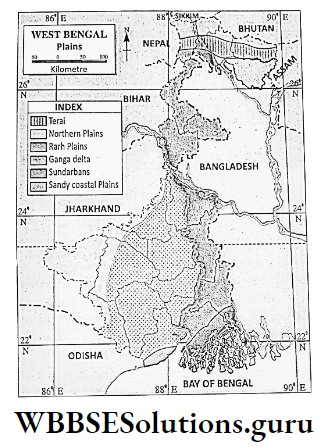
Except for the northern mountains and the western plateau, the rest of West Bengal is under the plain region. The Plains of West Bengal can be divided into three regions
- Plains of North Bengal,
- Rarh Plain and
- The Ganga Delta Plain.
Plains Of North Bengal
The plains of North Bengal include the plains of Malda, Uttar and Dakshin Dinajpur, Koch Bihar, Jalpaiguri and Darjeeling.
The region is again subdivided into Terai or Duars Plain and Ganga-Brahmaputra Plain.
1.Terai Or Duars Plain:
Southern parts of the Alipurduar district and most parts of the Jalpaiguri district and the Siliguri sub-division of the Darjeeling district belong to the Terai or Duars plain.
The mountainous land of Darjeeling Himalaya suddenly slopes into this plain which slopes from the north (200 m) to the south (75 m) and is made of stones and pebbles brought by the swift-flowing Himalayan rivers.
The plan is forested due to heavy rainfall and the ground is humid and damp. So, the plain is called ‘Terai’ a French word which means ‘damp’. It is actually, the entrance to Bhutan.
So, Terai is also known as ‘Duars’ which means ‘doors’. Tista, Torsa, Jaldhaka, and Raidak are the important rivers of the Terai Plain.
Following the slope of the land, these rivers are flowing from the north to the south and deposit sands, stones and pebbles as they suddenly drop from the mountains into the plains.
In some places rivers are braided. In the rainy season, they occasionally flood the region and often change their courses.
2.Ganga-Brahmaputra Doab:
The land between the river Ganga and Brahmaputra is called Ganga-Brahmaputra Doab. It slopes from the north (about 75 m) to the south (about 30 m).
Based on the physiographic variation this is again divided into three sub-divisions-Tal, Barind or Barendrabhumi and Diara.
3. Tal:
Some parts of southern Jalpaiguri, most parts of Koch Bihar districts and the lowland between the river Kalindi and Mahananda of Malda district are known as Tal.
Rivers of this region often change their courses and are responsible for the occasional flood. Therefore, bills and marshes are common.
4..Barind Or Barendrabhumi:
The eastern part of Dakshin Dinajpur and the eastern part of Maida districts are uneven and made of red old alluvium. This is known as Barind or Barendrabhuml.
5. Diara:
The land close to the river Ganga in the southwestern part of the Maida district is made of new alluvium and is fertile and densely populated. This is known as Diara.
Tista and Mahananda are two principal rivers of Ganga-Brahmaputra Doab region. The slope of the land is gentle, so, the rivers are flowing sluggishly in a meandering course.
Class 9 Geography And Environment Notes Wbbse
In the north important rivers are Kaljani, Raidak, and Dharall while in the south important rivers are Kalindi, Punarbhaba, Tangon, Nagar, and Atrai. The river Ganga is flowing through the southern part of the region.
Rarh Plain
The flat land in between the Bhagirathi-Hugli River in the east and the plateau in the west is known as the Rarh Plain. The region also includes the plains of Purba and Paschim Medinipur, Bankura and Bardhaman.
Rarh Plain is made of silts and alluvium deposited by the rivers which flow from the west (75 m) to the east (10 m) following the slope of the land. In the east floods are common and consequently, many lowlands have formed.
Rivers like Damodar, Mayurakshi, Ajoy, Rupnarayan and Kangsabati are flowing through the Rarh region and finally join the Bhagirathi- Hugli as tributaries.
These rivers are rainfed as they have originated in the plateau of the west. So, they become dry except in the rainy season. They flood often in the rainy season as their beds are shallow.
The Ganga-Delta Plain
The Ganga Delta comprises the districts of Murshidabad, Nadia, Kolkata, North and South 24 Parganas. The delta is formed by the deposition of silts of the river Ganga and its tributaries.
The plan is divided into four sub-divisions-Old or Moribund Delta, Mature Delta, Active Delta and Sandy coastal plain of Purba Medinipur district.
The plain slopes from the north to the south in a gentle slope with an average height of 15 m above sea level.

Moribund Delta comprises the northern part of 24 Paraganas (N), Nadia and the eastern part of Murshidabad districts.
The distributaries of Padma or Bhagirathi, namely Bhairab, Jalangi, Churni, and Mathabhanga cannot deposit silts any more. So, the process of delta formation.
Class 9 Geography And Environment Notes Wbbse
was stopped long ago and many abandoned river channels and bills have been left out. So, the region is a land of dead and decaying rivers and is locally called ‘Bagri’.
The mature delta comprises the north and central parts of 24 Parganas (S), the central part of 24 Parganas (N) and the Kolkata districts.
A few rivers like the Ichhamati are still depositing a little number of silts thereby changing the landforms of the region. Many bills and marshy lands are common in this region. Example. Salt Lake to the east of Kolkata.
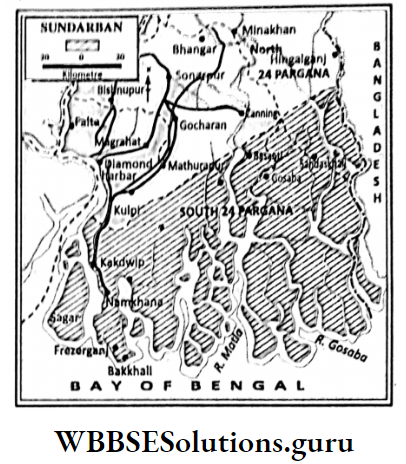
Active delta comprises southern parts of 24 Parganas (S) where delta formation is going on actively. So, new landmasses are developing, for Example. Purbasha or New Moore Island which is located to the south of Sundarban.
The slope of the land is very low, only 5 m above sea level. So, the saline Nurpur water of the Bay of Bengal enters easily through the rivers and the soil of this region becomes saline.
Class 9 Geography And Environment Notes Wbbse
Many islands are found Example. Sagar Island (largest), Kakdwip, Dalhousie, Lothian, Frezerganj, Baluchari etc.
The sandy coastal plain is the coastal strip along the Bay of Bengal of Purba Medinipur. It is flat but sandy, scattered with sand dunes.
In front of the Digha sand dune lies the sea beach of Digha. The land slopes from the north to the south.

The river Bhagirathi-Hugli is flowing along the western margin of the delta region. In the eastern part, important rivers are Bhairab, Jalangi, Mathabhanga, Ichhamati, Churni and Saraswati.
These rivers are flowing from the north to the south following the slope of the land. Bhairab, Jalangi and Mathabhanga have branched out from the river Padma.
Jalangi and Mathabhanga have joined the river, Bhagirathi. The southern part of Mathabhanga is known as Churni. The river Ichhamati has branched out from Mathabhanga and drains into the Bay of Bengal.
Once the Saraswati was the main flow of Bhagirathi but now it is a dead river. In the Sundarban region, many rivers have branched into innumerable river channels like Matla, Gosaba, Vidyadhari, Piyali, Raimangal, Kalindi, and Bartala.
These rivers are tide-fed and they have wide estuaries through which saline water of the Bay of Bengal enters far into the rivers of the Sundarban region.
The rivers of the Sandy coastal plain of Purba Medinipur are small and drain into the Bay of Bengal following the slope of the land, for Example.Rasulpur, Pichhabani. Rasulpur is the principal river of this region.
Chapter 8 West Bengal Brief Overview Of Water Resources Of West Bengal
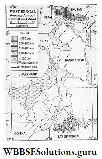
There is no alternative to water, the ‘Blue gold’ resource in which our planet Earth is rich, but scarce in fresh water. The source of this water is rainwater in which West Bengal is rich (about 175 cm annual rainfall).
Distribution Of Rainfall
Northern districts of West Bengal namely Darjeeling, Kalimpong, Jalpaiguri, Alipurduar, Koch Bihar and Uttar Dinajpur receive maximum yearly rainfall, of about 250 cm or more.
While Bankura, Birbhum, Puruliya, Jhargram, Paschim Medinipur, Nadia, and 24 Murshidabad districts receive annually 170 cm or less. Most of the rain (70 to 80%) in West Bengal occurs from June to September.

Volume Of Rain Water
The volume of rainwater in West Bengal, if estimated will be nearly 165.56 cubic km. It is maximum in Jalpaiguri district (including Alipurduar district) about 19.15 cubic km.
It is 17.14 cubic km in 24 Parganas (S), 15-41 cubic km in Paschim Medinipur (including Jhargram), 11.23 cubic km in Bardhaman (Purba and Paschim) and 11-10 cubic km in Koch Bihar.
While it is not enough in Kolkata (0-31 cubic km), Haora (2.4-8 cubic km) Dakshin Dinajpur (4.12 cubic km), and Hugli (5.19 cubic km).
Inland Water Resource
Some of the rainwater goes underground, a little is evaporated while much of it flows as surface runoff. Inland water comprises both groundwater and surface water.
By volume, the inland water resource of West Bengal is about 129 cubic km. It is higher in Jalpaiguri including Alipurduar (16-85 cubic km), 24 Parganas (S) (11-78 cubic km), Paschim Medinipur (11.38 cubic km), Koch Bihar (9.94 cubic km).
But it is scarce in Kolkata (0.25 cubic km), Haora (2.0 cubic km), Dakshin Dinajpur (3.40 cubic km), Hugli (4.10 cubic km), and Nadia (4.83 cubic km).
The water reserves of West Bengal are only 6 cubic km. It is 4 cubic km in Ponds and bills while less than 2 cubic km in reservoirs.
Potential water per capita is decreasing. It was 5200 cubic km (yearly) in 1951, 2941 cubic km in 1971, 1870 cubic km in 1991 and 1411 cubic km in 2011.
Wbbse Class 9 Geography Chapter 8 Notes
In the previous decade’s rapid population growth, the increasing rate of using irrigation water, and global warming led to uncertainty.
Rainfall is responsible for such a reduction in the amount of per capita water resources which may cause various problems in future.
Chapter 8 West Bengal Merits And Demerits Of Multiple Use And Overuse Of Water From River Canal Tank Well Ground Water
We use mainly two types of water-surface water from ponds, bills, rivers etc. and underground water which is obtained from wells and tube wells.
Water is used mainly in three sectors-agriculture, industry and household purposes. In developed countries, water is mainly used in industries while in developing countries like India water is mainly used in agriculture.
In West Bengal, large quantities of underground water are used by wells and tube wells in agriculture for irrigation. As a result, the underground water level has been lowered and consequently, rivers, canals, ponds and bills are drying up.
Different types of salts mixed with underground water also increase the salinity of farmlands. In many parts of West Bengal, arsenic is also mixed with underground water and causes various types of diseases when used as drinking water.
Water is also polluted by household wastes, agricultural runoff from chemical and pesticide-treated fields, and runoff from domestic wastewater and sewage and waste products of industries.
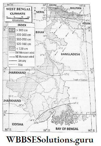
Climate Of West Bengal
The climate of West Bengal is warm and humid. Rainfall occurs in summer while winters are dry and mild. This type of climate is known as Tropical Monsoon Climate.
Climate Characteristics Of West Bengal:
The change of seasons is the most important feature of the climate of West Bengal. Four seasons, namely summer, rain, autumn and winter rotate in a cycle in the climate of West Bengal.
In summer moist south-west monsoon wind gives rain in West Bengal. In winter dry and cold north-east monsoon wind keeps the climate of West Bengal cool and dry.
In summer wind blows from the southwest direction while in winter wind blows in opposite direction.
In the mountainous region of North Bengal, summers are pleasant because of their altitude, but winters are severely cold. The rest of West Bengal experiences mild weather.
Chapter 8 West Bengal Seasons Of West Bengal
Based on variation temperature, arrival and departure of monsoon wind and the amount of rainfall the meteorological department of the Government of India has divided the climate of West Bengal into four seasons-summer, rainy season, autumn and winter.
Summer (March To May)
In March the sun crosses the equator and moves apparently towards the Tropic of Cancer. So, temperature increases in West Bengal. In April and May temperature rises from 35°C to 42°C.
WBBSE Class 9 Geography Environment Chapter 8 summary
In the plateau region in the west, the temperature reaches 44°/45°C when hot wind called ‘Loo’ blows over the plateau. But, the temperature in Darjeeling mountain remains as low as 16°C on average because of the altitude.
Often, in the evening thunder clouds from the north-west give rain along with hailstorms. This is called Nor’wester or Kalbaisakhi (Calamity of the Bengali month ‘Baisakh’).
Rainy Season (June To September)
By the second week of June, moist south-west monsoon wind enters West Bengal and gives plenty of rain. In this season maximum rainfall (275-300 cm) occurs in the Northern mountainous region.
Moderate rainfall takes place on the plains and scanty rainfall occurs on the plateau. But the average annual rainfall in West Bengal is 175 cm 80% of annual rainfall in West Bengal occurs in the rainy season.
Autumn (October To November)
By the end of September, the sun crosses the equator and moves towards the Tropic of Capricorn. South-west monsoon wind moves back and rainfall starts to decrease. This is known as the season of Retreating Monsoon.
Slowly the north-east monsoon wind starts to arrive in West Bengal and gives an indication of winter. Often cyclonic rainfall occurs which is locally known as ‘Aswiner Jhar’.
Winter (December To February)
In December the sun is at the zenith of the Tropic of Capricorn. West Bengal receives oblique sun rays, so, the temperature starts to decrease.
Cold and dry north-east monsoon wind also starts to blow over West Bengal. In January, the temperature becomes very low. The mountainous region of Darjeeling district becomes severely cold and the temperature drops to 4°C.
Occasionally snowfall occurs. Over the plateau, the temperature is 10°C and on the plains, it is 16°C only. Winter is dry as this wind does not capture any moisture.
This stable weather condition is disturbed only when the cyclonic storm from the west sets in. This storm is called ‘Western Disturbance’.
Chapter 8 West Bengal Impact Of Monsoon On The Climate Of West Bengal
The word ‘monsoon’ has been coined from the Arabian word ‘Mausim’ means ‘seasons’. So the wind which blows according to the seasons is called monsoon wind.
Monsoon wind plays a great role in the climate of West Bengal. In summer when a moist southwest monsoon crossing the Bay of Bengal blows in West Bengal gives heavy rainfall.
About 70 to 80% of rain occurs during this time. Again, in winter, the cold and dry northeast monsoon wind of land origin keeps the climate of West Bengal dry and cool.
WBBSE Class 9 Geography Environment Chapter 8 summary
Cold and dry north-east monsoon wind from Siberia and Tibet blows over West Bengal in winter when the temperature becomes very low. The wind does not give any rain as it is dry.
So winters are dry in West Bengal. Based on the arrival and departure of the southwest and northeast monsoon wind the climate of West Bengal is divided into four seasons-Pre-monsoon or Summer.
Monsoon or Rainy, Retreating monsoon or Autumn and Post monsoon or Winter season.
Chapter 8 West Bengal Impact Of Change Of Seasons On Human Life
The change of seasons is an important feature of climate. There is a great impact of the change of seasons in human life.
Food habits are greatly influenced, for Example. vegetables like ladies’ fingers, mango, berry, jack fruit, leeching etc. grow in summer while cabbage, cauliflower, carrot, beet, spinach, and oranges grow in winter.
Therefore, our food habits also change according to the seasonal crops and fruits. Dresses In summer we wear light cloth while in winter we wear coarse and woollen garments.
Human skill-We get tired in summer while in winter we are energetic. Specialisation in livelihood In rainy season agriculture, pisciculture is well practised.
In autumn and in winter activities based on festivals and tourism become predominant. In winter harvesting of the Kharif crop and sowing of the Ravi crop; fairs, circuses and other entertainment-related jobs and activities become important.
Chapter 8 West Bengal Soil And Natural Vegetation Of West Bengal
Soil
The upper part of the earth’s crust that is made of fine loose materials where trees can grow is called soil. In West Bengal, three types of soils are found-alluvial soil, laterite soil and saline soil.
1. Alluvial :
Alluvial soil is formed by the deposition of sand, silt and clay brought by the rivers. It is found in the vast plain of West Bengal. Alluvial soil is of two types-old alluvium and new alluvium.

2. Old Alluvium :
Old Alluvial is found in Koch Bihar, Dakshin Dinajpur and in parts of Malda. It is reddish in colour and is known as red soil. Rice, mulberry and mango grow well in this soil.

3. New Alluvium:
New alluvium is found in the plains of North and South 24 Parganas, Uttar Dinajpur, Haora, Hugli, Purba Bardhaman and Nadia. The colour of the soil is grey and the soil is very much fertile. Rice, wheat, sugarcane and jute grow well.
4. Laterite Soil:
Laterite soil is found in Puruliya, Birbhum, Bankura, Murshidabad, Jhargram, Paschim Medinipur and Paschim Bardhaman districts. The word ‘Laterite’ is coined from the Latin word ‘Later’ means ‘brick’.
The iron content of the soil is high. So the soil is red in colour and is stony. Therefore it is infertile and cultivation is practised only with irrigation and the application of fertilizer.
5. Saline Soil:
Saline soil is found in North and South 24 Parganas. The soil of the Contai coast is also saline.
The soil of Sundarban is saline as the region is often flooded with seawater during high tides. Cultivation is not possible in this type of soil.
6. Mountain Soil:
Mountain soil is found in the Northern Mountains region. This soil is stony and acidic. In some places, oranges, cinchona, and apples grow.
Natural Vegetation
Trees and plants that grow naturally are together known as Natural vegetation. When it grows over a wide area is called a forest.
If only grasses grow over a wide area, it is called Grassland. In West Bengal, four types of natural vegetation are found.
1. Tropical Mixed Forest Of Mountainous Region:
In the Northern mountainous region, a mixed forest of Tropical deciduous and Tropical evergreen trees is found. Evergreen trees, namely sissoo, chapatis, gurjan and deciduous trees like oak, maple, laurel etc.
are common in this forest at an altitude of 2500 m. Above it are found coniferous trees like pine, deodar etc.
2. Tropical Humid Deciduous Forest Of Plains:
Most of the trees have been cut to make room for cultivation and settlements in the plain. Mango, banyan trees, and jackfruit are common in the plains. In terai plains sal, toon etc. grow.
WBBSE Class 9 Geography Environment Chapter 8 summary
3. Mangrove Vegetation Of Delta Or Sundarban:
On the saline soil of the Sundarban region Sundari, Goran, Geona, hentai, hola, and Kolkata are grown. They have breathing roots rising above the soil.
They also have stilt roots to protect them from storms, waves etc. This type of natural vegetation is called Mangrove vegetation.
Mangrove Vegetation Of Delta Or Sundarban:
On the saline soil of the Sundarban region Sundari, Goran, Geona, hentai, hola, and Kolkata are grown. They have breathing roots rising
above the soil.
They also have stilt roots to protect them from storms, waves etc. This type of natural vegetation is called Mangrove vegetation.
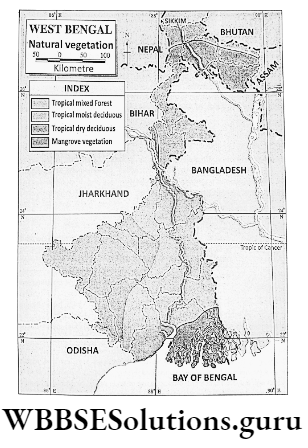
4. Dry Deciduous Forest Of The Plateau:
Deciduous trees like sal, Palash, and mahua grow abundantly on the plateau. In winter these trees shed their leaves to check the loss of water through transpiration.
It is found in the districts of Puruliya, Birbhum, Bankura, Murshidabad, Jhargram, Paschim Medinipur and Paschim Bardhaman.
Major Economic Activities
The economic activities and livelihood of the people of West Bengal depend largely on the geographical environment of the state. Since independence, West Bengal has developed various types of economic activities.
Agriculture, the industry even tourism and information technology have great importance in the economic activities of West Bengal.
Chapter 8 West Bengal Agriculture Of West Bengal Major Crops (Paddy Jute Tea)
West Bengal is principally an agricultural country. About 70% of people are engaged either directly or indirectly, in agriculture.
About one-third of the annual income of the state is contributed by agricultural activities. About 65% of the land of West Bengal is devoted to agriculture.
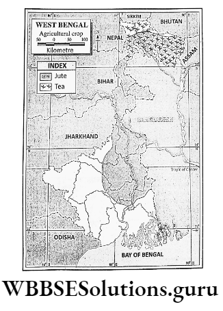
In Indian agriculture, West Bengal plays an important role. West Bengal accounts for nearly 15% of rice production, 74% of jute production and 23% of tea production in India.
Plenty of crops like potato, oilseeds, tobacco, wheat, corn, barley, betel leaf etc. also grow in West Bengal.
West Bengal is the leading producer of rice and jute in India. The state holds 2nd position in tea and potato production in India.
Though agriculture is the mainstay of the economy of West Bengal, yet West Bengal has to face problems in the agricultural sector.
Example. farmlands are mainly cultivated by traditional methods, the yield rate is low, about 50% of the agricultural fields have irrigation facilities, and small holdings in which modern.
implements are not applicable, want of store room, H.Y.V seeds, fertilizer etc. lack of adequate capital as the farmers are poor as well as they do not get proper remuneration.
WBBSE Class 9 Geography Environment Chapter 8 summary
Various measures have been undertaken to solve the difficulties faced by the agricultural sector in West Bengal by increasing the area of farmlands through the recovery of fallow land, marshy land, saline land etc.
Increasing multiple cropped land through irrigation; increasing use of fertilizer, pesticides and modern implements; increasing use of H.Y.V. seeds; emphasizing agricultural research; monetary help to small and marginal farmers etc.
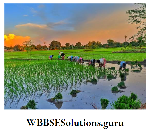
Chapter 8 West Bengal Paddy
Paddy is the principal food crop as well as the principal agricultural crop of West Bengal. About 95% farmland of West Bengal is devoted to rice cultivation.
Rice also accounts for nearly 91% of the annual production of food crops in West Bengal.
1. Multiple Use Of Paddy:
Rice is obtained from paddy. Rice is used in various types of foods, such as boiled rice, puffed rice, flaked rice etc. Starch obtained from boiled rice is used in the textile industry.
Wine is also produced from boiled rice. Paddy husks are used as a fodder crop. Paddy straw is used to shed mud houses. The rope is also made from paddy straw. Rice husk obtained from paddy is used to produce rice oil and fuel oil.
WBBSE Class 9 Environment Chapter 8 Important Points
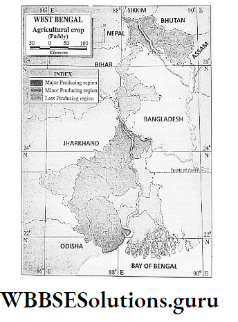
2. Producing Areas:
In West Bengal paddy is cultivated mostly everywhere. But it predominates in the districts of Purba Medinipur, Purba and Paschim Bardhaman, 24 Parganas (N).
24 Parganas (S), Nadia, Uttar Dinajpur, Dakshin Dinajpur, Murshidabad, Birbhum, Bankura etc. Purba and Paschim Bardhaman is the leading producer of paddy in West Bengal.

3. Production:
2013-14 about 15-2 million tons of paddy was produced in about 5-4 million hectares of land. West Bengal is the leading producer of paddy in India.
In West Bengal yield rate of paddy’ is 2690 kg per hectare. In West Bengal, Birbhum is the leading district followed by Bardhaman and Malda in yield rate of paddy in West Bengal.
4. Ideal Environment For Paddy Cultivation :
In West Bengal, there is extensive plain land which is ideal for cultivation. This plain is fertile and rich in alluvium.
Most parts of West Bengal receive 150-200 cm annual rainfall which is ideal for paddy cultivation. The average temperature of West Bengal varies between 22°C and 30°C which is also adequate for paddy. cultivation.
Necessary fertilizer, H.Y.V. seeds, pesticides, agricultural machinery for modern. the technique of paddy cultivation is easily available in West Bengal.
West Bengal being a densely populated state, provides cheap and skilled agricultural labour.
Chapter 8 West Bengal Jute
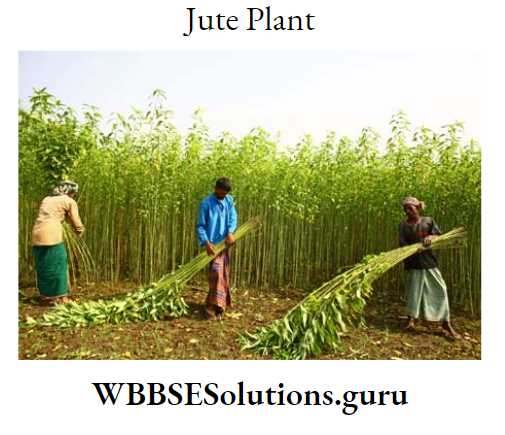
Jute is the principal fibre crop of West Bengal. It is bast fibre crop.
WBBSE Class 9 Environment Chapter 8 Important Points
1. Importance Of Jute:
Jute cultivation plays an important role in the economy of West Bengal. About 4 million people of West Bengal are engaged directly or indirectly in jute cultivation.
Millions of people in West Bengal are also linked to the production of jute goods. Every year exporting jute and jute goods large. quantities of foreign money are earned.
2. Multiple Use Of Jute:
Jute fibre Multiple uses of Jut is used in making cloth, bags, rope, carpet, tarpaulin etc. Jute stalk (stem) is used as fuel in making paper as well as in the plantation of betel leaf.
3. Types Of Jute:
There are two types of jute-White jute and Tossa jute. White jute grows well on all types of land. Tossa jute or golden jute grows on high land mainly.
4. Ideal Environment For Jute Cultivation :
In West Bengal, jute is cultivated as a Kharif crop in summer. In summer, West Bengal receives 100-120 cm rainfall on average and experiences 25°C temperature on average which is ideal for jute cultivation.
Jute cultivation prefers riverine flat plain land which is available in most parts of West Bengal. Water storage is essential for the retting of jute fibre after harvesting.
In the rainy season, a number of bills, marshes and ponds become filled with water in West Bengal. Densely populated West Bengal also provide plenty of cheap and skilled labourer for jute cultivation.
5. Producing Areas:
Plenty of jute is cultivated in almost all the districts of West Bengal, namely North and South 24 Parganas, Hugli, Nadia, Purba Medinipur, Purba Bardhaman, Malda, Uttar and Dakshin Dinajpur, Jalpaiguri including Alipurduar and Koch Bihar.
6. Production:
West Bengal is the leading producer of jute in India. In 2013-2014 about 1.5 million tons of jute were produced in about 6 lakh hectares of land and it accounts for nearly 74% of jute production in India.
Jute is the principal cash crop of West Bengal. But due to economic recession in a few previous decades, jute production has declined.
Chapter 8 West Bengal Tea
Tea is the principal cash crop of West Bengal. It is used as a mild stimulator and as a cheap beverage. It is also a plantation crop and is produced in tea estates or gardens.
1. Importance Of Tea Plant:
Tea plays an important role in the economy of West Bengal as many people are engaged directly or indirectly in tea plantations as well as by exporting tea large amount of foreign money is also earned.
2. Ideal Geographical Environment For Tea Plantation:
The tea plant is an evergreen tree. It grows well at the foothills of a mountain or along a sloping river valley of a monsoon climatic region.
Most parts of North Bengal receives 150-250 cms. of average rainfall and an average summer temperature of 27°C which are ideal climatic conditions for tea plantation.
WBBSE Class 9 Environment Chapter 8 Important Points
Tea plantation requires a hill slope which is ideal for their growth therefore, the hills of North Bengal are ideal for tea plantation.
The soil of the hills is also loamy with iron which is also ideal for tea cultivation. Women and children are engaged in the plucking of two leaves with a bud.

3. Producing Areas:
Innumerable tea gardens have developed on the hills of Darjeeling and Kalimpong districts and on the sloping Terai and Duars of Alipurduar, Jalpaiguri and Koch Bihar districts.
Tea plantations started in 1870-1875 by the British people in the Duars region of Jalpaiguri district. Recently, tea gardens have developed in Uttar Dinajpur and on the Ayodhya hill of Puruliya district.
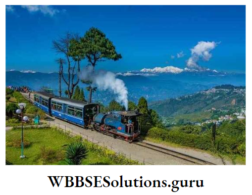
Best quality flavoured tea is produced on the hills of the Darjeeling district.

4. Production:
West Bengal ranks 2nd position in tea production in India. About 50% country’s tea is produced in Assam. In 2013-14 about 2-40 lakh tons of tea was produced in West Bengal and it was contributed by Darjeeling (5% ), Terai (33%) and Duars (62%).
Tea plantation in West Bengal is facing problems like
- old tea estates which reduce the quality as well as quantity of production,
- and scarcity in packing boxes. The development of new tea gardens and the manufacturing of packing boxes are essential to solving the problems of tea plantations.
Chapter 8 West Bengal Industries (Iron And Steel Jute Cotton Tea Food Processing Tourism Information Technology) Of West Bengal Causes Of Development Problems And Prospects
Before the independence of India the erstwhile undivided ‘Bengal’ was the leading state in industries in India.
After the independence of India, a few large-scale industries including the iron and steel industry have developed different five years plans in West Bengal.
Recently, industries like food processing, tourism, and information technology (I.T.) have also developed in West Bengal.
Iron And Steel Industry
1. Importance:
West Bengal plays an important role in the iron and steel industry in India. There are two large-scale integrated iron and steel plants-one at Durgapur and the other at Kulti-Burnpur.
One large-scale alloy steel plant has developed at Durgapur. Durgapur Steel Plant (D.S.P.) was set up at Durgapur during 2nd five-year plan.
The steel industry at Kulti-Burnpur (ISCO) was set up in 1918 and was undertaken by the Government of India in 1974. The alloy steel plant (A.S.P.) was set up at Durgapur after the independence of India during a Five-year plan.
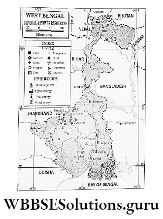
Causes of development of these three iron and steel factories in West Bengal are: Local coal resource-Good quality coal is available from Ranigunj, Andal, Dishergarh and nearby Jharia coalfield.
Nearness to the iron ore producing region- Iron ore mines of Gua, Noamundi of Jharkhand and Gurumahisani and Badampahar of Odisha are located within 350 km distance.
Availability of limestone and manganese-Limestone of Birmitrapur of Odisha and manganese from Gangpur of Odisha are in close proximity.
Availability of water-Water is easily available from the nearby Damodar River. Good communication between the port and market-The region is connected with the port and market of the Hugli industrial region through the eastern railway, G.T.
road and the navigable canals of the D.V.C. Project. Abundant cheap labour-Labour is available from the overpopulated Jharkhand state.
Supply of electricity- Power is supplied from Durgapur and another thermal power project of D.V.C.
A number of mini steel plants and sponge iron factories have also developed in many parts of West Bengal, particularly, in the districts of Puruliya, Paschim Bardhaman, Paschim Medinipur, Haora etc.

2. Problems Of The Iron And Steel Industry:
The iron and steel industry in West Bengal is facing a few problems like iron which is not locally available in the state; good quality coking coal is not available in the state.
limestone and dolomites are collected from Odisha, Jharkhand which incurs transport costs; lack of skilled labour; old and obsolete machinery; traditional. production technique; high production cost etc.
3. Prospects Of The Iron And Steel Industry:
There is a rapid increase in demand for a steel with the improvement of the construction of automobiles and various engineering industries.
So the prospect of this industry is much bright provided better quality steel is produced at a cheaper rate utilising modern machinery and modern techniques in future.
WBBSE Class 9 Geography Environment Chapter 8 summary
Chapter 8 West Bengal Jute Industry
The first jute mill in our country was set up in 1859 at Rishra near Kolkata as a joint venture by George Auckland and Biswambhar Sen, a Bengali businessman.
Within a few years, a number of jute mills were set up in West Bengal. At present, there are 76 jute mills in India. Amongst these, 59 mills are located in West Bengal.
These mills are located along the two banks of the river Hugli between Kalyani-Bansberia in the north to Baj-Baj- Uluberia in the south.

Causes Of Development Of The Jute Industry
Factors of tremendous concentration i.e. centralisation of jute mills along the Hugli River are
- Availability of local raw jute;
- Close proximity to Ranigunj coal mine;
- Nearness to the Kolkata port;
- The cheap waterway of the river Hugli;
- Good communication system by rail-road transport;
- Locally available cheap labour;
- Initiation and inspiration of the British people etc. Important centres of this region are Birlapur, Uluberia, Baj-Baj, Rishra, Agarpara, Naihati, Baidyabati,
- Shrirampur, Halisahar, Bansberia, Jagaddal, Shyamnagar, Kamarhati etc.

Problems Of The Jute Industry In West Bengal
At present jute mills in West Bengal are facing a number of problems such as
- Competition from alternative fibres has restricted domestic demand;
- Old obsolete machinery of the British period cannot produce good quality jute goods;
- Competition in the international market from newly developed mills of foreign countries, namely Bangladesh, Thailand, and China; Managerial inefficiency and
- labour disputes are responsible for the closure of many mills;
- High export duty;
- Uncertainty of good quality raw jute etc.
Prospects Of Jute Mills
A few measures to be taken to solve the problems faced by jute mills, such as new items like Jute clothes, wall decorations, and fancy items are to be produced.
High-yielding variety seeds are to be used to produce good quality jute fibre; modernisation of jute mills as well as awareness programme regarding publicity of jute goods as eco-friendly items than the items produced from synthetic fibres.
WBBSE Class 9 Geography Environment Chapter 8 summary
Chapter 8 West Bengal Cotton Textile Industry
The first cotton mill in India was set up in 1818 at Ghusuri near Kolkata in West Bengal. But it was closed shortly, due to a lack of raw materials.
Later on, many cotton mills were set up in West Bengal based on raw cotton from Western and Southern India.
Causes Of Development Of The Cotton Textile Industry
Factors responsible for the growth of cotton mills in the Hugli industrial region are rail-road communication which brings raw cotton from Western and Southern India.
Port facility of Kolkata to import machinery and cotton; humid climate for weaving clothes; local demand for cotton goods; availability of cheap labour etc.
Important centres of cotton mills are Sodepur, Belgharia, Shyamnagar, Ghusuri, Salkia, Shrirampur, Rishra, Konnagar, Haora, Uluberia, Kalyani etc.

Problem Of the Cotton Textile Industry
The main problem of the cotton textile industry is. West Bengal is
- The non-availability of raw material i.e. cotton. Production cost is high due to transport: cost incurred in bringing cotton From Western and Southern India,
- Old and obsolete machinery as well as traditional production techniques which do not favour the production of high-quality cotton goods,
- Competition from the modern mills of Western and Southern India;
- Lack of skilled labour,
- Managerial inefficiency and labour disputes etc.
Prospects Of The Cotton Textile Industry
There is a bright future for this industry in West Bengal if the cotton mills are renovated and modernised to produce good quality cotton goods at a cheaper rate.
Chapter 8 West Bengal Tea Industry
The tea industry plays an important role in the economy of West Bengal. It not only provides jobs to the people of West Bengal it also earns large quantities of foreign money by exporting tea.
Actually, the economy of North Bengal depends on tea plantations and the tea industry.
Development of communication systems, industrial infrastructure, and settlements of Darjeeling, Kalimpong, Alipurduar, Jalpaiguri and Koch Bihar districts are mainly oriented toward the development of the tea industry.
Most of the tea of West Bengal is exported.. through Kolkata port.
During the later part of the nineteenth century (1870-75), the British people developed a few tea estates attracted by favourable geographical conditions.
For tea plantation in Terai-Duars region. In the beginning, tea gardens were developed in the Duars of the Jalpaiguri district.
Flavoured tea plantation started in the Darjeeling district. At present, in North Bengal, there are about more than 300 tea gardens. Most of the owners at present are Indians.

Causes Of Development Of The Tea Industry
- Tea industries are developed close to the tea gardens so that after the collection of two leaves with a bud, its flavour and taste are retained as much as possible.
- So, most of the tea gardens of Darjeeling, Jalpaiguri and Koch Bihar were accompanied by the development of tea factories. North Bengal is well populated but lacks industries. So, local labour is available for the tea industry.
- The Industry was Initiated by the British people, so, capital and foreign market were easily available.
- Manufacturing of packing boxes is easily available as the forests of Terai and Duars provide the necessary wood.
- The port facility of Kolkata exports tea. All these factors are responsible for the development of the tea industry in Darjeeling, Kalimpong, Alipurduar, Jalpaiguri and Koch Bihar districts.
Important tea-producing centres of North Bengal are Happy Valley, Lopchu, Takdah of Darjeeling, Makaibari of Kurseong etc.
A number of tea gardens, as well as tea factories, are in Terai and Duars regions. Tea gardens are also developed at the experimental level in Uttar Dinajpur and Ayodhya hills of Puruliya district.
Production:
In tea production, West Bengal accounts for nearly 23% (2nd position) in India.
Problems Of The Tea Industry
Most of the tea gardens were developed in the British period. So, quantitative as well as qualitative production of tea has been lowered.
The use of insecticides in tea plantations has reduced the demand for foreigners. Many tea gardens have closed due to managerial inefficiency and labour dispute.
Climatic change due to global warming causes uncertainty of rainfall which is an added factor to the problems of the tea industry in West Bengal.
Prospects
The future of the tea industry is quite bright provided, there is the modernisation of old tea gardens and new tea gardens are set up.
chemical pesticides are replaced by organic pesticides as well as research and developments on tea plantations are going on.
Chapter 8 West Bengal Food Processing Industry
Food processing is the transformation of raw ingredients from various sectors like agriculture, pisciculture, horticulture as well as animal husbandry into food or food into other forms.
Retaining their hygienic and other properties as it is by canning, jarring, freezing etc.
It involves fruits and vegetable processing, meat processing, millet processing, health drinks and wine production, confectionaries, milk processing etc.
Important food processing centres are Malda, Baharampur, Siliguri, Raigunj, Haldia, Purba Bardhaman, Sankrail (Haora), Chak Garia (South 24 Parganas), Shankarpur (Purba Medinipur), Sultanpur, Kakdwip (South 24 Parganas) etc.

Causes Of Development Of The Food Processing Industry
- Raw ingredients from various sectors like agriculture, pisciculture, and animal husbandry are easily available.
- With the changes in livelihood and tastes demands such items have increased.
- The increasing population has favoured to development of a large market for these products.
- Government initiative in creating new sectors of jobs and emphasizing attention to the food processing industry.
- Easy availability of modern technology for the food processing industry.
- Rapid urbanisation, increasing literacy rate and increase in per capita income have helped in the development of the food processing industry in West Bengal.
Problems Of The Food Processing Industry
- Raw ingredients are easily available but their quality is not always up to the mark.
- In most cases, the international standard of production is not maintained.
- Infrastructural facilities are not available everywhere.
- Most of the raw ingredients are seasonal so, production is also seasonal.
- Modern technologies are not available everywhere.
Prospects Of The Food Processing Industry
There is a rapid development of supermarkets in most of the cities and towns of West Bengal and automatically there will be a rapid increase in demand for food processing items.
Government initiatives to solve the problems faced by this industry will turn it into a prospective industry.
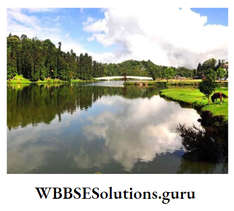
Chapter 8 West Bengal Tourism
Tourism is the most prospective industry in West Bengal. West Bengal with its snow-capped peaks of the Himalayas in the north and the blue waters of the Bay of Bengal in the south is famous for tourism to the people of India as well as abroad.
West Bengal is amongst the 10 (ten) leading states of India in tourism. The number of tourists has also increased in the last few decades.
In 2011-12 more than 12 lakh tourists from foreign and about 20 million tourists from different parts of India visited West Bengal.

Causes Of Development Of Tourism
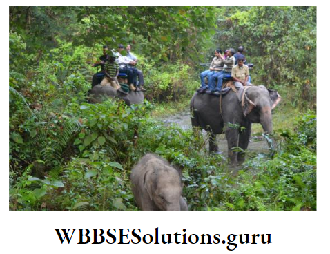
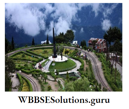
There are many places in West Bengal with natural scenic beauties such as places of Darjeeling Himalayas; Forests of Duars, Sundarban; Coastal Plains of Digha, Shankarpur, Mandarmani etc.
There are also many places of historical importance in Murshidabad and Maida. Many people visit West Bengal for medical treatment in Kolkata.
Many people also visit Kolkata which is the centre of education, art and culture, sports as well as trade and commerce. Most places of West Bengal are connected by modern rail road transport system. In most places of West Bengal hotels, resorts etc.
are well developed. Important tourist spots of West Bengal are Darjeeling, Kalimpong, Kurseong, Duars, Koch Bihar, Malda, Baharampur, and Murshidabad.
Mukutmanipur, Jhargram, Bishnupur, Digha, Shankarpur, Bakkhall, Sundarban, Ayodhya hill, Furfura Sharif, Mayapur etc.
Problems Of Tourism In West Bengal
In comparison to the services provided in rail-road, airways and waterways of Maharastra, Karnataka, Delhi, Goa, and Andhra Pradesh the services of those facilities in West Bengal are not satisfactory.
Excepting a few centres, most of the tourist spots of West Bengal are not well communicated. Hotels and resorts are not also satisfying the demands of tourists in many tourist spots.
Many historical tourist spots are losing their attraction to tourists due to a lack of maintenance.
Prospects Of Tourism
Tourism provides jobs to many people as well as it earns a lot of foreign money. Considering such importance of the industry attention has been given to the development of infrastructural facilities.
Many tourist centres have been linked with airways and helicopter services. So, the future of Tourism seems to be prospective.
Chapter 8 West Bengal Information Technology Industry (I.T.)
Information Technology is a newly developed industry in West Bengal. Information technology is the activities related to storing, retrieving, transmitting and manipulating data for human needs through computers and telecommunication equipment.
The information technology industry involves all the work related to information technology, such as computer hardware, software, electronics, semiconductor, the internet, e-commerce, telecom equipment, computer services etc.
In West Bengal, Information technology has been developed centring Kolkata. Sector-V of Saltlake close to Kolkata is the most important I. T. hub of not only West Bengal but of the whole of Eastern India.

Causes Of Development Of Information Technology
At present almost every aspect of human life, such as education, medical treatment, communication system, trade, weather analysis, defence etc.
depend on information technology. Plenty of skilled and experienced labour is available in and around Kolkata. There is the rapid growth of this industry in West Bengal as Kolkata is the most important centre of information technology.
Plenty of skilled and experienced labour is available in and around Kolkata. There is a rapid increase in the use of information technology in agriculture and industry.
Infrastructural facilities have also developed in the Sector-V area of Salt lake city. The government is taking necessary actions to develop centres for information technology at Haldia.
Siliguri, Durgapur and other important cities and towns of West Bengal.
Problems Of I.T. Industry
Modern and high-tech infrastructural facilities as developed in Bangaluru, Hyderabad are lacking in West Bengal. Road barricades, strikes etc. are the problems faced by this industry. Monetary affluence is also not enough.
Prospects Of I.T. Industry
Skilled and experienced I.T. labour is abundant in West Bengal. The government is taking necessary plans for the growth of this industry. So the future of this industry is quite bright.
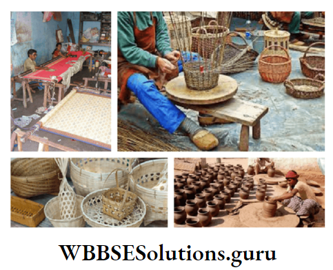
Chapter 8 West Bengal Small Scale And Cottage Industries Of West Bengal
Small-scale industries are localised in urban and semi-urban areas with a limit of capital investment of a small amount.
Cottage industries are carried out by the artisans in their cottages with their family members. The cottage industry invests a very small amount of capital.
The advantages of small-scale and cottage industries are
- Less investment of capital,
- Involvement of a few labours,
- Carried out at home apart from another livelihood,
- It is not much skill oriented etc. A variety of such industries have developed in West Bengal like shola work, handloom, zari work, silk work, brass work,
- Pottery, cane work, mat making etc.

In different corners of West Bengal cottage industries are scattered. The most important centres are the handloom industry of Santipur
Fulia, Dhanekhali of Nadia district.
Pottery of Krishnanagar, silk industry of Baharampur in Murshidabad district; brass work at Kagra, Nabadwip; mat making of Purba Medinipur district.
cutlery works of Kanchannagar of Purba Bardhaman district, leather and wood works of Santiniketan in Birbhum district and cane work of Jalpaiguri and Koch Bihar districts.
At present small scale and cottage. industries of West Bengal are facing problems like scarcity of capital and raw materials, competition from large-scale industries etc.
But this industry can provide jobs to many people as well as can earn foreign money also. Now the Government is trying to give monetary incentives, training to improve skills etc.
Chapter 8 West Bengal Major Cities Ports And Tourist Sites Of West Bengal
The urbanisation of settlement along with developments in agriculture, industry and transport system is responsible for the development of many towns and tourist places in West Bengal.
But ports are few as the coast of West Bengal is not very long.
Important Cities
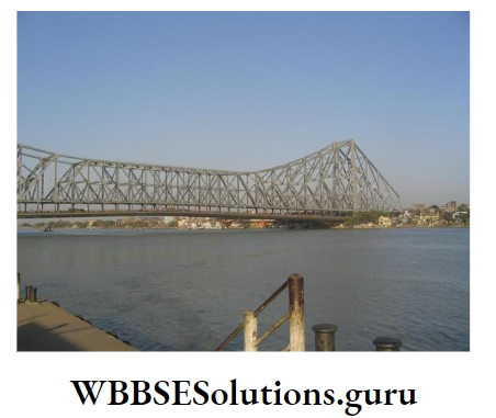
Kolkata is the most important city, and port as well as the tourist centre of West Bengal. Kolkata is also the capital of West Bengal, the principal industrial centre and an important centre of education, culture, trade and communication of the state.
Other important towns of West Bengal are Asansol, Durgapur, Haldia, Bardhaman, Siliguri, Haora, Kharagpur, Baharampur, Darjeeling etc.
Headquarters of all the districts are also important towns, such as Tamluk, Medinipur, Puruliya, Bankura, Suri, Krishnanagar, Barasat, English Bazar, Balurghat, Raigunj, Koch Bihar, Jalpaiguri, Alipurduar, Jhargram etc.
Ports
Two important commercial ports of West Bengal are Kolkata and Haldia. Haldia is actually a complementary port to Kolkata.
Other ports of West Bengal are known as fishing ports, such as Shankarpur, Diamond Harbour, Frezergunj etc. There is a possibility of developing of a new port at Sagardwip in 24 Parganas (S).

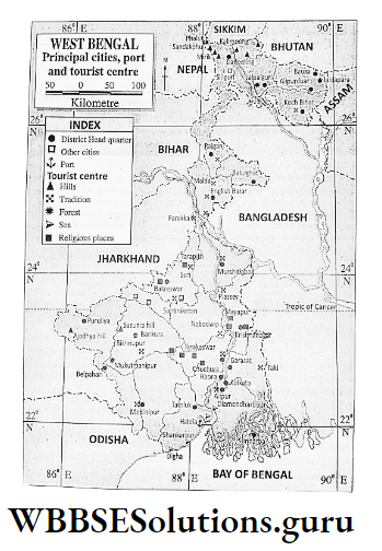
Tourist Spots
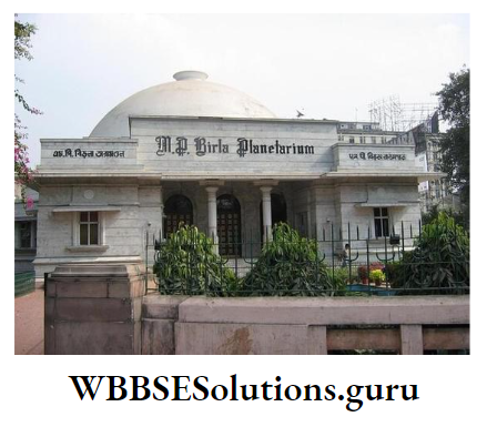
Kolkata is the most important tourist place of W.B. It is famous for the Victoria Memorial, Birla Planetarium, Nicco Park, Museum, Zoo etc.
The tourist places of West Bengal are famous for various reasons such as hills, forests, seaside, religious importance, historical importance etc.
Such tourist places are Darjeeling, Kurseong, Kalimpong, and Ayodhya which are famous for mountains and hills; Sundarban, Duars, and Jhargram are famous for forests.
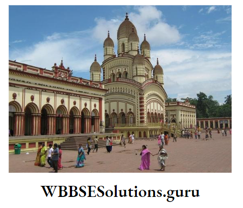
Digha, Shankarpur, and Bakkhali are famous for the seaside; Tarakeswar, Bandel, Furfura Sharif, Mayapur, and Dakshineswar are famous as religious places; Gour, Murshidabad are famous as historical places.
Mukutmanipur is a famous tourist place for its reservoirs and Santiniketan is famous as the centre of education.
There are many tourist places in West Bengal such as Tarapith, Bakreswar, Susunia Hill, Jairambati, Kamarpukur, Plassey etc.