
WBBSE Chapter 1 Exogenetic Processes And Resultant Landforms
Exogenetic Processes
The surface of the earth is not even everywhere—either very high or flat, somewhere it is sloping and in other places uneven. All these together, are referred to as ‘Landform’.
Landforms are of two types—
- Primary Landforms and
- Secondary or Sequential Landforms.
Primary landforms are formed by earth movement and tectonic movement which are caused by endogenetic forces.
Primary landforms, such as mountains, plateaus and plains, (that you have read about in class IX) are modified by exogenetic forces to develop Secondary landforms.
WBBSE Notes For Class 10 Geography And Environment
WBBSE Chapter 1 Exogenetic Processes And Resultant Landforms Role Of Exogenetic Processes on Formation Of Landforms
Exogenetic processes are active on the earth’s surface continually Earth’s surface is modified by the natural agents of gradation like rivers, glaciers, wind, sea waves, groundwater etc.
These processes can be identified by small and minute sculpturing on primary landforms.
These processes are active very slowly for a long time, and sources of energy, other than gravitations originating from solar energy, gradation, aggradation and degradation are three important features of secondary landforms.
River is the most important agent of exogenetic forces. River works pathway by aggradation as well as degradation.
Graduation
Levelling of the undulated surface of the earth is the aim of gradation. This process of levelling is active up to a certain limit known as the Base level of erosion.
So graduation is the levelling of the earth’s surface up to Base level. Gradation includes two processes Aggradation and Degradation.
Aggradation
Filling up of lowlands through the deposition of sand, silts and pebbles by the agents of gradation is known as Aggradation.
Features of aggradation are delta, sandbars and floodplains. The Ganga Delta is the result of aggradation by the river Ganga.
Degradation
Lowering of the earth’s surface by the agents of gradation like weathering, mass wasting, rivers, and glaciers is known as Degradation.
WBBSE Class 10 Geography Chapter 1 Notes
Example. transformation of lofty mountains through Residual mountains, erosional plateau and ultimately into erosional plains or peneplains. So, lowering the height of a landform is the main aim of degradation.
WBBSE Chapter 1 Exogenetic Processes And Resultant Landforms Works Of River And Resultant Landforms
The river plays an important role as an agent of gradation on primary landforms. A river is actually, a part of the most important natural phenomenon, the water cycle.
River As A Part Of Hydrological Cycle:
Due to the evaporation of surface water, water vapour is picked up by the air above. The moist and warm air rises and at high altitudes becomes cooled.
Water vapour turns into water droplets which become bigger and float as clouds and finally fall as rain by the gravitational pull of the earth.
Ultimately, rain or snow melt-water goes back to the sea or lake as a river to complete the hydrological cycle or water cycle. So river plays an important role in the completion of the water cycle or hydrological cycle.
River Basin:
An area drained by a river, its tributaries and distributaries is referred to as a River basin. In other words, a river basin drains all of its water through a central channel of water or a river.
The bigger the area of the River basin the role played by the river is more important. A river basin is usually, delimited by a water divide.
The river Ganga basin is delimited by the Himalayas in the north and the Vindhya- Satpura-Maikal-Kaimur range in the south river basin.

Interfluves:
An interfluve is a narrow, elongated and plateau-like landform between two river valleys. It is better defined as an area of higher ground between two rivers in the same drainage system.
The interference may have a rounded and less rugged appearance. When adjacent River basins are separated by a line or, Especially by a single range of hills or mountains the term is referred to as water divide or watershed.
Amarkantak in Madhya Pradesh-Chhattisgarh is the water divide between the Narmada and the Son river basins.
Usually, adjacent river basins are formed on opposite sides of the highland. Rivers of the adjacent basins also flow in opposite directions.

Courses Of River
From source to mouth the path along which a river flows is known as river course.
Depending on the flow of water and the works of the river, the course of a river can be divided into three divisions—Mountain or Upper course, Plain or Middle course and Delta or Lower course.
WBBSE Class 10 Geography Chapter 1 Notes
Upper Course :
In the mountainous regions, the upper course of a river extends from the source of the river to the plain land where the river leaves the l highland. The upper course of the river Ganga extends from the Gangotri glacier at Gomukh to Hardwar.
Middle course :
In the middle course, the river flows through plain land. The middle course of the river Ganga extends from Hardwar to Rajmahal hills.
Lower course :
In the lower course, a river flows through flat land. The lower course of the river Ganga extends from Rajmahal hills in Jharkhand to the Bay of Bengal.

Works Of River
A river works in three ways
- erosion
- transportation and
- deposition.
In the upper course due to steep slope erosion, especially, vertical erosion is predominant along with transportation.
In the Middle course, the slope of the land becomes gentle so the velocity of the river is moderate. Therefore, Lateral erosion transportation along with little deposition are dominant works of a river.
In the Lower course the land is flat deposition, so is the only work of the river.
Erosion
River erosion takes place in four ways
- Soluble Rocks like limestone dissolve in river water and are removed by the process of Solution.
- By Hydraulic Action river picks up loose stones, and pebbles from the river bed and valley walls.
- Corrosion or Abrasion is the process by which stones, pebbles, boulders etc. carried by a river erode the river bed and valley walls.
- Attrition is the grinding action of stones, pebbles and boulders amongst themselves to produce fine particles.

Transportation
River transports the eroded materials called load. Load carrying capacity of the river depends on
- The volume of the river water,
- The velocity of the river and
- Size of transported materials.
River transports its load through four processes
- Soluble particles are carried by the Solution,
- The finest particles are carried in Suspension,
- By Saltation small pebbles leap up from the river bed intermittently and
- Big pebbles and boulders are rolled along the river bed by Traction.
WBBSE Class 10 Geography Chapter 1 Notes
Deposition
River deposits its load depending on three conditions
- When the volume of river water decreases,
- If the slope of the land becomes moderate and
- When the number of loads increases.
Landforms Produced By River
The combined action of river erosion, transportation and deposition develop different types of landforms.
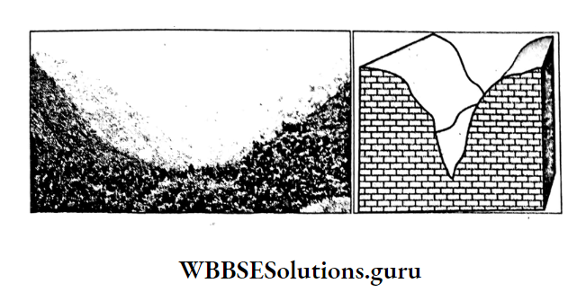
V-Shaped Valley:
Due to vertical erosion and landslides narrow v-shaped river valley is formed in the mountain course.
In the plain course with increasing lateral erosion wide V-shaped valley and in the delta course where vertical erosion is stopped broad V-shaped valley is formed.
Interlocking Spur:
mountain course, projections from both sides of the valley wall i.e. spurs remain interlocked with each other and the young river is bound to move through in a winding course.

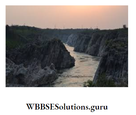
Gorge:
A Gorge is formed when the river valley becomes very deep and narrow, for Example. Indus Gorge in Kashmir.
Class 10 Geography And Environment Chapter 1 Solutions
Canyon:
In the dry regions, lateral erosion becomes insignificant and a V-shaped valley is formed. This is known as Canyon, for Example. Grand Canyon, is the largest canyon in the world river in the USA.

Rapids:
Rapids are part of the river where the river descends over a series of small steps caused by gently dipping outcrops of hard rocks. Example. In Africa, on the river Nile, there are six rapids from Khartoum to Aswan.
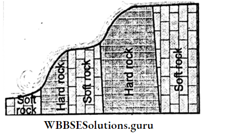
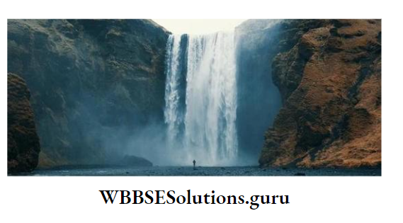
Waterfall:
When a river descends down from a higher point to a lower point due to horizontally arranged alternate soft and hard rocks, a waterfall is formed.
Yog or Gersoppa waterfall on the river Kaveri is the highest (275 m) waterfall in India.
Plunge Pool :
It is a deep pool formed at the base of a waterfall into which river the water plunges and is cut out by the whirling round of boulders and stones.

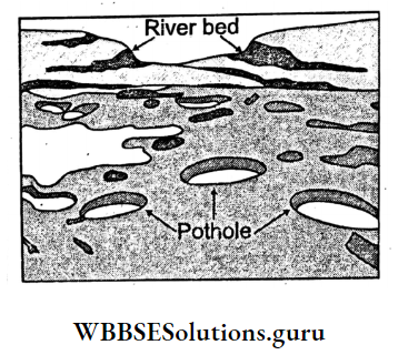
Pothole:
Tiny holes formed on the river bed due to strikes or stones or pebbles by the process of abrasion are called potholes.
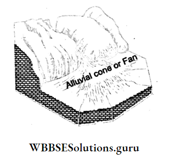
Alluvial Fan Or Cone:
At the foot of the mountains where the slope of the land is reduced, suddenly the velocity of the river is also checked.
Consequently, most of the river load like stones, pebbles are dropped to form a cone or fan-shaped landform known as the Alluvial cone or Alluvial fan.
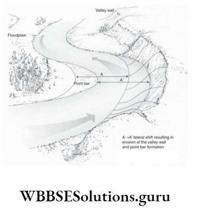
Meander :
Due to obstruction and low velocity of the river, it flows through a winding course which is known as Meander after the name of the river Meanderez in Turkey which is very much winded.
Example. River Ganga in Varanasi. A cliff is formed where the river erodes The bank i.e. the concave side of the meander.
Slip-off-slope (gentle slope) is formed where the river deposits the eroded materials i.e. the convex side of the meander.

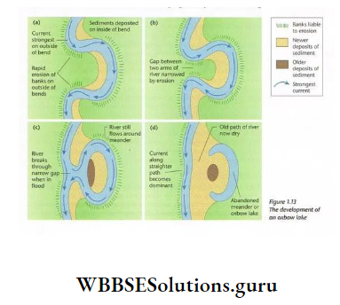
Oxbow Lake :
In the middle as well as lower course, the river meander becomes very much prominent to form a loop as the river cuts the concave slope and deposits silt on the convex slope of the meander.
Class 10 Geography Chapter 1 Question Answers
Finally, only a narrow neck of land is left out. Consequently, the river cannot flow straight and leaves its old course which takes the shape of a horseshoe and is called a horse-shoe or ox-bow lake, for Example. the river Ganga near Patna.
Flood Plain :
In the rainy season in the middle and lower courses river floods the adjoining areas where silts are -deposited. Due to repeated floods, a thick plain is formed known as a Flood Plain.
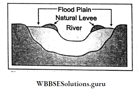
Natural Levee :
During floods deposition of silts takes place along the two banks of a river forming an embankment called a Natural levee.
Delta:
At the mouth of a river, silts are deposited forming a triangular landmass called a delta which looks like the fourth letter Δ (delta) of the Greek Alphabet, For Example, the delta formed by the river Ganga is the largest delta in the world.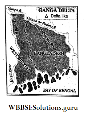
Based on shapes deltas may be of different types
- The arcuate delta is a fan-shaped delta with a rounded outer margin (bow-shaped), the arc of the fan spreading into the sea, for Example. the Nile Delta.
- Bird’s foot delta is best explained by the Mississippi Delta which has several main branches like the foot of a bird extending into the Gulf of Mexico.
- A few rivers like Ebro in Spain have tooth-like projections at their mouths and these are known as Cuspate Delta.

Estuary:
Many rivers do not form deltas if the river load is drained into the sea due to the greater velocity of the river by joining a number of tributaries or by the flushing action of the tidal waves.
For example. the river Ob in Russia has the largest estuary in the world.
Conditions Favourable For The Formation Of Delta
Rivers which have formed deltas are favoured by the following conditions :
- The slope of the land below the sea at the mouth of the river must be less.
- The river should be long and the number of tributaries should be large so that amount of silt becomes maximum.
- The salinity of the seawater at the mouth of the river should be high so that the deposition of silts will be more.
- Effects of High and Low tides at the mouth of the river should be less.
- The flow of the river at the mouth should be less.
- Delta formation accelerates if the wind blows from the opposite direction of river flow.
- Presence of a partially landlocked sea at the mouth of a river favours delta formation.

Effect Of Global Warming On Active Delta Of Ganga-Padma-Meghna (The Sundarbans)
River Padma, the principal distributary of the river Ganga enters Bangladesh and combines with the river Meghna to drain into the Bay of Bengal.
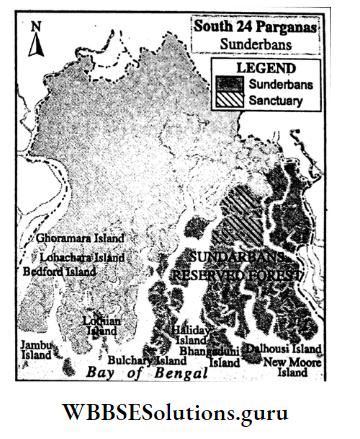
The delta formed by Ganga-Padma- Meghna is the largest delta in the world. In the southern part of the delta, there is Sundarban the largest contiguous Mangrove forest in the world.
As it is part of an active delta so land building processes are still going on. There are, approximately, 102 islands of which 18 are uninhabited with a total of 9630 sq. km area.
Class 10 Geography Chapter 1 Question Answers
But due to global warming, the Sundarbans face several challenges, the most striking of which is the rising sea level by nearly 5 mm annually.
According to scientists, there are about a dozen vanishing islands under the sea. For the first time, Lohachara an inhabited island once the home. of 10,000 people have disappeared beneath the rising sea due to global warming.
Similarly, two-thirds of the nearby populated island, Ghoramara has also been permanently submerged underwater. New Moore or Purbasha Island was a small offshore island that emerged in the 2000s.
But in 2010 it was declared that the island has been completely submerged by rising seawater.
The Sundarbans also faces challenges like a threat to the health of mangrove forests and the quality of soil and crop types due to severely increasing salinity; changes in fishing pattern; frequent cyclones and erratic monsoon rain.
All these, together, are responsible for damaging the ecology and humanity of the Sundarbans.
WBBSE Chapter 1 Exogenetic Processes And Resultant Landforms Works Of Glacier And Resultant Landforms
Glaciers are the moving ice and the most powerful gradational agent.
Concept Of Glacier
At present Glacial activity is restricted in the polar regions and in the high mountains.
But in the geological past during Ice Age, about 30,000 years back glaciers were active even in temperate latitudes where imprints of glacial activities are still found today.
Origin Of Glacier
Above the snowline, snowfall accumulates a huge amount of snow, the pressure of which turns the snow below into ice.
In Germany, fine and light snow is termed Tern’ and in France, it is termed ‘Neve’ which gradually turns into ice and eventually into a glacier.
A huge mass of ice when moves down the hill slopes by the gravitational force is known as a glacier.
Glacier Is The Largest Fresh Water Source Of The World :
Nearly 97% of the water reserve of the world belongs to the saline sea. Rest 3% as fresh water. belongs to the land.
About 69% of land water as fresh water is confined in ice or glacier, 30% is retained as groundwater and only 1% belongs to rivers, ponds, canals etc.
Class 10 Geography Chapter 1 Question Answers
So, the glacier is the most important source of fresh water. But due to global warming, glaciers are melting and mixing with seawater. So it results in rising sea levels as well as diminishing availability of fresh water.
Types Of Glacier
Glaciers are of three types.
- Mountain or Valley glacier descends through the mountain valleys, for Example. Gangotri glacier, Siachen glacier.
- A continental glacier or Ice sheet is a mass of ice which covers extensive areas of a continent. Lambert Glacier of Antarctica is the largest Ice sheet glacier in the world.
- Piedmont Glacier is formed at the foot of a mountain where several glaciers converge to form an extensive mass of ice, for Example. Malaspina in Alaska.
Snowline:
The altitude above which snow accumulates throughout the year is known as a snowline. The altitude of the snowline depends on latitude, the slope of the land, altitude, seasonal variation, wind direction, wind velocity and air temperature.
Snowline lies at sea level (0 m) in the polar region, 2000-2500 m in the temperate region, 4000-4500 m in the tropical region and above 5000 m in the equatorial region.

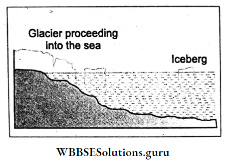
Iceberg :
Iceberg is a huge mass of ice broken from a glacier that floats on the ocean water. Only 1/9th of it remains above sea level.
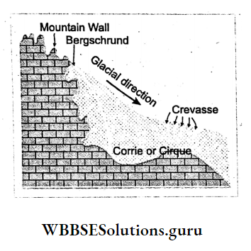
Crevasse And Bergschrund:
Crevasse is a deep crack formed on the glacier. A very large crevasse formed near the head of the glacier is known as Bergschrund.
For mountaineering, these crevasses and bergschrunds are very much dangerous as they cannot be identified when covered with light snow.
Works Of Glacier—Erosion Transportation And Deposition
Glacier works in three ways
- erosion,
- transportation and
- deposition.
Erosion Of Glacier
There are two processes of erosion
- Plucking—Picking up of stones and pebbles from the mountain wall by the glacier is known as plucking.
- Abrasion—Wearing away of rocks beneath the glacier due to frictional activity producing striations, grooving etc. or rock pebbles is known as abrasion.
Class 10 Geography Chapter 1 WBBSE Solutions
Resultant Landforms Of Glacial Erosion :
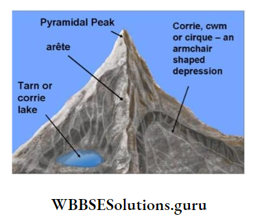
Corrie:
The moving ice usually forms. depressions on the mountain wall, as if, an armchair-shaped hollow is formed.
This hollow is known as Corrie and Cirque by the French.
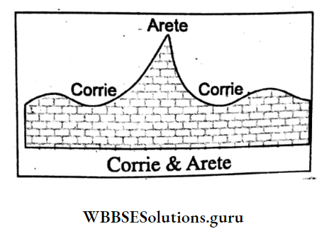
Arete:
When a number of corries or cirques develop on a mountain; glaciers cut their mountain walls and gradually a sharp edge is formed known as Arete.
Pyramidal Peak:
Sometimes, several cirques may develop on all sides of the mountain and the glaciers, usually, cut their headwalls until the mountain peak takes the shape of a pyramid.
The top of the peak is called the pyramidal peak. A sharp pointed pyramidal peak is called Horn. Example. Matterhorn of Switzerland and Neelkantha Peak in India are good examples of Horn.
Truncated Spur:
When the tributary valleys of interlocking spurs are occupied by glaciers, the noses of the spurs are cut by the process of abrasion. As a result, truncated spurs are formed.

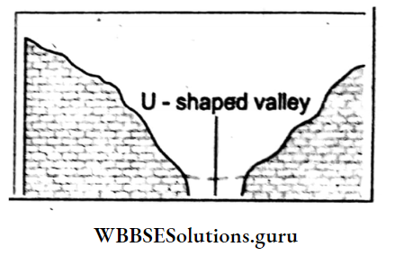
U-Shaped Valley Or Glacial Trough:
A glacial valley has a wide flat floor with steep walls and looks like the English letter ‘U’.
The ‘U’-shaped valley is formed when the V-shaped valley of a pre-existing river has been over-deepened and widened by the passage of a glacier, for Example. St. Lawrence Valley in the U.S.A.
Class 10 Geography Chapter 1 WBBSE Solutions
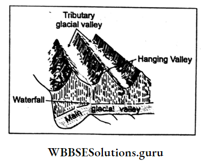
Hanging Valley:
It is formed by a tributary glacier which forms a valley less deep than that of the main glacier.
When glaciers melt, it is found that the tributary valley remains higher than the main valley and appears to be hanging over the main valley.
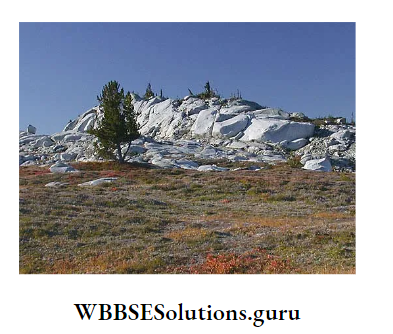
Roches Mountonnees:
These are the hillocks of rocks that are polished by glacial abrasion on the upstream side to form a gentle slope and remain rough and irregular with a steep slope due to plucking on the opposite side.
They appear to lie on the mountain like sheep and hence, are also called sheep rocks.
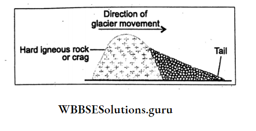
Crag And Tail:
A glacier may find a soft rock to be protected from its erosion by the presence of a hard rock which is called a Crag and the soft rock remains as a Tail.
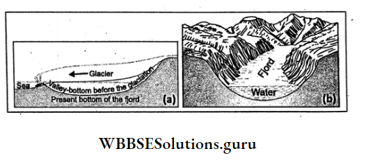
Fjord:
A valley glacier extending up to the coast erodes the land below sea level forming an inlet through which sea water enters the land.
This is known as Fjord, These are common in Norway and Sweden. Small and shallow fjords are known as Fjords.
Transportation Of Glacier
Carrying away of eroded materials called moraines embedded in a glacier is known as transportation.
Deposition Of Glacier
Moraines are carried by a glacier when dropped on the glacial valley the process is known as Deposition.
Depositional works may be grouped into two types
- Deposition on the upper part of the mountain and
- Deposition on the foothills of the mountain.
Class 10 Geography And Environment Notes WBBSE
Deposition On The Upper Part Of The Mountains
Moraines:
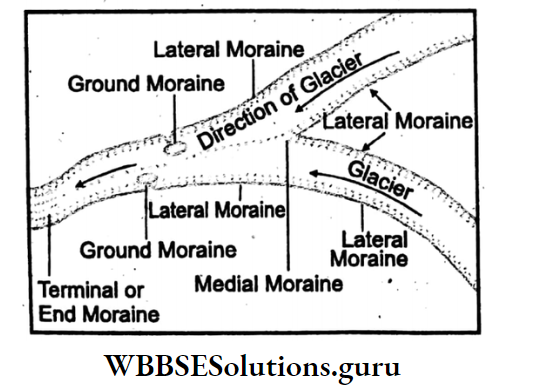
Sand, clay, gravel deposited by a glacier are called moraines. Moraines are of different types
- Lateral moraines are deposited along the margins of a glacier,
- When two glaciers meet, the adjacent lateral moraines combine to form Medialmoraines,
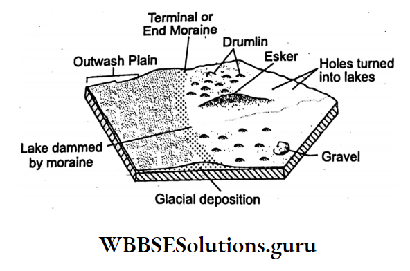
- Terminal or End moraines are formed at the end of a glacier.
Deposition At The Foothills Of A Mountain
At the foothills of a mountain, glaciers, as well as glacier-melt rivers together, form various types of landforms. Hence, these landforms are known as glacial-fluvial landforms.
Outwash Plain:
At the end of Terminal Moraine, streams derived from the melting of ice form a plain land by the deposition of sand, clay and gravel. This is known as Outwash Plain.
Class 10 Geography And Environment Notes WBBSE
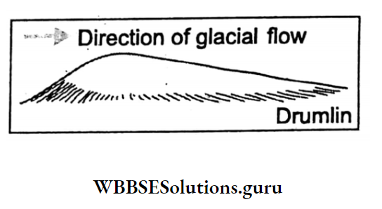
Drumlins:
These are low elongated smooth and rounded hills like whale-back hummocks composed of boulder clay. The landscape scattered with a number of drumlins is called ‘Basket of Eggs terrain’. These are common in the Lake Region of the U.S.A.
Esker:
These are long and narrow, winding steep sided low ridges composed of sand and gravel. These are common in Scandinavia.
Kame:
A triangular feature made by a number of mounds of sand and gravel is known as Kame. A number of Karnes when developing steps are known as Kame terraces.

Kettles:
These are depressions formed by the melting of a huge chunk of ice and are found on the outwash plain.
WBBSE Chapter 1 Exogenetic Processes And Resultant Landforms Works Of Wind And Resultant Land-Forms
Predominate Wind Action
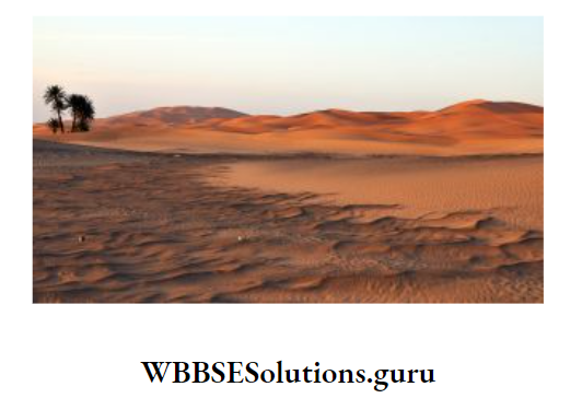
Wind as an agent of * gradation is active in arid and semi-arid and the coastal regions. There are 7 large deserts in the world.
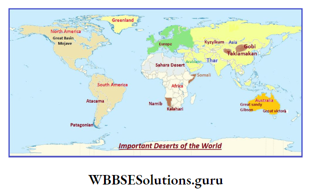
These are the Sahara and Kalahari in Africa, Atacama in South America, Soneran in North America, the Great Deserts of West and Central Australia, the Arabian Desert of Asia and the Thar desert of India-Pakistan.
In the deserts, wind action is predominant because
- There is little vegetation to hold firmly loose surface materials and at the same time wind can blow swiftly without any obstruction,
- Variations in temperature during the day and night cause mechanical weathering. In coastal regions, sea waves cut the coastal land and produce large amounts of sand particles which are blown by the wind uninterruptedly helping in wind erosion.
- South-west monsoon wind deposits sands in Digha and Contai coasts blown away from Andhra and Odisha coasts.
Class 10 Geography And Environment Notes WBBSE
Formation Of Sand Particles
Sand is a weathered naturally occurring fragmentary material ranging in size between 0.06 and 2.0 mm in diameter.
In deserts due to thermal variation in day and night temperature, rocks are disintegrated by the processes of granular disintegration, and block disintegration.
Exfoliation into grains which by the process of attrition themselves turn into fine grains known as Sands.
In coastal regions, rocks are also disintegrated by sea waves through the processes of abrasion, hydraulic action, attrition etc. into fine grains i.e. sands.
Works Of Wind :
Wind sculptures the earth’s surface through three processes
- Erosion,
- Transportation and
- Deposition.
Wind Erosion
Wind erodes in three ways
- Abrasion,
- Deflation,
- Deposition.
1. Abrasion :
This is the process by which the wind drives sand particles against an exposed rock which becomes scratched, polished and grooved. It is most effective near the base of a rock within one metre above the ground.
Resultant Landforms Carved Out By Wind Abrasion:
Gour :
Wind abrasion causes wearing away of softer rock layers of projecting rock masses and carving them into pillars called Rock pedestals.
Generally, the undercutting is more near the base of the rock and as a result, a mushroom-shaped rock is formed known as Gour which is common in the Sahara desert.

Class 10 Geography And Environment Notes WBBSE
Zeugen :
When horizontally arranged Gour alternate layers of hard and soft rocks are exposed to wind abrasion, soft rocks are removed quickly. But the hard rocks stand out uneroded as ridges which are known as Zeugens.

Yardang :
When vertically arranged alternate layers of hard and soft rocks are exposed to wind abrasion, columns of soft rocks wear away quickly leaving behind the pillars of hard rocks which are called Yardangs.
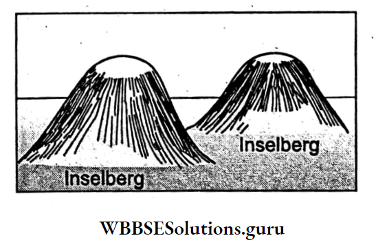
Inselberg :
This is a German word which means ‘island mountain’, these are isolated hills With steep slopes and rounded tops, often composed of granite and gneiss produced by wind abrasion.
These are common in the Kalahari desert of South Africa and in the West Australian desert.
2. Deflation :
Deflation is the process by which wind lifts and blows sand particles. Thus it lowers the desert surface and forms a depression.
Deflation Hollow :
Strong wind deflation causes the formation of depressions, for Example. Quattara depression in Egypt.

3. Deposition :
The ultimate products of wind attrition between the pebbles are sands.
WBBSE Class 10 Geography Chapter 1 Notes
Wind Transportation
Eroded materials are transported by the wind in three ways
- Suspension,
- Saltation And
- Traction.
1. Suspension:
Fine sand particles are blown away by the wind at distant places.
2. Saltation:
Stones and pebbles are moved away by wind through saltation process i.e. by dropping and jumping of stones in the air.
3. Traction:
Through this process, bigger stones are dragged away by the wind along the surface of the earth.
By wind transportation area of the desert increases. Thus the Rajasthan desert in India has extended eastwards. This is known as desertification.
Wind Deposition
Huge amounts of sand carried by the wind are dropped when obstructed by a highland or when the velocity of the wind decreases.
Landforms Produced By Wind Deposition
Important landforms produced by wind deposition are sand dunes and loess plains.
Sand Dunes
Dunes are hills of sand formed by wind deposition. The wind being obstructed by natural vegetation, boulder or any kind of other obstructions deposits sands to form dunes.
According to Bagnold, a famous scientist, Dunes are of two types
- Barkhans and
- Seif dunes.
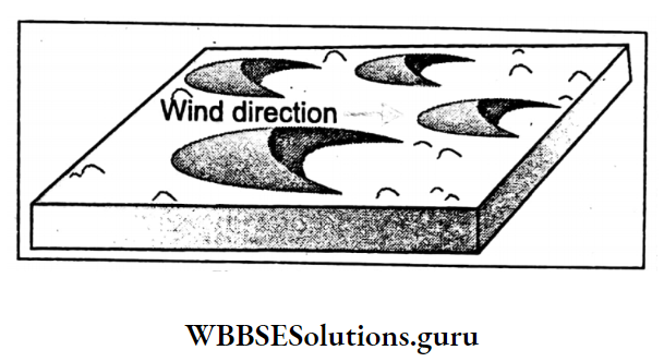
1. Barkhans:
This type of dune is formed transversely to the wind direction. So they are also known as transverse dunes. Crescent-shaped transverse dunes are called Barkhans.
These are common in the deserts of the Sahara, Arabia, Atacama and Kalahari. The windward slope of the Barkhan is gentle and convex, while the leeward slope is steep and concave.
Barkhan tapers off at two ends to two points called Horns. The average height of Barkhan varies between 15 and 30 metres. They are usually temporary and shifting in nature.
WBBSE Class 10 Geography Chapter 1 Notes
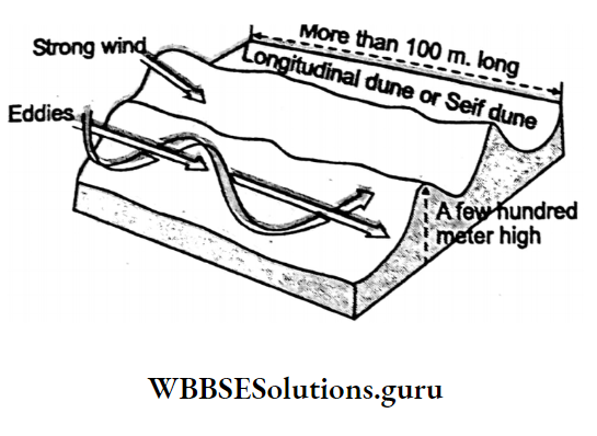
2. Seif Dunes :
‘Seif’ is an Arabic word which means ‘sword’. There are long, narrow sand dunes lying parallel to the wind direction. So they are also known as longitudinal sand dunes.
These are commonly found in the deserts of Arabia, the Sahara and the Thar in India. Seif dunes vary in length from a kilometre to a hundred kilometres.
Their height varies between 150 and 200 m. They lie parallel to each other. The top of the dunes is sharp. These are formed where the velocity of wind is high.
In Rajasthan, they are extended from southwest to northeast as they lie parallel to the direction of southwest monsoon wind.
Loess
Fine sand particles of a desert when transported by wind are dropped at a distant place. Gradually, these sand particles accumulate there to form a thick plain land called Loess.
The best example is the Loess plain formed along the Hwang-Ho river valley in China where sand carried away from the Gobi desert is deposited by wind.

Combined Actions Of Wind And Running Water :
In the desert, sometimes wind in combination with running water work as an agent of gradation.
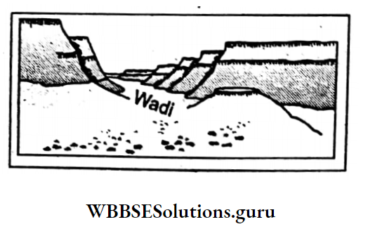
Wadi
‘Wadi’ is an Arabic word which means ‘dry valley’. In the desert a short spell of rain results in flood. As a result, temporary rivers or gullies are formed. After the recession of water gullies are left out as dry valleys. These are known as a wadi.
Pediment
A sloping stony plain formed by the combined action of wind and running water at the foot of a mountain is called a pediment. It is an erosional plain formed at the base of a surrounding mountain scarp.

Bajada
A triangular or fan-shaped alluvial land formed by running water at the lower part of the pediment may join with others to form a plain land which is known as Bajada.
it is a depositional feature formed by intermittent streams.

Playa
A shallow lake formed by a number of intermittent streams in a basin enclosed by mountains. It is a temporary lake and highly saline.
Expansion Of Deserts And Measures To Control:
- Usually, either naturally or by human interference deserts expand. Physical causes are
- Sands blown by the wind and deposited in the adjoining areas may extend into a desert,
- Frequent and prolonged dry weather increases aridity and drought for consecutive years
and climatic changes due to global warming. Human interferences like
- Deforestation
- Overgrazing,
- use of unscientific methods of agriculture. As a result, the Thar and the Sahara deserts have extended east and southwards respectively.
To control the extension of the desert a few measures have been taken in the Thar and the Sahara deserts. In Thar desert, Desert Afforestation Research Station was set in Jodhpur in 1952.
Afforestation started in 1958 in the Command Areas of the Indira Gandhi Canal.
Other programmes to control desertification are sand-dune fixation work, silvopastoral plantations, village fodder and fuel wood plantation, shelterbelt plantation, ecological regeneration, and restoration and rehabilitation of degraded desert.
Afforestation in barren hills, reseeding of old pasture and farm forestry, rainwater harvesting and recharge of groundwater. In the Sahara measures that have been taken to control desertification are making water free of salt with solar energy, and development.
wind break, sand shield at the margin of the desert and envision (The Great Green Wall (GGW) to stop desertification. It is 15 km wide and 8000 km long, a living green wall of trees, bushes and birds to the south of the Sahara.