
WBBSE Chapter 2 Atmosphere
Concept Of Atmosphere Composition
Concept of Atmosphere:
The atmosphere is an insulating blanket which protects the Earth from the intense heat and light of the sun and helps living organisms to survive.
It is held by the gravitational pull of the earth extending up to 10,000 km from the earth’s surface.
97% of the atmospheric elements are confined to only 29 km from the earth’s surface due to the gravitational force of the earth and the pressure of the upper layers of the atmosphere. Beyond 10,000 km there is space which is infinite.
WBBSE Notes For Class 10 Geography And Environment
Different Elements Of Atmosphere
The atmosphere is chiefly composed of three components—gases, water vapour and dust particles.
Gaseous Elements
The atmosphere comprises many gases. Among these gases, Nitrogen constitutes nearly 78% (78.08) of the atmosphere.
Oxygen, the second most important gas contributes nearly 21% (20.94) of the atmospheric content. The rest 1% of the atmosphere comprises of Argon (0.93%), Carbon dioxide (0.033%), Helium, Hydrogen, Krypton, Methene, Neon, Ozone, Xenon etc.
Amongst these gases nitrogen, argon, neon, helium, krypton and xenon are known as inert gases (these gases do not take part in a chemical reaction).
The proportion of these gases remains constant up to a height of 90 km from the earth’s surface.

Water Vapour
This is one of the most important elements of the atmosphere. This is the gaseous state of water. About 90% of atmospheric water vapour is confined within 6 km from the earth’s surface.
WBBSE Class 10 Geography Chapter 2 Notes
It accounts for nearly 1.4% of the atmosphere by volume. But this amount is very variable according to latitude and season. In the Tropical region it is only 4% while in the Polar region, it is as low as 0.0006%.
Dust Particles
Dust particles are also known as aerosols. It is also a variable element of the atmosphere. It is found in deserts, seasides, industrial towns, volcanic ashes etc.
WBBSE Chapter 2 Atmosphere Layers Of Atmosphere
The atmosphere can be divided into different layers based on
- Chemical composition and
- Variation in temperature.
Atmospheric Layers Based On Chemical Composition And Thermal Variation:
The atmosphere can be divided into two layers based on chemical composition.
Homosphere
‘Homo’ means uniform and ‘sphere’ means region. Up to 90 km above the earth’s surface there is no variation in the proportion of different gases found in the atmosphere.
Heterosphere
‘Hetero’ means dissimilar and ‘sphere’ means region. Above the homosphere, the Heterosphere extends up to nearly 10,000 km.
Different gases of this, layer vary in proportion and thickness and accordingly this layer is divided into four sublayers
- The molecular Nitrogen layer extends up to 200 km above the earth’s surface.
- The atomic Oxygen layer extends from 200 to 1100 km above the earth’s surface.
- The helium layer extends between 1100 km and 3500 km above the earth’s surface.
- The hydrogen layer extends up to 10,000 km above the helium layer.
Atmospheric Layers Based On Variation In Temperature
According to variations in temperature the atmosphere can be divided into five layers
- Troposphere,
- Stratosphere,
- Mesosphere,
- Thermosphere,
- Exosphere and
- Magnetosphere.
Troposphere
This is the lowest layer of the atmosphere. In this layer, temperature decreases at a rate of 6.5°C for every 1000 metre or 1 km ascent.
At the equatorial region, the layer extends upward 18 km, but at the poles, it extends only up to 8 km. This layer contains a sufficient amount of different elements of gases, water vapour, dust particles etc.
WBBSE Class 10 Geography Chapter 2 Notes
So this layer is Known as weather making layer in which clouds and storms are formed. 75% of the gaseous elements of the atmosphere belong to this layer. Air-polluting elements are also blown in this layer.
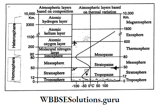
Tropopause
At the upper limit of the troposphere temperature becomes – 55°C which remains constant for 2 to 3 km above Troposphere. This zone of constant temperature is known as Tropopause. A strong ‘Jet stream’ blows in this layer.
Stratosphere
Stratosphere lies above the Troposphere for nearly 50 km thickness. In this layer, temperature increases upward and at 50 km height temperature of the air becomes maximum, nearly 10°C.
There is Ozone (O3) layer because of the concentration of O3. The ozone layer protects the earth’s surface from the harmful rays of the sun.
Water vapour or cloud is absent in this layer except for the Noctilucent cloud. So jet air crafts fly through this layer.
Stratopause
Above the stratosphere at a 50 km height increase in temperature stops this zone is known as Stratopause.
Mesosphere
Mesosphere extends above stratopause for nearly 80 km above the earth’s surface. Temperature decreases with increasing height.
At 80 km, the temperature becomes lowest at about -93°C. Incoming meteors from outer space towards Earth are burnt in this layer. The pressure of air is also very low in this layer.
Mesopause
The height at which in the mesosphere the fall of temperature ceases is known as Mesopause.
Ionosphere
Above Mesosphere the layer of air is known as Ionosphere. In this layer temperature again rises rapidly and becomes nearly 1200°C at the elevation of 500 km.
In this layer ionisation of gas, molecules take place. This layer is known as Thermosphere. Auroras seen in the mighty sky at high latitudes are developed in this layer.
Auroras are probably an effect of magnetic storms i.e. the disturbance in the magnetic field of the earth and electric discharge of the sun during periods of sunspot activity.
From the ionosphere, radio waves are reflected back to the earth which helps maintain the world’s radio communication system.
Class 10 Geography And Environment Chapter 2 Solutions
Exosphere
Above the thermosphere lies the Exosphere. In this layer temperature also increases with increasing height but not so rapidly as it happens in the Thermosphere. At 650 km above the earth’s surface temperature increases to nearly 1240ºC.
Magnetosphere
Beyond Exosphere lies the Magnetosphere which gradually merges into space.
WBBSE Chapter 2 Atmosphere Importance Of Ozon And Its Depletion
In the stratosphere between 24 km and 40 km in height, there is an ozone layer which absorbs ultraviolet rays and other harmful rays of the sun. So it protects the earth and human life from cancer and other diseases.
But emission of Chlorofluro carbon (CFC), nitrous oxide and other gases deplete the formation of ozone (O3) and thus Ozone holes are found in the Arctic and Antarctic regions. So ozone layer must be conserved at any cost.

Heat, Temperature And Global Warming
Air temperature is the warmth of air received by a place from the sunrays measured in degrees Celsius or Fahrenheit with the help of a thermometer.
The sun is the source of this air temperature. Though the earth is about 150 million km away from the sun. It is heated directly or indirectly by the sun.
Insolation, Heat Budget, Processes Of Heating:
Insolation
Insolation is the incoming solar radiation which is about 1/2,000,000,000 part of solar radiation which spreads in all directions with a velocity of about 2,97,600 km per second.
About 35% of insolation is reflected back into space. It varies widely with the variation in nature of the earth’s surface.
The remaining 65% of the insolation is known as Effective Solar Radiation which enters the earth’s atmosphere.
14% is absorbed by dust, carbon the Atmosphere dioxide, and water vapour present in the air. 45% of the insolation, ultimately, reaches the earth’s surface.
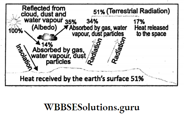
Heat Budge
During the day the earth is heated by the sun. But at night the earth becomes cooled by releasing the same amount (65%) of heat into space. This is known as terrestrial heat balance or heat budget.
Processes Of Heating Of The Atmosphere :
The atmosphere is heated by the following processes :
Radiation:
The earth’s surface is heated by the sun’s rays and the terrestrial heat is radiated from the earth’s surface. This terrestrial radiation warms the lowest layer of the atmosphere.
Conduction:
Cold air from the upper layer comes in contact with the warm lower layer and the heat is transmitted to the upper layers gradually.
Convection:
The air of the lower layer heated by the terrestrial radiation becomes warm and light and it rises while cold heavy air of the upper layers descends to occupy the vacuum. Thus, heat is transferred to the upper layers of the atmosphere.
Advection:
The horizontal transfer of heat through horizontally moving airmass is known as advection.
Direct Absorption:
Elements like carbon dioxide, water vapour, and dust particles present in the air absorb heat directly, thus, the air is warmed up directly.
Class 10 Geography And Environment Chapter 2 Solutions
Radio-Active-Elements:
The heat generated from hot springs, and volcanic eruptions also warms up the atmosphere. The heat generated from hot springs, volcanic eruptions and from living bodies is also responsible for the warming of the air.

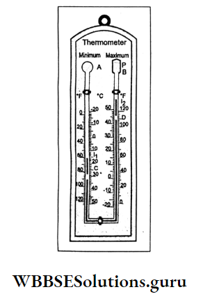
Measurement Of Heat
Air temperature is measured by a thermometer. It is of various types. The highest and lowest temperature of a day is measured by Six’s thermometer.
In 1782, James Six invented this thermometer which is named after the inventor. It records the maximum and minimum temperature of the day.
Two types of scales, celsius and Fahrenheit for measuring air temperature are used in this thermometer.
Maximum And Minimum Temperature
The highest temperature of the day (24 hours) is recorded as the maximum temperature and the lowest temperature of that day (24 hours) is recorded as the minimum temperature in Six’s thermometer.
Average Daily Temperature:
Maximum and minimum temperatures of a day at any place are added and divided by two to obtain the average daily temperature.
Daily Range Of Temperature:
The difference between the maximum and minimum temperature of a day at any place is the daily range of temperature.
Calculation
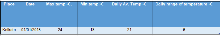
Average daily temperature is =24°C + 18°c = 42°C ÷2 = 21°c
Daily range of temperature is 24°C – 18°C = 6°C
Monthly Average Temperature :
The average daily temperatures of a month are added and then divided by the number of days of that month to get the monthly average temperature of a place.
Monthly Range Of Temperature :
The difference in temperature between the average highest temperature and the average lowest temperature of a month is the monthly range of temperature of a place.
Class 10 Geography And Environment Chapter 2 Solutions
Calculation
The temperature of January (°C)
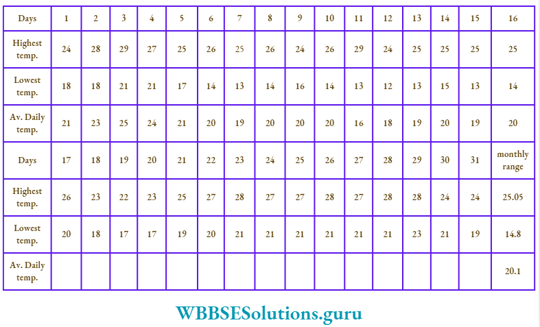
The monthly average temperature of January is 20.1°C
Monthly range of temperature’s (25.5°C – 14.8°C) = 10.7°C
Annual Average Temperature :
The average monthly temperature of twelve months is added and then divided by 12 to obtain the annual average temperature.
Annual Range Of Temperature :
The difference in temperature between the highest monthly average temperature and a lowest monthly average temperature of a place.
Calculation
Temperature (°C)

The annual average temperature is 26.7°C and the Annual range of temperature is (31.5°C – 22.0°C) = 9.5°C.
Causes Of Variation In Atmospheric Temperature:
The atmosphere is heated mainly by terrestrial radiation, but the air temperature is not uniform on the Earth. The following factors are responsible for variations in air temperature.
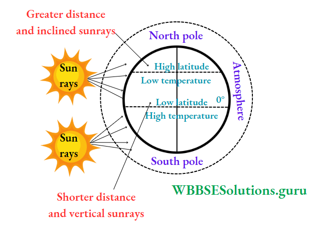
Latitude
Temperature decreases from the equator to the poles because the equatorial region receives vertical rays, while inclined rays spread over the polar regions.
Vertical rays are responsible for more air temperature because,
- It passes through a relatively short distance in the atmosphere, so absorption of heat by dust, water vapour, and carbon dioxide present in the air is less, so more heat is received, Oblique rays spread over a greater extent. So temperature decreases away from the equator towards north and south. Temperature decreases away from the equator.
- The temperature of Tirubanantapuram (8°30′ north) is higher than that of Srinagar which is located at 34° north latitude.
Class 10 Geography Chapter 2 Question Answers
Altitude Of A Place
Usually, the temperature of the air decreases at the rate of 0-6°C per 100-metre rise. This is known as Lapse Rate or Normal Temperature Lapse Rate.
So higher places experience low temperatures. The temperature of Darjeeling is less than that at Siliguri (located on the plain) though these two places belong nearly to the same latitude.

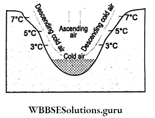
Inversion Of Temperature
Sometimes respecting the Lapse Rate, temperature increases with the increasing altitude of a place. This is known as the Inversion of temperature.
In mountain regions, cold and dense air slides down the mountain slopes into the valley by the earth’s gravitation! force. This is known as the Katabatic wind.
It lowers the valley temperature. In Europe, settlements and farmlands are, therefore, located on mountain slopes.
Distribution Of Land And Waterbodies
In summer water bodies are not as warm as landmasses. Similarly, in winter water bodies are not as cold as landmasses.
Therefore, summers and winters are mild in coastal regions due to moderating effect of the sea breeze and the coastal regions experience maritime climate.
But in the interior locations, summers are very hot and winters are very cold. So extreme or continental climate prevails there.
This is due to the differential heating and cooling of land and water.
Wind:
In winter cold wind from central Asia blowing over India reduces temperature, especially, in the northern plains.
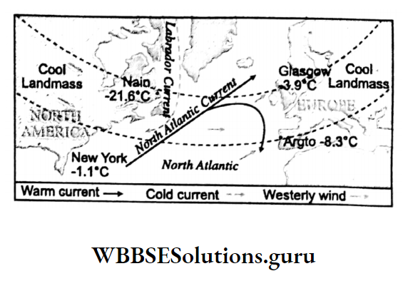
Ocean Currents :
A place will experience more air temperature, if, it is passed by warm ocean currents than the other place passed by cold ocean currents even though, the two places are located on the same latitude and altitude.
Nain and Glasgow though located on the same latitude, have different temperatures in winter because Nain receives Cold Labrador Current and Glasgow receives warm North Atlantic drift.
So, the temperature at Glasgow is 3.9°C it is -21.6°C at Nain.
Class 10 Geography Chapter 2 Question Answers
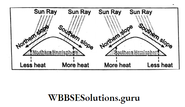
Slope Of The Land
In the northern hemisphere, the southern slope of the east-west oriented mountain range receives comparatively more vertical rays because of which it remains warmer than the northern slope of the mountain.
It happens so because the sun remains within the tropics during its apparent annual movement.
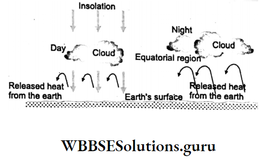
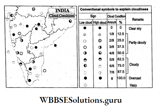
Cloud Cover And Precipitation
During the day cloud cover prevents the sun’s rays to reach the ground, so the air temperature of that place becomes low. But a cloudless sky allows the sun’s rays to reach the ground to the full extent and thus the air temperature of that place increases.
On the contrary, cloudless nights keep the air temperature low by releasing heat into space and cloudy nights store heat in the atmosphere, thereby, increasing the air temperature of that place.
In Rajasthan, the temperature of a cloudless day is nearly 45°C while at cloudless nights it drops to about 20°C.
Precipitation like rainfall and snowfall is also responsible for lowering an air temperature of a place. Pre-monsoon rains in summer in India lower air temperatures.
Natural Vegetation
In dense forests, air temperature remains low as the sun’s rays cannot penetrate the forest. The release of water through transpiration from trees also causes rain which also lowers the air temperature.
The temperature of selva in Brazil is much lower than that of Kenya or Uganda where there is no forest.
Soil
Wet and dryness of the soil are responsible for variations in air temperature. The temperature of the humid soil of the Gangetic plain is less warm than that of the dry soil of the eastern part of Rajasthan.

Urbanisation And Industrilisation
Most parts of cities and towns are made of bricks, cement and concrete which are heated rapidly. So the temperature of cities and towns is high.
The heat emitted from the factories of industrial towns also increases air temperature. So the temperature in cities and town are higher than that of villages.
The temperature of Kolkata, Durgapur, and Jamshedpur is higher than in the adjoining countryside.
WBBSE Chapter 2 Atmosphere Heat Belts Isotherm And Horizontal Distribution Of Temperature
Heat Belts :
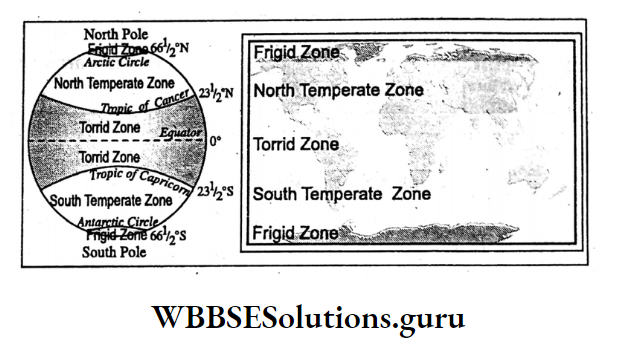
Based on variations in air temperature earth’s surface may be divided into Five heat or thermal belts or zones :
Torrid Zone :
Torrid zone is located between the Tropic of Cancer (23°30’N) and the Tropic of Capricorn (23°30’S). The region receives maximum heat because the equatorial region receives vertical rays twice in a year.
Variation in the length of day and night is minimum. Temperature is higher than any other places on the earth’s surface throughout the year.
Annual average temperature is 27°C. The isotherm 27°C is considered the northern limit of the Torrid zone. Places located between 30°N and S are included in this zone.
North Temperature Zone And South Temperate Zone :
North Temperate zone is located between the Tropic of Cancer (23°30’N) and the Arctic Circle (66°30’N) while South Temperate zone is located between the Tropic of Capricorn (23°30,S) and the Antarctic Circle (66°30’S).
Sunrays fall over these regions obliquely. Length of day and night is medium. Temperature remains moderate. Annual average temperature varies between 0°C and 27°C.
Due to higher temperature, regions close to Torrid zone (23°30/ to 45°) are known as warm Temperate zone. Due to low temperature, region close to Frigid zone (45° to 66°30′) are known as Cool Temperate zone.
Class 10 Geography Chapter 2 Wbbse Solutions
North Frigid Zone And South Frigid Zone
Regions beyond the Arctic circles and Antarctic circles are known as Frigid zones. North Frigid Zone lies between Arctic Circle (66°30’N) and North Pole (90°N) and South Frigid Zone lies between Antarctic Circle (66°30’S) and South Pole (90°S).
These regions receives very much inclined sunrays. They do not get sun rays for a few months in a year. Snowfall occurs most of the year and the land remains snow covered.
Annual average temperature is below 0°C. During long nights Auroras enlighten these regions.
Isotherm :
An imaginary line drawn on a map by joining the places having same temperature reduced to sea level is known as Isotherm, (‘iso’ means same and ‘thermos’ means temperature.
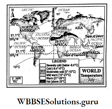
Horizontal Distribution Of Temperature
Distribution of global temperature may be understood with the help of isotherms.
As the months January and July experience extreme temperature conditions in a year so January and July isotherm give us some ideas regarding horizontal temperature distribution of the earth; such as :
- Highest and lowest temperatures of January and July are confined to land only.
- In January, isotherms on land masses bend towards the equator and over the equator bend towards the poles.
- Isotherms are Apart from each other in Southern Hemisphere because of more water bodies.
- Due to differential heating of land and water isotherms are not straight where land and water meet.
- Difference in temperature of two places is more in winter than that in summer. So in January, isotherms are closely spaced in Northern Hemisphere.
January Isotherm
- To the North of Asia, due to very low temperature (about — 40°C) isotherms do not follow the parallels, rather, they forms loops.
- Due to great differences in temperature in Northern Hemisphere isotherms are closely spaced.
- But in Southern Hemisphere (as it is summer) isotherms on the land bend towards the equator.

July Isotherm
- Temperature is high in Northern Hemisphere as it is summer there,
- Temperature is high in Central Asia and in North Africa, so isotherms becomes circular.
- In Southern Hemisphere water body is more and influence of warm current is also less. So, isotherms are more or less parallel to the parallels of latitude.
Global Warming—Role Of Green House Gases:
Class 10 Geography Chapter 2 Wbbse Solutions
Global Warming
The earth is heated by the small wave solar radiation. Sunrays reflected from the earth’s surface to space is in the form of long wave.
But these long wave terrestrial radiation is absorbed by the greenhouse gases which are increasing day by day in the troposphere.
As a result, temperature of atmosphere increases. This abnormal rise of atmospheric temperature is known as Global Warming.
Role Of Green House Gases
Green houses gases responsible for global warming are carbon dioxide, ozone, methane, chloroflurocorbon etc.
The amount of greenhouse gases in the atmosphere is increasing due to excessive burning of fossil fuel, deforestation, application of nitrogen fertilizer etc.
carbon dioxide alone is responsible for a 49% increase of air temperature. Warming capacity of one molecule of chloroflurocarbon is equal to that of 10,000 molecules of carbon dioxide.
Comparative warming capacity of different greenhouses gases in respect to carbon dioxide is listed below:
| Green House Gases | Warming capacity in respect to CO2 | Role in increase in global air temperature |
| 1. Carbon dioxide, CO2 | 1 (equal) | 49 |
| 2. Water Vapour,H2O | 5 times less | 13 |
| 3. Ozone, O3 | 10 times more | |
| 4. Methane, CH4 | 23 times more | 18 |
| 5. Nitrous OxideN2O | 270 times more | 6 |
| 6. Chlorofluro Carbon, CFC | 10,000 times more | 14 |
Effects Of Global Warming
Melting Of Polar Ice Caps And Mountain Glacier :
Due to global warming most of the ice and glaciers of polar region and mountainous land will melt. As a result, snowfed rivers will be dried up leading to severe water crisis.
Rise Of Sea Level :
Due to global warming ice melt water will add to the seas and oceans. As a result, sea level will rise and coastal regions will be flooded and salinity of the soil will be increased.
Change In Nature In Precipitation :
Due to global warming evaporation rate will be high which will increase amount of water vapour in the atmosphere.
Consequently, many dry parts of the earth will receive rainfall, snowfall, hailtorms etc. Again, due to high temperature many humid regions will turn into dry regions.
Class 10 Geography And Environment Notes WBBSE
Over And Under Production Of Crops :
Due to global warming there will be changes in the distribution of rainfall which will cause overproduction in dry regions and many humid regions will face underproduction due to a lack of rainfall.
Change In Agricultural Methods :
Due to changes in pattern of rainfall distribution caused by global warming there is changes in agricultural methods also. In dry region due to heavy rainfall wet farming and m humid regions due to scarcity of rain dry farming will be practised.
El-Nino And Its Global Effect :
Due to global warming El-Nino will be more frequent in Peru coast. In the years of El Nino there will be worldwide over rains, scarcity of rains and droughts.
Imbalance Earth’s Incoming And Outgoing Solar Radiation :
Since time immemorial the earth’s heat budget or heat balance between short wave insolation and long wave terrestrial radiation is maintained which is congenial for the living world.
But global warming will reduce terrestrial radiation which in turn, will increase heat waves, cold waves etc. and ultimately, will create crises in the living world.
WBBSE Chapter 2 Atmosphere Pressure Belts And Wind
Concept Of Air Pressure:
Concept:
Air pressure is the gravitational pull of the earth exerted on air i.e. the weight of the air given on the earth’s surface.
Actually, air exerts pressure on all matters in all directions. But, we do not feel air pressure as the pressure within our body is equal to the air pressure outside the body. Air pressure is of two types
- High pressure in which more air molecules are present and
- Low pressure in which fewer air molecules exist. Air pressure is expressed in millibar (MB). An air pressure of 1013 MB or more denotes high pressure, while an air pressure of 986 Mb or less indicates low pressure of air.

Measurement Of Air Pressure :
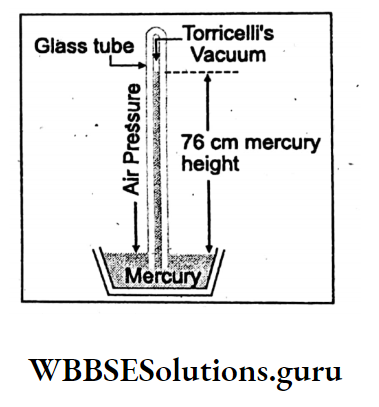
Air pressure is measured by Barometer. In 1643 scientist Torricelli discovered Barometer. Later on, Fortin’s Barometer and Aneroid Barometer were produced. Fortin’s Barometer is widely used.
Class 10 Geography And Environment Notes WBBSE
Torricelli Barometer
This simplest kind of barometer is the Torricellian barometer. This is an inverted (upside down) glass tube standing in a bath of mercury.
Air pressure pushes down on the surface of the mercury, making some rise up the tube. The greater the air pressure, the higher the mercury rises.
Pressure is read off a scale marked on to the glass. Sea level air pressure in this barometer is 76 cm or equal to 1013 MB.
Fortin’s Barometer
This is a modified form of Torricelli’s barometer. It consists of a narrow glass tube of about 90 cm. which is closed at one end.
It is fitted with mercury and kept inverted in a cistern filled with dry mercury. The glass tube is protected in a brass tube. A scale graduated in mm is attached to the brass tube and functions as the main scale.
For accurate measurement, a vernier scale, which can slide over the main scale is fixed to the barometer. The bottom of the cistern is actually a leather bag.
There is an ivory pointer in the cistern placed at the top, and it coincides with the zero of the main scale. The level of the mercury column in the cistern is changed with the screw below it.
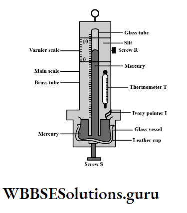
Working Procedure:
To Determine The Height Of The Mercury Column In The Barometer using an adjustment screw mercury level is to be set so that the ivory point just touches the mercury. Vernier scale is to be so adjusted that its edge and the corresponding reading in the main scale are set tangentially to the meniscus.
Vernier constant is to be fixed to note the readings on the main scale and the vernier scale.
Aneroid Barometer :
Lucien Vidie, The French physicist invented the aneroid (without liquid) the barometer in 1843. An aneroid barometer is a container that holds a scaled chamber from which some air has been removed, creating a partial vacuum.
An elastic disk covering the chamber is connected to a pointer by a chain and springs. With the change in atmospheric pressure, it contracts or expands causing the pointer to move accordingly over a dial.
Class 10 Geography And Environment Notes WBBSE
Advanced instruments:
The most modern instrument is MEMS or Micro electro-mechanical System. It is a micro (0,0001 – 0,01 mm) instrument which is used in electronic barometers.
There is also an automatic barograph which measures air pressure. Nowadays, an air pressure measuring automatic system is provided in smartphones, wrist watches etc.
Factors Affecting Atmospheric Pressure
Factors responsible for variation in air pressure on the earth’s surface are :
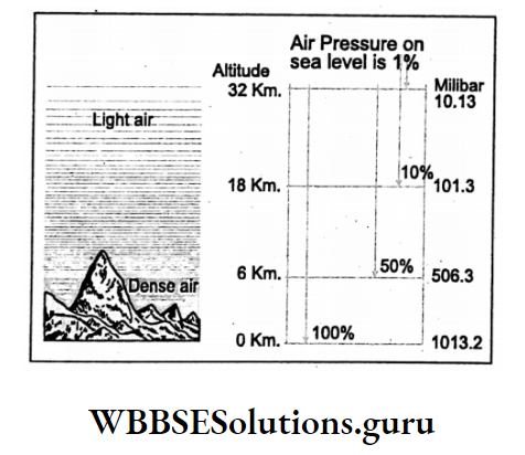
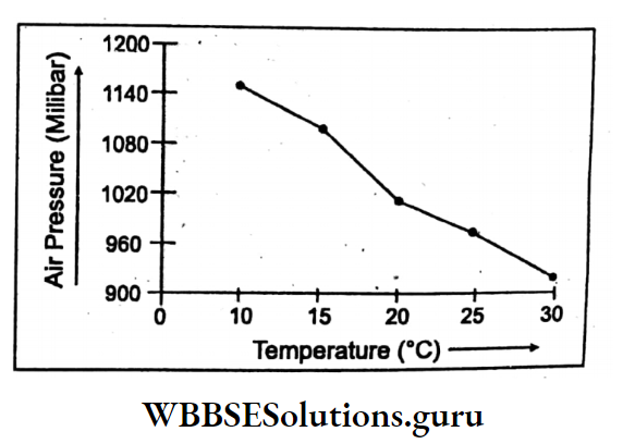
Altitude:
With an increasing height of place, air pressure decreases. On average for every 300-meter rise, there is a fall of air pressure by 34 MB.
Air Temperature:
Air pressure is inversely related to air temperature
- when air temperature increases, air expands and low pressure is developed, for Example. Equatorial Low-Pressure Belt,
- when temperature decreases air becomes dense and high pressure develops, Example. Polar High Pressure Belt.
Water Vapour:
In the rainy season, the air is moist. So it is light and low air pressure is formed. Dry air is dense and heavy. So it forms high pressure.
Rotation Of The Earth:
Due to the rotation of the earth, much of the air is removed from the polar region and the warm and light air above the equator is deflected to the north and to the south.
Finally, it descends over the tropics. Therefore, Sub-polar Low-Pressure Belts develop around 60* N and S. Sub-tropical High-Pressure Belts develop around 30° N and South latitudes.
Distribution Of Land And Water:
In mid-latitudes (30°- 60°) land is warmer than water in summer. In winter it is cooler than the water body. So low pressure develops on land in summer and high pressure develops on land in winter.
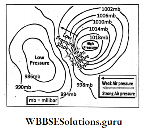
Isobar:
An imaginary line drawn on a map joining the places having the same air pressure reduced to sea level is called an isobar. Latin word ‘iso’ means same and ‘Baros’ means pressure.
Class 10 Geography And Environment Notes WBBSE
Pressure Gradient:
The change in atmospheric pressure per unit of horizontal distance in the direction in which pressure changes most rapidly is known as the Pressure gradient.
A weak pressure gradient is formed when isobars are far apart, while a strong pressure gradient is formed when isobars are closely spaced.
Pressure Belts Of The Earth—Shifting Of Pressure Belts, Winds:
WBBSE Chapter 2 Atmosphere Pressure Belts Of The Earth
On the earth’s surface, there exists a pattern of alternate high and low pressure throughout the year, each of them over a definite region almost encircling the earth. There are seven pressure belts on the Earth’s surface.

1. Equatorial Low-Pressure Belt:
Location on either side of the equator extending between 5°-10° N and S latitudes lies the Equatorial Low-Pressure Belt throughout the year.
Origin:
It is formed due to
- Falling of vertical sun rays over the equator throughout the year.
- There is a vast water surface from which the air gets plenty of moisture and
- The rotation of the earth detects the air of the layers above the equator towards the north and the south. So there is a continuous ascent of light air because of which this low-pressure belt is formed.
2. sud- a tropical high-pressure belt of the northern hemisphere and
3. High-Pressure Belt of Southern Hemisphere.
Location:
There are two high-pressure belts located between 35° N and S latitudes.
Class 10 Geography And Environment Notes WBBSE
Origin:
The reasons for the formation of these two high-pressure belts are
- Warm and light air above the equator rises, cools at higher altitudes and is deflected by the rotation of the earth polewards in both the hemispheres finally this cool and heavy air descends over the tropics,
- Due to the rotation of the earth cold wind of the polar region moves towards these regions. Therefore, there is a continuous descent of cold air over these regions and this is known as Sub-Tropical Calm.
4. polar High-pressure belt of the Northern Hemisphere and
5. Polar High-Pressure Belt of Southern Hemisphere.
Location:
High-pressure belts develop around the North Pole and around the South Pole.
Origin:
These high-pressure belts develop mainly due to
- The air is very cold, therefore, it is dense and heavy,
- Evaporation is slow, therefore, moisture is less,
- Air rising from the sub-polar low-pressure belt also comes down over this region.
6. Sub-polar Low-Pressure Belt of-Northern Hemisphere and
7. Sub-polar Low-Pressure Belt of Southern Hemisphere
Location:
Low pressure develops around the Arctic Circle and Antarctic Circle.
Origin:
- The rotation of the earth causes the air of these regions to move towards the equator,
- Air moving from the two poles towards sub-polar regions expands because of the greater extent.
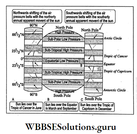
Shifting Of Pressure Belts
Ideal positions of the pressure belts are not found all the time everywhere. They may shift due to the northerly and southerly annual apparent movement of the sun.
They shift by 5°-10° to the north and to the south with northerly (May-July) and southerly (Nov-Jan) annual apparent movement of the sun.
They’re a great influence on the shifting of pressure belts in world climates,
- With the northerly apparent movement of the sun, the Equatorial Low-Pressure Belt shifts to the north by 5°-8° northwards. As a result, the southeast trade wind crosses the equator and according to Ferret’s law becomes the southwest monsoon wind.
- Places between 30° and 40e latitudes in both hemispheres come under the influence of westerlies in winter and dry trade winds in summer.
WBBSE Class 10 Environment Chapter 2 Important Points
Winds
The horizontal movement of air from one place to another on the earth’s surface is known as wind. The mechanism of blowing wind is mainly caused by the variation in air pressure on different parts of the earth.
Wind always blows from the region of high pressure to the region of low pressure. Winds are of four types
- Planetary winds,
- Periodic winds,
- Local winds,
- Sudden or Irregular winds.
Planetary Winds
Winds blowing permanently on the earth’s surface throughout the year in a definite direction from the high-pressure belts to low-pressure belts are Known as Planetary or Prevailing wind. They are three types
- Trade winds,
- Westerlies and
- Polar wind.
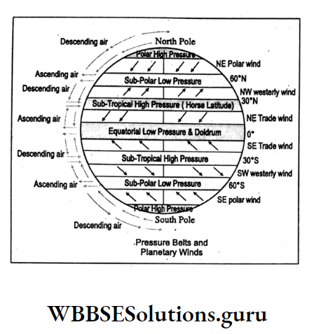
Trade Winds:
The word ‘Trade’ means track. Winds move in a definite track to the Equatorial Low-Pressure Belt. Trade winds move from Sub-Tropical High-Pressure Belts to the Equatorial tow Pressure Belt.
According to Ferrel’s law, they deflect to their right in the northern hemisphere and to their left in the southern hemisphere.
Westerlies:
Winds blowing from the Sub-Tropical High Pressure Belts to Sub-Polar Low-Pressure Belts are Known as Westerlies. They blow from 35°s N and S to 60° N and S latitudes.
Polar Winds:
Winds blowing from the Polar High Pressure Belt to Sub-Polar Low-Pressure Belts in both hemispheres are known as Polar winds. They blow from 65° to 80° latitudes in both hemispheres.
Periodic Winds
Variations in air temperature and pressure causes winds to change their direction for a specific period. This type of wind is called Periodic wind, for Example.
- Land Breeze,
- Sea Breeze,
- Monson Winds and
- Mountain and Valley Breeze
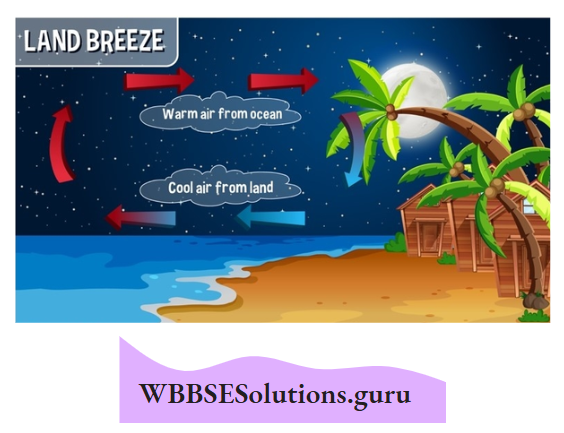
Land Breeze:
At night landmass cools faster than the adjacent water body due to the differential cooling capacity of land and sea.
Thus, low temperature forms high pressure on land from which wind blows to the low pressure of waterbody where the temperature is relatively high. This is known as a land Breeze. It becomes strongest in the morning.
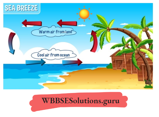
Sea Breeze:
During the day, the landmass warms up faster than the adjacent waterbody because of the differential heating and cooling capacity of land and sea.
Thus, the high temperature on landforms is low pressure to which wind blows from the high pressure of the sea where the temperature is comparatively low.
WBBSE Class 10 Environment Chapter 2 Important Points
This is known as Sea Breeze. It is strongest in the afternoon and blows with a speed of 15 km. per hour in a temperate region.
Monsoon Wind:
The word ‘Monsoon’ is coined from the Arabian word ‘Mausim’ meaning ‘season’. This is large-scale land and sea breeze that blows as southwest monsoon wind in summer from the high pressure of the Indian Ocean to the low pressure of the Indian landmass.
It blows as north-east monsoon wind in winter from the high pressure of the Indian landmass to the low pressure of the Indian Ocean.
Mountain And Valley Breeze:
In lofty mountainous land at night, mountain wind and during the day, valley wind blow. At night cold and heavy air is drained into the valley by the gravitational pull of the earth.
This is known as the Mountain wind or Katabatic wind (the Greek word ‘Kata’ means ‘down’). During the day in calm sunny weather, a hill or mountain top will be radiatively warmed by the sun and in turn, heat the air just above.
Air at a similar altitude over an adjacent valley or plain does not get warmed so much and high pressure is formed from which wind blows up the hill.
This upslope wind is known as the Anabatic wind. The Greek word ‘Ana’ means ‘up’.
Local Winds
Local winds are caused locally due to relief, environment etc. There are two types:
- Warm local winds are Fohn, chinook, loo, sirocco and
- Cold local winds are mistral, bora.
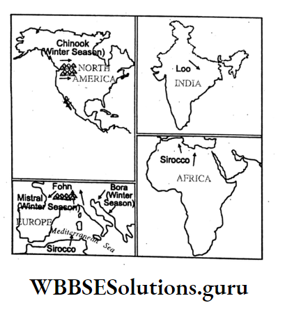
Fohn:
It is a hot and dry wind which blows along the southern slopes of the Alps into the Rhine Valley and helps in blooming flowers.
Chinook:
The word ‘Chinook’ means ‘snow eater’. It is a hot and dry wind which blows along the eastern slopes of the Rockies into the plains of Prairie and melts ice in winter, thus, helping in agriculture.
Sirocco:
It is a warm dry dusty wind which originates in the Arabian and Sahara desert and flows towards the Mediterranean Sea. It is called Sirocco in Sicily of Italy.
Loo:
During summer hot and dry wind blows over the plateau of Uttar Pradesh, Bihar, and Jharkhand in India. This is known as Loo.
WBBSE Class 10 Environment Chapter 2 Important Points
Mistral:
The cold and dry wind which blows from the Alps in Europe into the Rhone Valley in Southern France in winter is known as Mistral.
Bora:
It is a cold and dry wind which blows on the Adriatic coast of Italy.
Sudden Or Irregular Winds
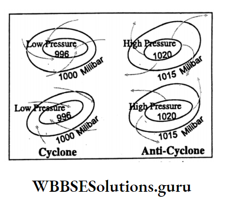
Cyclone:
Irregular winds with strong storms are called cyclones. In the cyclone, winds from outside blow spirally inside towards the centre. It moves clockwise in Southern Hemisphere and anti-clockwise in Northern Hemisphere. Cyclones are of two types-Tropical cyclones and Temperate cyclones.
Tropical Cyclone:
Deep depression or low pressure may develop due to high temperatures over the oceans between 5° N to 30° S latitudes of the tropical region.
Due to low pressure (fall of air pressure by 20 to 40 MB within a few hours) cold and heavy air rushes into the centre of low pressure and finally rises with a great speed. This is known as a Tropical cyclone.
Centre of the cyclone Strong wind where the lowest air pressure prevails is known as the eye. It is characterised by calm and stable weather conditions. It is encircled by dense cumulonimbus cloud which causes heavy rain with storms.
This is known as ‘Cyclone’ in the Bay of Bengal and the Arabian Sea, ‘Typhoon’ in the China Sea, ‘Hurricane’ in the Caribbean Sea ‘Wily Wily’ in Australia and ‘Baguio’ on the Philippine coast.

Anti-Cyclone:
In anti-cyclone wind blows spirally outward from the centre of the high-pressure cell in a clockwise circulation in Northern Hemisphere and in an anti-clockwise circulation in Southern Hemisphere. Anti-cyclone presents stable weather conditions.
Tornado:
In the southern part of the U.S.A., a devastating short-lived cyclone of land origin is known as Tornado. A dense cloud descends like a funnel which picks up almost everything on its way.
WBBSE Class 10 Environment Chapter 2 Important Points
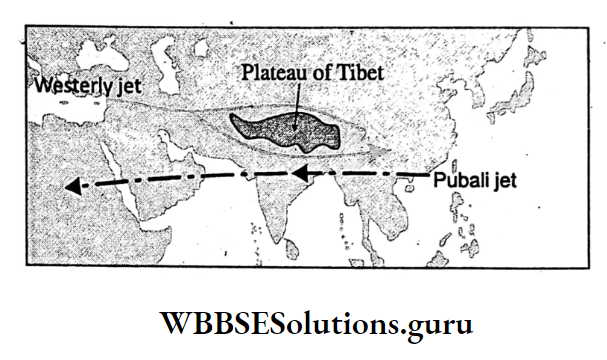
Jet Stream
A jet stream is a strong flowing ribbon of air that flows in the upper part of the Troposphere (10 12 km height). It blows with a speed of a minimum of 90 km to a maximum of 500 km per hour.
It stretches for a few km. Jet streams are of three types-Polar, Sub-tropical and Westerly jet Tropical jet streams.
Relation Between Monsoon And Jet Streams:
with the southerly movement of Sub-tropical westerly jet streams in winter, the North-east Trade wind becomes stronger and more active.
In India and intensity of coldness in winter increases with the northerly shifting of the tropical easterly jet stream (Pubali jet) in the rainy season, south-west monsoon wind becomes weak and causes scanty rainfall and drought in India.
WBBSE Chapter 2 Atmosphere Humidity And Precipitation
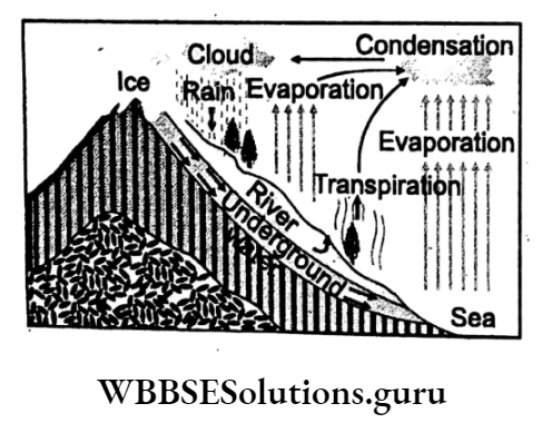
Concept Of Hydrological Cycle:
About 3/4th of the earth’s surface is water which rotates in cycles in its three forms- liquid (water), gas (water vapour) and solid (ice).
The hydrological cycle or water cycle begins with the evaporation of water from the earth’s surface. As moist air rises, it cools and water vapour condenses to form clouds.
They have been transported to the earth’s surface again through precipitation it is either in the form of rain or snow. Some of it again evaporates and back into the atmosphere while part of it may penetrate the surface.
Groundwater either seeps into the ocean river or streams through springs are released back into the atmosphere through the transpiration of plants.
WBBSE Class 10 Environment Chapter 2 Important Points
The rest is the surface runoff which empties into lakes, rivers and streams and is finally back to the ocean from where the cycle begins again.
The water cycle plays a great role in the sustenance of life, the texture of the soil, the physiological processes of plants, the control of climate and the sustenance of the ecosystem.
Evaporation:
Evaporation is the process of transformation of water from the earth’s surface into a gaseous phase on water vapour.
Evaporation plays an important role in the formation of clouds, rain, fog and dew as it supplies water vapour into the atmosphere. Therefore, it also controls the weather and climate of a place.
Humidity:
Air containing water vapour is referred to as humid air. Humidity is the dampness of the atmosphere. Humid air consists of 2 to 5 per cent water vapour. Air without water vapour is known as dry air. Humidity is expressed in three ways
- Absolute humidity,
- Specific humidity and
- Relative humidity.
Absolute humidity:
This is the mass of water vapour in grams contained in one cubic centimetre of airmass.
Specific humidity:
The amount of water vapour in gram present in one kg. of air is known as Specific humidity eg. 20 gm. per kg.
Relative humidity:
This is the ratio between the absolute humidity and the amount of water vapour the air can hold at a given temperature, expressed in percentage, therefore, Relative humidity is
⇒ \(\text { Relative humidity }=\frac{\text { Absolute humidity }}{\text { Saturation content at the same temperature }} \times 100\)
Example:
47% relative humidity indicates that the air is unsaturated and holds 47% of the water vapour which is required to make it saturated.
Saturated Air:
Air containing its maximum capacity of water vapour is known as saturated air. Air containing less than its maximum capacity is known as unsaturated air.
Air can be said saturated if the relative humidity is 100%; otherwise, with less than 100% relative humidity in the air is said to be unsaturated air.
If the temperature of saturated air is decreased or water vapour is added to saturated air excess water will condense and form clouds to give rain.
Dew Point:
Usually, the air is unsaturated. But it may become saturated with the same water vapour content if temperature decreases because, at a lower temperature, the water retaining capacity of the air also decreases.
The temperature at which air becomes saturated is known as the dew point. At the dew point relative humidity is 100%. The air releases its extra water vapour content so that it condenses to form dew.
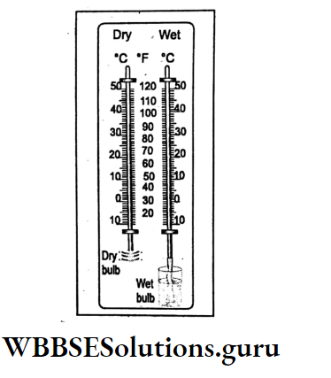
Measurement Of Humidity:
The relative humidity of air is measured by Hygrometer. It consists of dry and wet bulb thermometers.
Condensation And Its Different Forms
Moist air is light. So it rises and at high altitude it becomes cooled and ultimately at the dew point, the air becomes saturated.
Further cooling below the dew point turns water vapour into tiny water droplets or ice particles. This process is known as condensation.
Dew:
This is the condensation of water vapour into water droplets which rest on any surface like grass, leaf, roof etc.
WBBSE Class 10 Environment Chapter 2 Important Points
Fog:
These are condensation forms of water vapour into tiny water droplets which are floating in the air at a lower level of the atmosphere.
Smog:
In cities and towns smoke particles mix up with fog to form smog (smoke + fog = smog).
Cloud:
Moist and warm air is light. It rises and becomes cooled at higher altitudes. So condensation turns water vapour into tiny water droplets or ice particles which float in the air.
Thus floating particles are, together, known as clouds. These particles are very much tiny with an average diameter of 0.01 mm.
Precipitation-Concept:
Precipitation is the fall of water through the atmosphere on the earth’s surface in the form of rainfall, drizzle, snowfall, sleet or hail because of the droplets of water.
Ice or frozen water vapour in a cloud grows too large for updrafts. But fog, dew, and mist are not considered as precipitation as the throwing down of moisture is not involved in the mechanism of their formation
Class 10 Geography And Environment Chapter 2 Solutions
Rainfall
Bigger water drops in a cloud ranging between 0-2 and 6 mm in diameter fall as rain by the gravitational pull of the earth.

Types Of Rainfall:
Rainfall is of three types
- Convectional,
- Relief and
- Cyclonic.
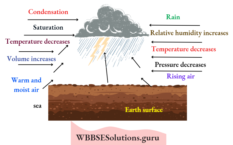
Convectional Rainfall:
In the equatorial region, vast stretches of water bodies get heated Relief rainfall-When warm and moist and the warm and moist air above rises.
It attains a high altitude in the conventional process and becomes cool. Thus the air becomes saturated at dew point temperature.
Further cooling leads to the condensation of water vapour into water drops which fall vertically on the earth. This is known as convectional rain. It occurs every afternoon.
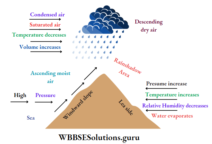
Relief Rainfall:
when warm and moist air is forced to rise the windward slope of a mountain or highland, it becomes cooled and condenses to give heavy rainfall on the windward side.
But on the lee side the air descends and gives no rain. Thus the region on the lee side becomes a rainshadow area.
Southwest monsoon wind gives heavy rain to the western slope of the Western Ghats but the eastern slopes, especially, the interior of the Deccan plateau remain a rainshadow area.
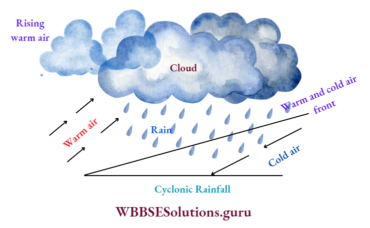
Cyclonic Rainfall:
Parallel to the earth’s surface, two converging air masses of different temperatures are responsible for the warm and light airmass rising over the cold and dense air.
In its ascent, the warm air cools. Condensations take place to cause cyclonic rainfall. This is common in Temperate regions.
In Tropical regions, low pressure develops on waterbodies and it causes cyclones associated with heavy rainfall.
Drizzle:
Sometimes, tiny water droplets (less than 0-5 mm in diameter) incessantly fall on the earth’s surface. This is known as a drizzle.
Snowfall:
In the upper part of the atmosphere where the temperature goes below freezing point, water droplets turn into ice particles to fall over the lofty mountains or in cold climatic regions such as snowfall.
Hail and Sleet:
In the upper part of the atmosphere, when water droplets ascend to a high altitude they turn into small grains of ice.
Class 10 Geography And Environment Chapter 2 Solutions
When these grains coalesce into bigger sizes, they fall to the earth like stones which are called hailstones and when they fall along with rain they are called sleet.
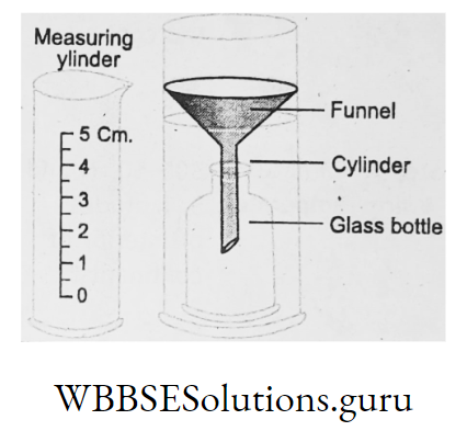
Measurement Of Rainfall:
A rain Gauge is used to measure the amount of rainfall. It is measured in mm, cm or inch.
Isohyte:
The imaginary line drawn on a map connecting the places with the same amount of rainfall is known as Isohyet.
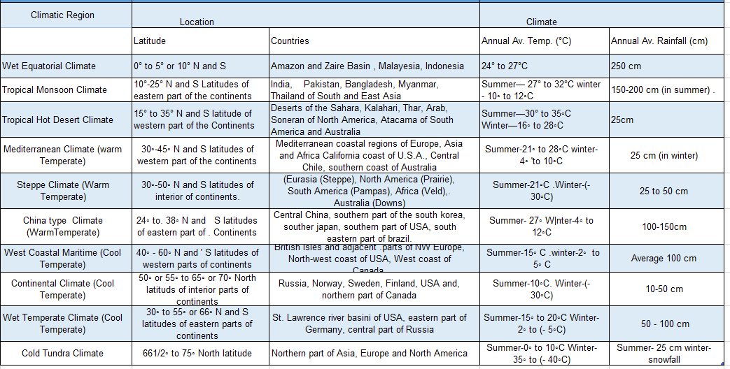
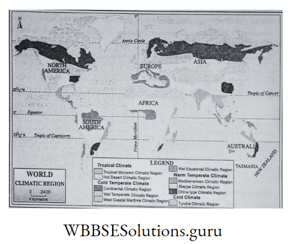
Major Climatic Regions Of The World:
There are certain areas of the world each of which has its own climatic characteristics, especially, identical temperature and rainfall conditions.
WBBSE Chapter 2 Atmosphere Principal Climatic Regions Of The World
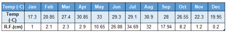
Identification Of Climate And Hemisphere With The Help Of Temperature And Rainfall Graph:
Representation of the average temperature and rainfall of a particular place at a particular time with a definite scale in a graph is known as a Temperature rainfall graph.
It helps to know many features regarding climate Example. the annual range of temperature of a place, the position of a place in which hemisphere from temperature.
The place belongs to which climate from the amount of temperature and rainfall, differences between climates of various places etc.
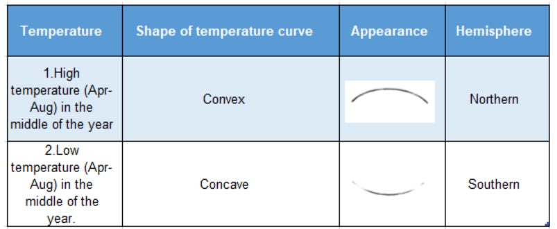
Identification Of Hemisphere:
The hemisphere to which a place belongs can easily be identified from the shape of the temperature curve of the temperature rainfall graph:
Identification
Wet Equatorial Climate :
Temperature:
- The high temperature throughout the year.
- The range of temperature is low.
Rainfall :
Rainfall takes place every month.
Annual rainfall is also high.
Hemisphere :
Temperature is high from September to March. So the place belongs to Southern Hemisphere.
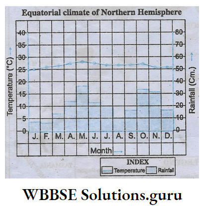
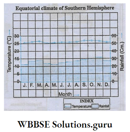
Climate :
Wet Equatorial Climate

Tropical Monsoon Climate
Temperature:
- High summer temperature.
- Mild winter temperature.
- The medium annual range of temperature.
Rainfall:
Summer rain, winter dry.
Hemisphere:
Temperature is high from March to August. So Northern Hemisphere.
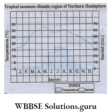
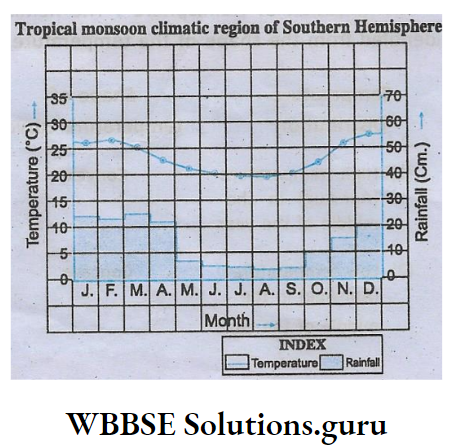
Climate:
Tropical Monsoon climate.
Tropical Hot Desert Climate
Temperature:
- Summer temperature is high.
- Temperature is low in winter.
- The annual range of temperature is high.
Rainfall:
Rainfall is insignificant.
Hemisphere:
Temperature is high from May to September. So, Northern Hemisphere.
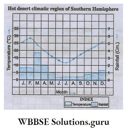
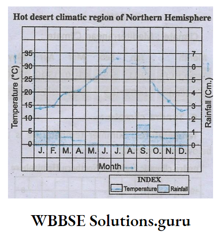
Climate:
Tropical Hot Desert Climate.
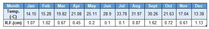
Mediterranean climate
Temperature:
Summer temperature is moderate.
Winter temperature is low.
Class 10 Geography And Environment Chapter 2 Solutions
Rainfall:
Winter rain and summer dry.
Hemisphere:
Temperature is high from October to March. So it is Northern Hemisphere.
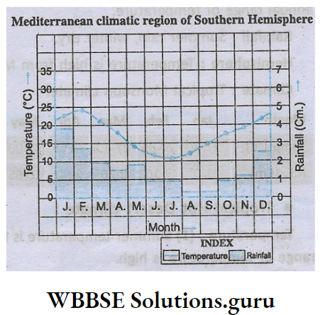
Climate:
Mediterranean Climate:
Tundra Climate
Temperature:
Summer temperature is too low. Most of the time-temperature remains below freezing point.
Rainfall:
Rainfall is insignificant.
Hemisphere:
Temperature is minimum from March to May. So it is Southern Hemisphere.

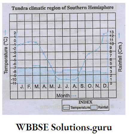
Climate:
Tundra Climate.
