
WBBSE Chapter 3 Hydrosphere Ocean Currents
70% of the earth’s surface is occupied by waterbody or hydrospheres. Seas, oceans, lakes, and rivers belong to this hydrosphere.
Oceans occupy about 60% of it. The most important feature of the ocean is its currents i.e. ocean currents.
Ocean Currents-Concept And Types :
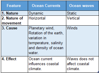
The horizontal movement of ocean water in a definite direction and regular pattern from one place to another is called ocean current. The vertical movement of ocean water is known as a wave.
WBBSE Notes For Class 10 Geography And Environment
Types Of Ocean Currents :
Ocean currents are of two types:
Warm Current:
Warm and light ocean water of the equatorial region moves towards the polar region as surface current. This is known as Surface current.
Cold Current:
Cold and heavy ocean water of the polar region moves towards the equatorial region. This is known as Under current.
WBBSE Chapter 3 Hydrosphere Causes Of Origin Of Ocean Currents
Factors responsible for the origin of ocean currents are:
Earth’s Rotation
Earth’s rotation causes the ocean water to be deflected to the right in the northern hemisphere and to the left in the southern hemisphere following Ferrel’s law because Coriolis force is produced by the rotation of the earth
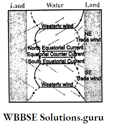
Wind
Ocean water is moved by the planetary winds in a clockwise direction in the northern hemisphere and in an anti-clockwise direction in the southern hemisphere.
- Trade winds move the ocean currents in the northeast direction in the northern hemisphere and in the southeast direction in the southern hemisphere.
- Westerlies move the ocean currents from the west to the east.
- Polar winds move the ocean currents from the east to the west.
Class 10 Geography And Environment Chapter 3 Solutions
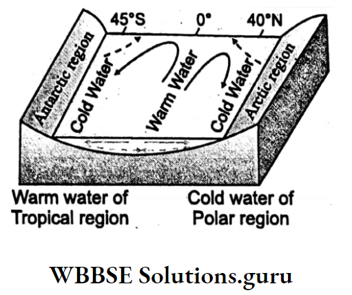
Temperature Of Ocean Water
Warm equatorial water is light. So, it flows along the surface of the ocean towards the poles as a surface current. But cold polar water is dense. So, it flows towards the equator as under current.
Salinity Of Ocean Water:
The salinity of ocean water varies. Less saline water is light. So, it flows as surface water while more saline water is dense. So, it flows as under current.
Density Of Ocean Water:
The density of ocean water depends on its temperature, salinity, and atmospheric pressure. Ocean water of high density flows under current towards the low dense ocean water.
Ocean water of low density flows as surface current towards the ocean water of high density.
Melting Of Ice:
In the polar region, the melting of ice causes the addition of ocean water leading to the ocean water being less saline. As a result, ocean water is moved to form ocean currents.
Shape Of Coastline:
Ocean currents are deviated and bifurcated due to the shape of the coastline of a continent as they are obstructed by the presence of landmasses.
Seasonal Variations:
With the change of seasons, the wind also changes its direction. As a result, with the change in wind direction ocean currents change their direction accordingly.
In summers in the Indian Ocean monsoon current flows to the right being moved by the southwest monsoon wind; while in winter it flows to the left being moved by the northeast monsoon wind.
The presence of oceanic ridges, evaporation, and variation in air pressure is also responsible for the origin of ocean currents.

WBBSE Chapter 3 Hydrosphere Effects Of Ocean Currents On The Earth
The following Are The Effects Of Ocean Currents:
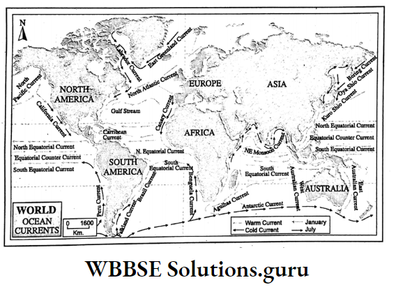
Formation Of Banks And Their Commercial Importance:
Commercial fishing grounds are formed where warm and cold ocean currents meet. Cold currents bring icebergs which melt when coming in contact with warm ocean currents and deposit moraines which are the main food for plankton.
As a result, large banks are formed, namely Grand Bank, Georges Bank near New Found land; Doggers bank, and Rockfall Bank near the British Isles.
Oceans are shallow and sunlight can reach the ocean bottom. So, Phyto planktons and zooplanktons which are the principal food for sea fish grow profoundly.
These banks are therefore the commercial fishing grounds of the world.
Coastal Climate
Countries passed by warm ocean currents experience warm weather conditions. Cold Labrador current keeps cool the coast of New Found land.
Warm Kuroshio current keeps warm the western coast of Japan. Wind originating over warm ocean currents picks up moisture and gives rain when blowing over the landmass.
But the wind blowing over cold ocean currents is dry and does not give any rain.
Where warm and cold currents flow side by side, water vapor of the warm current condenses in contact with the cold current, and foggy and stormy weather prevails due to the difference in temperature.
Climate Change
Ocean currents play an important role in the change of world climate. In general, the temperature of ocean water has already increased due to global warming.
consequently, the number and frequency of cyclones formed over warm ocean currents, namely Tropical cyclones, hurricanes, and typhoons, will have increased.
Due to the increase in evaporation over warm ocean currents rainfall over landmasses has also increased.
The origin and duration of the ‘El-Nino’ warm ocean current near Peru’s coast have increased. Similarly, ‘La-Nina’ near the western part of the Pacific Ocean has increased uncertainty over southeast Asian countries including India.
Class 10 Geography And Environment Chapter 3 Solutions
WBBSE Chapter 3 Hydrosphere Tides
Concept Of Tides, Origin:
Tides are alternate rise and fall of surface water. The rise of water is known as High tide while the fall of water is known as Ebb or Low tide.
Origin Of Tides
Tides are produced by
- Rotation of the earth and
- The gravitational pull of the sun and the moon.
Rotation Of The Earth:
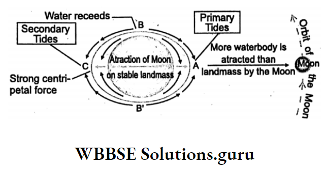
The centrifugal force produced by the rotation of the earth causes tides on the opposite side of the earth facing the moon.
Gravitational Pull Of The Sun And The Moon:
According to Newton’s law of gravity, the sun and the moon are responsible for generating high and low tides on the Earth’s surface.
But the moon is nearer to the earth, so it is mainly due to the gravitational pull of the moon, tides occur on the earth’s surface.
Lunar Tides And Solar Tides:
A Tide formed by the attraction of the moon is known as the Lunar tide and a tide formed by the attraction of the sun is known as the Solar tide. The lunar tide is stronger than the solar tide.
Primary Tides :
Places on the rotating earth facing the moon experience maximum pull by the moon and enjoy high tide. This is known as Primary tide.
Class 10 Geography Chapter 3 Question Answers
Secondary Tides :
Places on the earth opposite to places experiencing primary tides enjoy secondary tides due to the centrifugal force of the earth.
According to Newton’s law of gravity, the pull is directly proportional to the mass but inversely proportional to the square of its distance.
As the sun is 2 crores 60 lakh times heavier than moon but far away (150 million Km from the earth) from the moon (3 lakh 84 thousand Km from the earth) the gravitational pull of the moon is 2.2 times greater than that of the sun.
Low Tides:
When high tides are formed simultaneously low tides occur at the right-angled position of high tides as water moves away causing a lowering of surface water i.e. ebb or low tide.
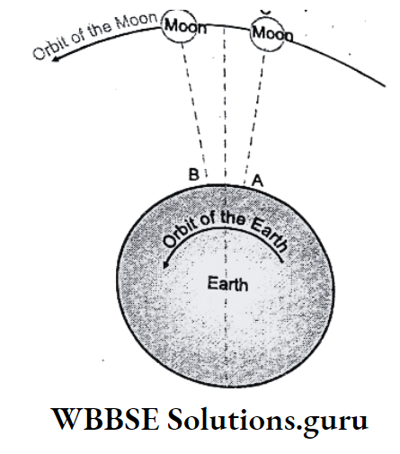
Tidal Interval
The time gap between two Primary High tides is 24 hours and 52 minutes. Moon takes nearly 27 days to revolve around the Earth and Earth spins once in 24 hours.
So, in one day the moon advances (360 27) 13° for which the earth requires 13 x 4 = 52 minutes more to experience another high tide.
The tidal interval between a primary and secondary high tide is 12 hours 26 minutes. Between one high tide and the next low tide, the interval is 6 hours 13 minutes.
So Secondary tide occurs 12 hours 26 minutes after primary tide low tide and takes place 6 hours 13 minutes after high tide.
Spring Tide
In the syzygy position (straight line position of the sun, moon, and the earth), either Full Moon or New Moon, the tidal range (difference in height between high and low tide) is highest. This is known as Spring tide.

Neap Tide
At the right-angled position of the sun and the moon when they counteract each other tidal range becomes the least. This is known as Neap tide.
Class 10 Geography Chapter 3 WBBSE Solutions
Syzygy
moon and the earth when lying on a straight line the position is known as Syzygy. If the sun and moon lie on the same side of the
earth, it is known as a conjunction, when. New Moon takes place.
If the earth lies in the middle. between the sun and the moon, the position is known as opposition, when Full Moon appears. In Syzygy positions i.e. on New Moon and Full Moon spring tides occur.

Apogee:
As the moon revolves around the Earth distance between the moon and the earth does not remain the same. When the moon is farthest from the earth the distance is 4,07,000 km. This is known as the Apogee position.
Perigee:
When the moon is nearest to the earth the distance is 3-56,000 km. This is known as the perigee position. In the perigee position High tides are highest and in the apogee position High tides are the least.
Class 10 Geography And Environment Notes WBBSE
WBBSE Chapter 3 Hydrosphere Ocean Currents Tidal Bore
A very large tidal wave about 5-7 meters high entering with great speed into an estuary is called a Tidal bore. It is common in the Hugli River estuary.
Conditions Of Tidal Bore:
A tidal bore is frequent
- During spring tide,
- To wide river and due to mouth,
- Obstruction from entering tide water into a river,
- Presence of funnel-shaped river mouth and
- Perennial river. In River Hugli, the height of the Tidal bore is 4-5 meters.
Effects Of Tides:
- Large vessels can enter the port with high tides and exit the port with low tides easily.
- Silts and urban wastes are washed away with the low tides.
- High tides turn the river water to be saline.
- High tides often cause river beds to be shallow by silting.
- During High tides, many sea fishes enter the rivers.
- In cool temperate regions, river ports remain frost free in winter because tide water turns the river water to be saline.
- Electricity is generated with the help of tidal energy.
- Tidal bores often damage settlements and farmlands.