Chapter 9 Maps And Scale Fundamentals Of Maps And Scale
Concept Of Maps And Scale
Maps are the graphical expression of different features of the earth’s surface like rivers, seas, oceans, mountains and hills, forests, roads and railways, bridges, religious places, etc.
Actually, a map is the blueprint of the earth’s surface on a plane surface with conventional signs and scale. Scale is the most important component of a Map.
Actually, a scale is depicted on a map to measure the actual (ground) distance between two places or features on the earth’s surface.
Read And Learn Also WBBSE Notes For Class 9 Geography and Environment
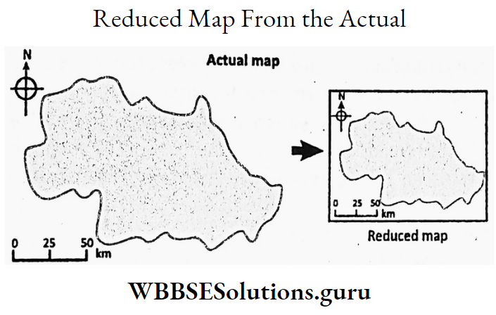
The actual distance between two places on the earth’s surface cannot be represented on a map (as it is smaller than reality), so, the ground distance is depicted on a map in a smaller ratio drawn to a scale.
A scale of a map is the relation or ratio between the distance on the map correspond to the distance on the ground.
For example. the scale of the map is 1 cm = 10 km, which means if the distance between two places on the map is 1 cm the actual distance between the places will be 10 km. So, without the scale, a map is meaningless.
WBBSE Class 9 Geography Chapter 9 Notes
Maps-Their Classification (Topographical Map Mouza Map Political Map Etc.)
On the basis of scale, purpose, information, and content maps are classified into different types. According to scale, maps are of three types–Small scale maps, Medium scale maps, and Large scale maps.
Small-scale maps are used to depict a large area of land, for Example. wall map, atlas, etc.
Medium-scale maps are used to depict a large area of land divided into smaller sections which are drawn to a medium-scale of ratio, Example. topographical map.
A large-scale map shows a small area of land drawn to a large-scale ratio, for Example. Souza map.
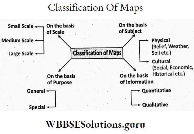
According to purpose, maps are of two types–General and Special. General maps are meant for common people to understand, easily, for Example. district map of West Bengal.
Special maps are drawn to use for a specific purpose. Example. climatic map.
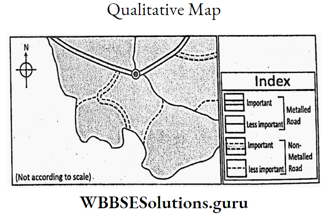
According to information, maps are of two types-Qualitative maps and Quantitative maps.
Qualitative maps show the different inequality of the subject. Example. in a road map metalled and unmetalled depict qualitative differences.
In a Quantitative map, quantitative dimensions like altitude, and density are shown. Example. density map of India.
On the basis of content, maps are of two types-Physical or natural and Cultural maps. In a Physical map elements like climate, natural vegetation, soil, etc. are shown.
In a Cultural map elements like social, economic, historical, and political items are shown. Maps are the most important tool to the Geographer for study and analysis. Important maps are Topographical, Mouza, Political, etc.
WBBSE Class 9 Geography Chapter 9 Notes
Chapter 9 Maps And Scale Topographical Maps
Topographical maps are prepared on the basis of a detailed survey of the physical and cultural elements of a region and shown with conventional signs and symbols drawn to a scale.
These maps are also known as Toposheets. These maps are medium-scale maps and vary between 1: 50,000 to 1: 100,000.
Mouza Maps Or Cadastral Map
Mouza (or village) maps are prepared by surveying and demarcating the boundaries, area of fields, buildings, etc., and drawn to a large scale which is usually 16 inches to a mile.
These are specially used in revenue offices to realize land revenue, taxes, etc. These are also used in the preparation of land use maps.

Political Maps
A political map depicts the international boundaries, state or administrative boundaries within a country, or even boundaries between regions.
In the political map of West Bengal, the boundaries of 23 districts are shown. It is a small-scale map with a ratio of 1 inch to 400 miles or 500 miles.
Chapter 9 Maps And Scale Uses And Importance Of Maps
Maps are used
- To know the location of a place or a country or region.
- Climatic characteristics of different regions of the world are known from the maps.
- Population maps are used to know the distribution and density of the population of different countries of the world.
- Economic maps are used to know the distribution and production of resources in different places of the world.
- Transport maps help to select the shortest transport system to reach the destination.
- Maps of a region published at different times explain how the geographical changes take place in that region.
- Astronomical maps show the location of stars and planets.
- Maps are very important tools for taking developmental plans of a region.
Class 9 Geography And Environment Chapter 9 Solutions
Chapter 9 Maps And Scale Scale-Their Types
The scale is the ratio of the relation between the distances of two places on the map and on the ground. Example. if the actual distance of 5 km is represented on the map by a distance of 1 cm the scale is 1 cm = 5 km.
The scale of a map is depicted in three different ways
- Statement,
- Representative Fraction and
- Graphical scale.
Statement Scale
When the ratio between the distance of two places on the map and the actual distance on the ground is expressed by a statement in a map it is said to be Statement Scale.
Example. 1 cm = 5 km. It is easy to express and understand. It does not involve any calculation. But if the size of the map is increased or decreased its scale cannot be used.
The scale of the map also cannot be converted from one unit of measurement (say mile) to another unit (km) of measurement.

Representative Fraction Scale
In this scale the ratio between the distance of two places on the map and the actual distance on the ground is expressed in Fractions in which the numerator is one and the denominator, is also in the same unit of measurement.
It is also known as R.F. Scale or Ratio Scale. Example. The scale is 1: 5000 means 1 unit distance on the map is equal to 5000 units distance on the ground.
Therefore, the advantages of this map are as follows. The advantages of this scale are
- It can be converted into any unit of measurement of length.
- It can also be changed into a statement or graphical scale.

∴R.F. 1=5000
But the R.F. Scale also has disadvantages
- This scale cannot be used if the map is increased or decreased in size.
- If the denominator is a big number then it is difficult to understand the ground distance.
Class 9 Geography And Environment Chapter 9 Solutions
Graphical Scale
Graphical Scale A straight line is graded into equal parts which represent the corresponding. ground distance in a map. It is a means of visually showing the scale of a map.
The graphical scale has advantages like
- It is easily apprehended.
- With the increasing
or decreasing the size of the map the scale also changes accordingly maintaining its accuracy. But the disadvantages of the graphical scale are
- It takes time for calculation and drawing.
- There are subtypes like Linear scale, Diagonal scale, Comparative scale, and Vernier scale which are difficult to understand.

Linear Scale
The linear scale is expressed by drawing a straight line. It has two parts
- Primary divisions and
- Secondary divisions.

Class 9 Geography And Environment Notes WBBSE
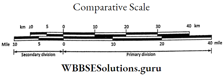
Comparative Scale
Scales of two different units of measurement are compared in a comparative scale. It is of two types
- Diagonal scale in which the ratio between the map distance and ground distance of two places is expressed in reference to a Diagon which connects the opposite corners of a square.
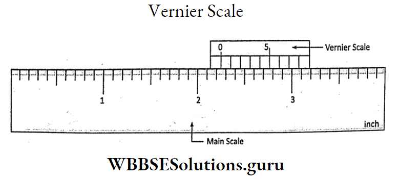
- Vernier scale in which a small movable graded scale is attached to the main scale to measure the fractions of the main scale.
Chapter 9 Maps And Scale Uses And Importance Of Scale
Scales are used for different purposes
- It is only possible with the help of a scale the three-dimensional earth can be represented on a two-dimensional plane paper.
- With the help of a scale, a map may be enlarged or reduced in size.
- With the help of a scale on a map, the ground distance between two places is easily calculated.
- The height and area of any place on the earth’s surface can be determined with the help of a scale.
- The scale of a map is very much important in the defense of a country.
- Scale is also important in surveys.